- Chattooga County, Georgia
-
Chattooga County, Georgia 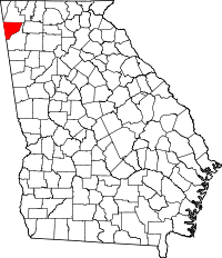
Location in the state of Georgia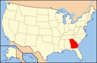
Georgia's location in the U.S.Founded 1838 Seat Summerville Largest city Summerville Area
- Total
- Land
- Water
313.55 sq mi (812 km²)
313.33 sq mi (812 km²)
0.23 sq mi (1 km²), 0.07%PopulationEst.
- (2006)
- Density
26,442
81/sq mi (31/km²)Time zone Eastern: UTC-5/-4 Chattooga County is a county located in the U.S. state of Georgia. It was created on December 28, 1838. As of 2000, the population was 25,470. The 2007 Census Estimate shows a population of 26,797.[1] The county seat is Summerville.[2]
Contents
Geography
According to the 2000 census, the county has a total area of 313.55 square miles (812.1 km2), of which 313.33 square miles (811.5 km2) (or 99.93%) is land and 0.23 square miles (0.60 km2) (or 0.07%) is water.[3] is water.
Major highways
 U.S. Route 27
 State Route 1
 State Route 48
 State Route 100
 State Route 114
 State Route 157
 State Route 337
Adjacent counties
- Walker County, Georgia - north
- Floyd County, Georgia - east and south
- Cherokee County, Alabama - west
- DeKalb County, Alabama - west
National protected area
- Chattahoochee National Forest (part)
Demographics
As of the census[4] of 2000, there were 25,470 people, 9,577 households, and 6,837 families residing in the county. The population density was 81 people per square mile (31/km²). There were 10,677 housing units at an average density of 34 per square mile (13/km²). The racial makeup of the county was 86.71% White, 11.21% Black or African American, 0.08% Native American, 0.12% Asian, 0.02% Pacific Islander, 0.84% from other races, and 1.02% from two or more races. 2.11% of the population were Hispanic or Latino of any race.
There were 9,577 households out of which 30.80% had children under the age of 18 living with them, 53.70% were married couples living together, 12.60% had a female householder with no husband present, and 28.60% were non-families. 25.20% of all households were made up of individuals and 12.40% had someone living alone who was 65 years of age or older. The average household size was 2.49 and the average family size was 2.94.
In the county the population was spread out with 22.90% under the age of 18, 10.00% from 18 to 24, 30.00% from 25 to 44, 22.80% from 45 to 64, and 14.30% who were 65 years of age or older. The median age was 36 years. For every 100 females there were 106.60 males. For every 100 females age 18 and over, there were 106.60 males.
The median income for a household in the county was $30,664, and the median income for a family was $36,230. Males had a median income of $26,505 versus $21,014 for females. The per capita income for the county was $14,508. About 11.30% of families and 14.30% of the population were below the poverty line, including 17.40% of those under age 18 and 14.90% of those age 65 or over.
Education
Main article: Summerville, Georgia#EducationHistory
Chattooga county has a long and interesting history. It is named for the Chattooga River, which flows through it. It was originally settled by the 'mound builder' culture. A few small mounds can be found throughout the Alpine and Menlo areas. Sometime in the pre-European settlement era, the county was settled by at first the Creek Native Americans and later the Cherokee Native Americans. The principle Cherokee towns in Chattooga were Rivertown (Trion) and Broomtown in Shinbone valley. With the onset of European settlers and after gold was discovered in northern Georgia, the federal government forcibly removed the Cherokees to Oklahoma from Chattooga county in the early 1830s in what has become known as "the Trail Of Tears." In this removal, thousands of Native Americans died from sickness, hunger and abuse. The land was then divided amongst white settlers in the Cherokee Land Lottery of 1832. The Lottery transformed Chattooga into a thriving agricultural area in the antebellum South with farms of varying size dotting the fertile landscape of the Chattooga Valley.[citation needed]
The coming of the American Civil War saw Chattoogans polarized into pro and anti-union camps. Confederate armies received five regiments from Chattooga. Several engagements were fought in the county prior to the battle of Chickamauga. General Nathan Bedford Forrest fought an engagement near Alpine with Federal cavalry resulting in the Federals being thrown back to the Chattanooga area. The largest single engagement in Chattooga was the "Battle of Trion Factory," fought on Sept. 15th, 1863 on present day First Street near the site of the East Trion Church of God. Confederate Infantry forces under the command of General Benjamin Hardin Helm and cavalry under the command of Gen. Joseph Wheeler defeated Union forces in a running battle that started somewhere near Summerville and ended in Trion. The front section of the Old Trion Cemetery on First Street contains the remains of fifty-five Union soldiers and seven Confederates killed in this action, but the graves are unmarked. In september 2009, the Chattooga County Camp 507, Sons of Confederate Veterans in conjunction with the Missionary Ridge Camp 63 Sons of Union Veterans, and several local groups erected a memorial monument to remember the "First Battle of Trion Factory" and the soldiers who are buried in unmarked graves at Trion. In an interesting side note, Confederate General Helm was a brother-in-law to Mary Todd Lincoln and was killed five days after the Battle of Trion Factory on Sept. 19th at the Battle of Chickamauga in Walker County, GA.[citation needed]
The Coming of Sherman
After the fall of Atlanta, Confederate General John Bell Hood led his Army of Tennessee from the Atlanta battlegrounds to the north and west in an attempt to lead General William Tecumseh Sherman's Army of the Cumberland away from Atlanta and out of Georgia. Sherman left a detachment in Atlanta while he took the remainder of his army in pursuit of Hood and his Confederates. General Hood's army passed through Chattooga County in September 1864 en route to Gaylesville, Alabama. General Sherman reportedly stated upon first seeing the Chattooga Valley from atop Taylors Ridge that it "is a good fertile valley suitable for agriculture."[citation needed] Upon reaching Summerville, Sherman was informed of a Confederate training camp some several miles up the river from town. General Sherman proceeded north about two miles and "fired a few shots at the retreating rear guard" of the Confederates.[citation needed] Reportedly, every road leading out of Chattooga to the west was filled with retreating Confederates. General Sherman telegraphed General Henry Halleck and president Abraham Lincoln from Summerville to outline his plan for the "March to the Sea," making Chattooga County the birthplace of his march.
Government and Politics
Chattooga County is a Democratic stronghold in Northwest Georgia. The NW GA region has followed the state, particularly the suburbs of Atlanta, in a dramatic political shift to the right. While most counties in Northwest Georgia vote heavily Republican on the local, state, and national levels, Chattooga is still a Democratic County. The county hasn't elected a Republican for local office since Reconstruction. The county has supported Republicans for national office, but by much closer margins than most areas of the region.
The county is in Georgia's 11th House District. Former educator and community leader Barbara Massey-Reece (D-Menlo) represents the district, which includes all of Chattooga and parts of Floyd County, in the State House of Representatives. The county is represented by Chickamauga Republican Jeff Mullis in the State Senate.
Chattooga County is served by a vast array of public offices. The county is one of the few in the State of Georgia that still operates under one county commissioner. Jason Winters, a local businessman, successfully defeated incumbent Democratic Commissioner Mike Dawson in the Democratic Primary election in 2008. Winters went on to defeat local businessman Charles Black, a Republican, in in the General Election to take the office. Winters' office is on Commerce Street in downtown Summerville, the county's seat.
Sheriff Ralph Kellett served the community as sheriff for almost two decades before losing the Democratic Primary election to John Everett in 2008. Sheriff Everett kept the seat in Democratic hands in the General Election. Everett's office is located on West Washington Street beside the county courthouse.
Other elected officers include Tax Commissioner Kathy Brown, Sam "Laan" Cordle as Clerk of Superior and State Courts, Earle Rainwater as Coroner, and Jon Payne as Probate Judge and Election Superintendent. Tim Perry serves as Solicitor General and Sam Finster is the State Court Judge. Judge Kristina Cook-Connelly, daughter of Attorney Bobby Lee Cook, is judge on the Lookout Mountain Judicial Circuit.
The county's school board, under Chattooga County School's Superintendent Dwight Pullen, oversees four elementary schools: Leroy Massey Elementary, Menlo School, Lyerly School, and Summerville Elementary, one middle school, Summerville Middle, and one high school, Chattooga County High School. Chattooga High School is a "Class AA" school according to the Georgia High School Association. The board also oversees one alternative school. The members of the school board are William Anderson, Eddie Elsberry, Dot Johnson, Eddie Massey, and Terry Money. The other school system in Chattooga County is the Trion City School System. The system, constantly named one of the best public schools in the State of Georgia, is served by Superintendent Dr. H. Phillip Williams. The school board is chaired by Chairperson Connie Witt. The system has one elementary,one middle, and one high school. The school is on one campus and is a "Class A" school according to the Georgia High School Association. The school was recently named a Georgia School of Excellence and had the top SAT scores for any school system in the State of Georgia. The school also has the highest graduation rate of any high school in the state.
Recreation
- Georgia State Parks & Historic Sites, Sloppy Floyd Lake Park
Chattooga County Notables
- Howard Finster, Christian folk artist
Cities and towns
- Cloudland
- Lyerly
- Menlo
- Pennville
- Summerville
- Trion
See also
- National Register of Historic Places listings in Chattooga County, Georgia
- Northwest Georgia Joint Development Authority
References
- ^ Census Bureau
- ^ "Find a County". National Association of Counties. http://www.naco.org/Counties/Pages/FindACounty.aspx. Retrieved 2011-06-07.
- ^ "Census 2000 U.S. Gazetteer Files: Counties". United States Census. http://www.census.gov/tiger/tms/gazetteer/county2k.txt. Retrieved 2011-02-13.
- ^ "American FactFinder". United States Census Bureau. http://factfinder.census.gov. Retrieved 2008-01-31.
External links

Walker County Cherokee County, Alabama and DeKalb County, Alabama 
Floyd County  Chattooga County, Georgia

Floyd County Municipalities and communities of Chattooga County, Georgia Cities 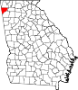
Towns Coordinates: 34°29′N 85°21′W / 34.48°N 85.35°W
- http://www.chattoogainfo.com/ News and information from Chattooga County
Categories:- Georgia (U.S. state) counties
- Chattooga County, Georgia
- 1838 establishments in the United States
- Populated places established in 1838


Wikimedia Foundation. 2010.