- Marietta, Georgia
-
Marietta, Georgia — City — Cobb County courthouse in Marietta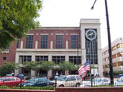 Location in Cobb County and the state of Georgia
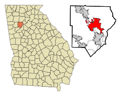 Location of Marietta in Metro Atlanta
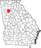
 Marietta
Coordinates: 33°57′12″N 84°32′26″W / 33.95333°N 84.54056°WCoordinates: 33°57′12″N 84°32′26″W / 33.95333°N 84.54056°W Country United States State Georgia County Cobb Government - Mayor R. Steve Tumlin, Jr. - City Manager William F. Bruton, Jr. Area - Total 22 sq mi (57 km2) - Land 21.9 sq mi (56.7 km2) - Water 0.1 sq mi (0.3 km2) Elevation 1,129 ft (344 m) Population (2010) - Total 56,579 - Density 2,570.9/sq mi (992.6/km2) Time zone EST (UTC-5) - Summer (DST) EDT (UTC-4) ZIP codes 30006-08, 30060-69, 30090 Area code(s) 770, 678 FIPS code 13-49756[1] GNIS feature ID 0317694[2] Website www.mariettaga.gov 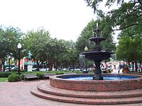 Historic Downtown Marietta
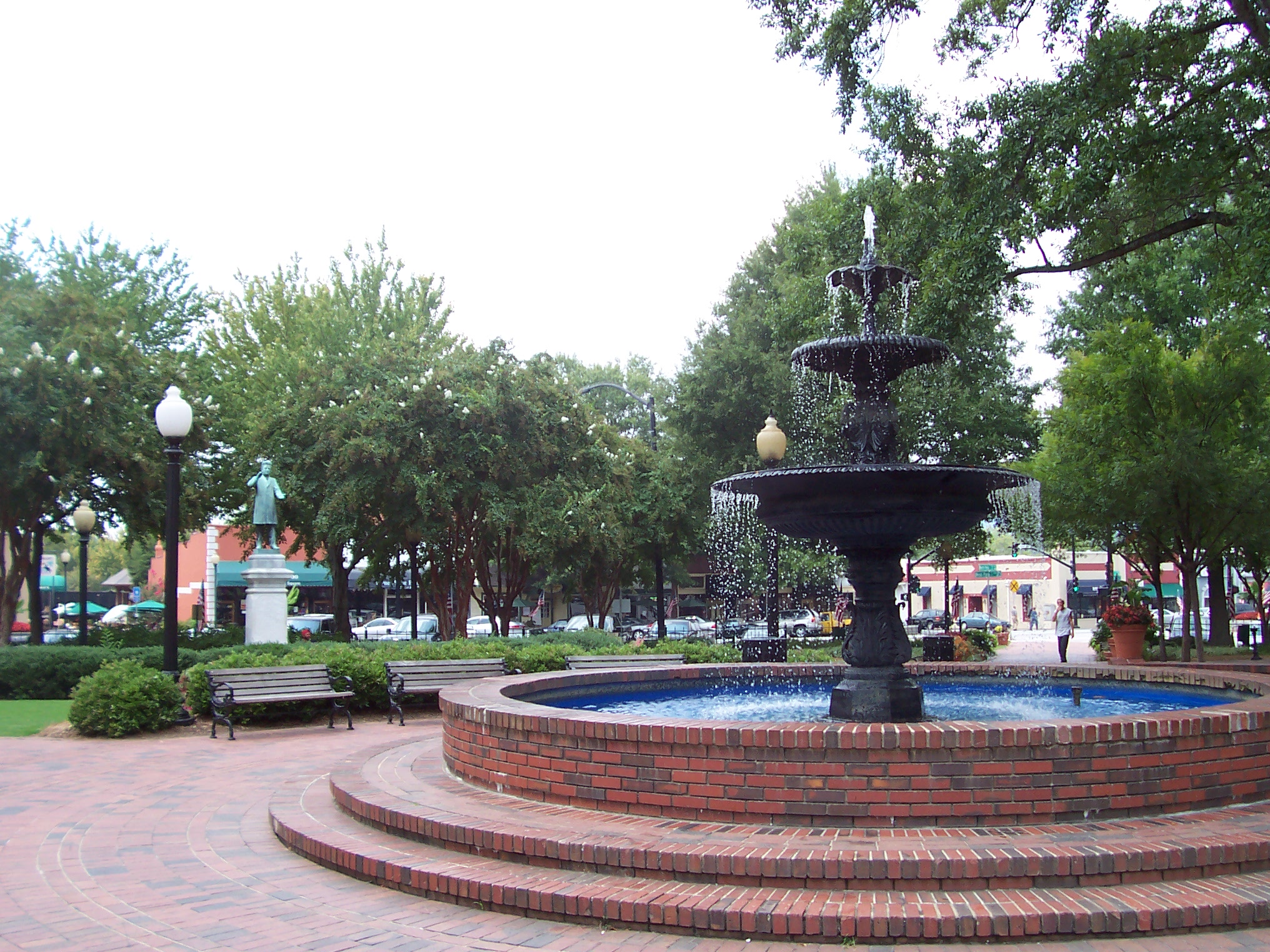
Marietta is a city located in central Cobb County, Georgia, United States,[3] and is its county seat.
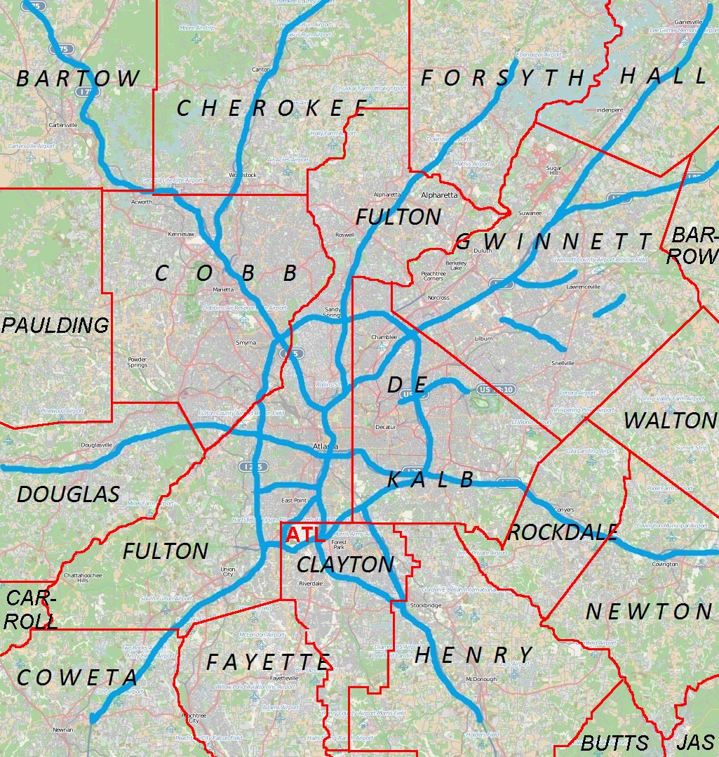
As of the 2010 census, the city had a total population of 56,579, making it one of metro Atlanta's largest suburbs. Marietta is the third-largest of three principal cities (by population) of and is included in the Atlanta–Sandy Springs–Marietta, Georgia, metropolitan statistical area, which is included in the Atlanta-Sandy Springs-Gainesville, Georgia-Alabama (part) combined statistical area.
Contents
History
Etymology
One story is the city was named for Mary Cobb, the wife of U.S. Senator and U.S. Supreme Court justice Thomas Willis Cobb.[4]
Early settlers
Homes had been built by early settlers near the Cherokee town of Big Shanty (now Kennesaw) by 1824.[5] The first plat was laid out in 1833. Like most towns, Marietta had a square in the center with a courthouse. The Georgia General Assembly legally recognized the town on December 19, 1834.[5]
Built in 1838, Oakton House[6] is the oldest continuously occupied residence in Marietta. The original barn, milk house, smoke house, and well house remain on the property. The spectacular gardens contain the boxwood parterre from the 1870s. Oakton served as Major General Loring's headquarters during the Battle of Kennesaw Mountain in 1864.[7]
Marietta was selected as the home base for the new Western and Atlantic Railroad, and business boomed.[5] By 1838, roadbed and trestles had been built north of the city. In 1840, political wrangling stopped construction for a time. In 1842, new management decided to use the area that would become Atlanta. In 1850, the railroad began operation, which was another boost to industry.[5]
Businessman and politician John Glover arrived in 1848. The town elected him mayor when it incorporated in 1852.[5]
Dr. Carey Cox promoted a "water cure", which developed into a spa that attracted patients to the area. The Cobb County Medical Society recognizes him as the county's first physician.[5]
The Georgia Military Institute was built in 1851.[5] The first bank opened in 1855.[5] During the 1850s, fire destroyed much of the city on three occasions.[5]
Civil War
By the time the American Civil War began in 1861, Marietta had recovered from the fires.[5]
In April 1862, James Andrews, a civilian working with Union soldiers, came down to Marietta dressed in civilian clothing and spent the night in the Fletcher House hotel (later known as the Kennesaw House and now the home of the Marietta Museum of History) located right in front of the railroad tracks. James Andrews and his men, known as the Andrews Raiders, had great plans to end the Civil War early. The Andrews Raiders got aboard the waiting train on the morning of April 12, 1862, with the rest of the passengers. When the train stopped in the town of Big Shanty, now known as Kennesaw, for the passengers to have breakfast, Andrews and the Raiders got back on the train and stole the engine and the car behind it, which carried the fuel. The train, called The General, and Andrews' Raiders had begun the episode now known as the Great Locomotive Chase.[5]
General William Tecumseh Sherman invaded the town during the Atlanta Campaign in the summer of 1864. In November 1864, General Hugh Kilpatrick set the town ablaze, the first strike in Sherman's March to the Sea.[5]
One of the few houses left standing, the Marietta Hotel, was later burned by the town residents who found out the owner of the building had been a Yankee spy during the Civil War.[citation needed]
The Marietta Confederate Cemetery is located in the city.
20th century
Leo Frank was lynched at Frey's Gin, just east of Marietta in 1915. (Frey was the county sheriff at the time.) Although it was for the alleged murder of Mary Phagan in Atlanta, it was primarily motivated by religious intolerance, as Frank was Jewish. This incident led to the founding of the Anti-Defamation League.
In the late 1960s, an amendment was passed to the Georgia State Constitution, giving home rule to the 159 counties in Georgia. Led by Ernest Barrett, the first county commission voted to demolish the historic county courthouse, which was located on the northeast corner of Roswell Street (former Georgia 120) and East Park Square (former Georgia 5) since 1888. This loss is now regarded as one of the county's biggest mistakes, and state law now requires a county-wide referendum before destroying historic county courthouses. Other historic buildings, such as the Works Progress Administration building, were also torn down at the time. The Glover Locomotive Works, which had been abandoned, was also torn down in the late 1990s despite its historic significance (although it was just outside city limits). As of 2010[update], another courthouse is under construction for the superior courts, adapting some minor design elements of the demolished courthouse.
The southwest corner of the square is also the origin for all street addresses in the county grid plan.
The city has six historic districts, some on the National Register of Historic Places. A seventh, along Kennesaw Avenue, is proving more controversial, and is still being considered as of March 2010[update]. The city's welcome center is located in the historic train depot.
At least two books have been produced chronicling the history of the city in pictures, both in the Then and Now series: Marietta (ISBN 978-0-7385-5314-6) and Marietta Revisited (ISBN 978-0-7385-6634-4).
Geography
According to the United States Census Bureau, the city has a total area of 22.0 square miles (57 km2), of which 21.9 square miles (57 km2) is land and 0.1 square miles (0.26 km2), or 0.27%, is water.
Climate
Marietta has a humid subtropical climate (Köppen climate classification Cfa).
Climate data for Marietta, GA Month Jan Feb Mar Apr May Jun Jul Aug Sep Oct Nov Dec Year Record high °F (°C) 80
(27)80
(27)89
(32)93
(34)96
(36)101
(38)104
(40)104
(40)99
(37)92
(33)86
(30)80
(27)104
(40)Average high °F (°C) 50
(10)55
(13)64
(18)72
(22)79
(26)86
(30)89
(32)88
(31)83
(28)73
(23)63
(17)54
(12)71 Average low °F (°C) 28
(−2)31
(−1)38
(3)45
(7)54
(12)62
(17)66
(19)65
(18)59
(15)46
(8)38
(3)31
(−1)47 Record low °F (°C) −12
(−24)−2
(−19)7
(−14)21
(−6)32
(0)40
(4)50
(10)48
(9)30
(−1)22
(−6)9
(−13)−4
(−20)−12
(−24)Precipitation inches (mm) 5.82
(147.8)5.08
(129)5.94
(150.9)4.50
(114.3)4.32
(109.7)4.25
(108)4.59
(116.6)4.40
(111.8)3.60
(91.4)3.58
(90.9)4.21
(106.9)4.34
(110.2)54.63
(1,387.6)Source: [8] Demographics
Historical populations Census Pop. %± 1960 25,565 — 1970 27,216 6.5% 1980 30,805 13.2% 1990 44,129 43.3% 2000 58,748 33.1% 2010 56,579 −3.7% As of the census of 2000, there were 58,748 people, 23,895 households, and 13,022 families residing in the city.[1] The population density was 2,684.1 people per square mile (1,036.2/km²). There were 25,227 housing units at an average density of 1,152.6 per square mile (445.0/km²). The racial makeup of the city was 56.49% European American, 33.50% African American, 0.32% Native American, 2.97% Asian, 0.09% Pacific Islander, 7.99% from other races, and 2.65% from two or more races. Hispanic or Latino of any race were 16.93% of the population.
There were 23,895 households out of which 27.8% had children under the living with them, 35.4% were married couples living together, 13.8% had a female householder with no husband present, and 45.5% were non-families. 32.8% of all households were made up of individuals and 6.9% had someone living alone who was 65 years of age or older. The average household size was 2.39 and the average family size was 3.05.
In the city, the population was spread out with 22.4% under the , 14.1% from 18 to 24, 39.4% from 25 to 44, 15.7% from 45 to 64, and 8.3% who were 65 years of age or older. The median age was 30 years. For every 100 females there were 101.3 males. For every 101 females age 18 and over, there were 100.3 males.
Government
Incorporated as a village in 1834 and as a city in 1852, the city of Marietta is organized under a form of government consisting of a Mayor, City Council and City Manager. The City Council is made up of representatives elected from each of seven districts within the city and a Mayor elected at-large.
The City Council is the governing body of the city with the authority to adopt and enforce municipal laws and regulations. The Mayor and City Council appoint members of the community to sit on the city's various boards and commissions, ensuring that a wide cross-section of the community is represented in the city government.
The City Council appoints the City Manager, the city's chief executive officer. The Council-Manager relationship is comparable to that of a Board of Directors and CEO in a private company or corporation. The City Manager appoints city department heads and is responsible to the City Council for all city operations. The City Council also appoints the city attorney who serves as the city's chief legal officer, and the City Clerk who maintains all the city's records.
Terms of office are for four years and the number of terms a member may serve are unlimited. There are seven councilman, each representing a separate ward.[9]
Former mayors
Mayors of Marietta, Georgia - John Hayward Glover 1852
- Joshua Welch 1853
- W. T. Winn 1854
- I. N. Heggie 1855
- N. B. Knight 1856
- J. W. Robertson 1857
- R. W. Joyner 1858
- I. N. Heggie 1859
- Samuel Lawrence 1860-1861
- J. A. Tolleson 1862
- W. T. Winn 1863
- H. M. Hammett, 1864. Hammett acted as Mayor until about July 1, 1864, at which time the city was invaded by the Federal Army and was occupied by them until November 15, when it was evacuated. In the meantime a large portion of the city had been reduced to ashes.
- C.C. Winn 1865. On re-establishing order, Winn was elected Mayor for 1865 and served until October 1, when he resigned. A. N. Simpson was elected to fill the vacancy.
- A. N. Simpson 1866-1868
- G. W. Cleland 1869
- William H. Tucker 1870-1873
- Humphrey Reid 1874
- William H. Tucker 1875
- Edward Denmead 1876-1877
- Humphrey Reid 1878
- Joel T. Haley 1879
- Edward Denmead 1880-1883
- Enoch Faw 1884
- W. M. Sessions 1885
- Edward Denmead 1886-1887
- Thomas W. Glover 1888-1893
- R. N. Holland 1894-1895
- D. W. Blair 1896-1897.[10]
- W. M. Sessions 1898-1899
- T. M. Brumby Sr. 1900-1901
- Joe P. Legg 1902-1903
- John E. Mozley 1904-1905
- E. P. Dob 1906-1909
- E. H. Clay 1910-1911
- J. J. Black 1912-1913
- E. P. Dobbs 1914–1915
- James R. Brumby Jr. 1916-1922 (Resigned 2/9/22)
- Gordon B. Gann 1922-1925 (Took office 3/9/22)
- E. R. Hunt 1926-1927
- Gordon B. Gann 1928-1929
- T. M. Brumby Jr. 1930-1938 (Deceased 8/20/38)
- L. M. Blair 1938-1947 (Took office 9/7/38)
- Sam J. Welsch 1948-1955
- C. W. Bramblett 1956-1959
- Sam J. Welsch 1960-1963
- L. H. Atherton Jr. 1964-1969
- James R. Hunter 1970-1973
- J. Dana Eastham 1974-1981
- Robert E. Flournoy Jr. 1982-1985
- Vicki Chastain 1986-1989
- Joe Mack Wilson 1990-1993 (Deceased 5/17/93)
- Ansley L. Meaders 1993 (Took office 7/1/93)
- Ansley L. Meaders 1994-2001
- William B. Dunaway 2002-2009
- Steve Tumlin 2010–present
Economy
Personal income
The median income for a household in the city was $40,645, and the median income for a family was $47,340. Males had a median income of $31,186 versus $30,027 for females. The per capita income for the city was $23,409. About 11.5% of families and 15.7% of the population were below the poverty line, including 21.3% of those under age 18 and 10.2% of those age 65 or over.
Industry
Dobbins Air Reserve Base on the south side of town and a Lockheed Martin manufacturing plant are among the major industries in the city. The Lockheed Georgia Employees Credit Union, now open to non-employees, is based in Marietta.
Infrastructure
The city operates Marietta Power under the auspices of the Board of Lights & Water (BLW). The BLW is also party to the Cobb-Marietta Water Authority. The city formerly operated Marietta FiberNet, a fiber optic network, but sold the network to American Fiber Systems for a substantial financial loss.[11]
Education
All of the public schools in Marietta proper are operated by the Marietta City Schools (MCS), while the remainder of the schools in Cobb County, but outside the city limits, are operated by the Cobb County School District, including all of the county's other cities. MCS is one of the smallest school districts in metro Atlanta,[citation needed] with one high school, Marietta High School, grades 9-12; a middle school, Marietta Middle School, grades 7 and 8; Marietta Sixth Grade Academy; and several elementary schools: A.L. Burruss, Dunleith, Hickory Hills, Lockheed, Marietta Center for Advanced Academics, Park Street, Sawyer Road, and West Side.[12]
The school system employs 1200 people. MCS is an International Baccalaureate (IB) World School district. In 2008, MCS became only the second IB World School district in Georgia authorized to offer the IB Middle Years Program (MYP) for grades 6-10. MCS is one of only a few school systems nationwide able to provide the full IB (K-12) continuum.[13]
Southern Polytechnic State University (SPSU), Chattahoochee Technical College and Life University are located in Marietta, serving more than 20,000 students in more than 90 programs of study. (CTC is actually in the Fair Oaks census-designated place, just outside the city limits.) WGHR at SPSU is the only radio station actually broadcasting from a studio within the city, although WFTD AM 1080 and WKHX-FM 101.5 (originally WBIE and WBIE-FM) have it as their city of license, as does WFOM AM 1230, and broadcast translator stations W222AF FM 92.3 and W49DE TV 49.
Culture
Downtown is the town square and former location of the county courthouse. The square is the site of several cultural productions and public events, including a weekly farmers' market. Incorporated in 1993, Theatre in the Square is a year-round professional theater, producing a five-show subscription season as well as summer and holiday shows. The Strand Theatre has been renovated back to its original design and features classic films and other events. The Marietta Museum of History exhibits the history of the city and county. The museum is home to thousands of artifacts including items from Marietta residents and businesses. The Marietta Gone with the Wind Museum, also called "Scarlett on the Square", houses a collection of memorabilia related to both the book and the film.
The city has a landmark on U.S. 41, the Big Chicken.
Miramax Films and Disney filmed scenes of the 1995 movie Gordy here.
The CSX freight trains between Atlanta and Chattanooga (Western & Atlantic Subdivision) still run a block west of the town square, past the train depot (now the Visitor Center) and the Kennesaw House, one of only four buildings in Marietta not burned to the ground in Sherman's March to the Sea. The Kennesaw House is home to the Marietta Museum of History[14] which tells the history of Marietta and Cobb County.
Notable people
- Bob Armstrong, professional wrestler (along with his family of fellow wrestlers, Scott, Brad, Steve, and Brian)
- Marcus Alexander Bagwell, aka Buff Bagwell, professional wrestler
- Jack Baldwin, auto racer
- Alan Ball, screenwriter
- Randall Bentley, actor on Heroes[15]
- Alton Brown, Food Network personality
- Dan Byrd, actor
- Lucius D. Clay, American officer and military governor of the United States Army
- Dale Ellis, NBA player for the Dallas Mavericks, Seattle SuperSonics, Milwaukee Bucks, San Antonio Spurs, Denver Nuggets, and the Charlotte Hornets
- Robin Finck, professional guitarist
- Kelly Flinn, first female B-52 pilot in the US Air Force; graduated from high school in Marietta
- Frank Freyer, 14th Naval Governor of Guam and Chief of Staff of the Peruvian Navy[16]
- Robby Ginepri, professional tennis player
- Fredi González, former manager of the Florida Marlins, current manager of the Atlanta Braves
- Cedric Henderson, NBA player for the Atlanta Hawks and Milwaukee Bucks[17]
- Jeremy Hermida, baseball player
- Virginia Hill, mobster
- Todd Jones, professional baseball player
- Cledus T. Judd, country comedian
- Melanie Oudin, professional tennis player, US Open 2009 quarterfinalist[18]
- Jennifer Paige, singer[19]
- Ty Pennington, actor
- Lawrence Pfohl AKA Lex Luger, professional wrestler
- Cody Rhodes (Cody Runnels), professional wrestler[20]
- Chris Robinson, singer, The Black Crowes
- Rich Robinson, guitarist, The Black Crowes
- Jeff Sheppard, professional basketball player
- Ron Simmons, professional wrestler
- Jeff Small, President and COO of Dreamworks
- David Snell, journalist for Atlanta Constitution during late 1940s
- Ray Traylor AKA The Big Bossman, professional wrestler
- Travis Tritt, country music singer
- Lawson Vaughn, professional soccer player, Chivas USA
- Joanne Woodward, Academy Award Winning Actress
- Chris Wyatt, film producer and writer
- Melanie Moore, dancer, winner of So You Think You Can Dance (season 8)
Sister cities
Marietta has two sister cities, as designated by Sister Cities International, Inc. (SCI):[21]
 Heredia, Costa Rica
 Linz am Rhein, Germany
References
- ^ a b "American FactFinder". United States Census Bureau. http://factfinder.census.gov. Retrieved 2008-01-31.
- ^ "US Board on Geographic Names". United States Geological Survey. 2007-10-25. http://geonames.usgs.gov. Retrieved 2008-01-31.
- ^ "Find a County". National Association of Counties. http://www.naco.org/Counties/Pages/FindACounty.aspx. Retrieved 2011-06-07.
- ^ [1]
- ^ a b c d e f g h i j k l History of Marietta retrieved April 24, 2008
- ^ Oakton House
- ^ History of Oakton retrieved May 1, 2008
- ^ "Average Weather for Marietta, GA - Temperature and Precipitation". Weather.com. http://www.weather.com/outlook/health/fitness/wxclimatology/monthly/graph/USGA0353. Retrieved August 27, 2010.
- ^ [2]
- ^ T. M. Brumby Sr. was elected for the 1898-1899 term, but resigned before taking the oath of office. A special election was held on January 8, 1898.
- ^ Hu, Jim (2005-05-02). "Tangled up in fiber". Political Connections (CNET Networks, Inc). http://www.news.com/2009-1034-5681122.html?tag=tb. Retrieved 2008-04-18.
- ^ http://www.marietta-city.org/schools/
- ^ http://www.marietta-city.org/aboutus/factsheet.php#fcsh1/
- ^ [www.mariettahistory.org]
- ^ http://www.imdb.com/name/nm1370146/
- ^ "Initiates for the College Year 1895-96". Caduceus of Kappa Sigma (Charlottesville, Virginia: Kappa Sigma) 11: 388. 1896. http://books.google.com/books?id=SP8SAAAAIAAJ&pg=PA388&dq=%22Frank+Barrows+Freyer%22#v=onepage&q=%22Frank%20Barrows%20Freyer%22&f=false. Retrieved 15 January 2011.
- ^ http://basketballreference.com/players/playerpage.htm?ilkid=HENDECE01
- ^ [3]
- ^ Whitburn, Joel (2004). The Billboard Book of Top 40 Hits (8th ed.). New York: Billboard Books. p. 478. ISBN 0823074994. "Born on 9/3/75 in Marietta, Georgia. Pop singer."
- ^ [4]
- ^ "Online Directory: Georgia, USA". Sister Cities International. http://www.sister-cities.org/icrc/directory/usa/GA. Retrieved 2008-04-24.
External links
Metro Atlanta Counties 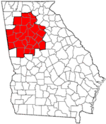
Major city Municipalities & communities 100k-250k 25k-100k Alpharetta • Brookhaven • Candler-McAfee • Duluth • Dunwoody • East Point • Gainesville • Johns Creek • Lawrenceville • Mableton • Marietta • Milton • Newnan • Peachtree City • Peachtree Corners • Redan • Smyrna • Tucker10k-25k Acworth • Belvedere Park • Buford • Carrollton • Cartersville • Chamblee • College Park • Conyers • Covington • Decatur • Doraville • Druid Hills • Douglasville • Fayetteville • Forest Park • Griffin • Kennesaw • Suwanee • Lilburn • Monroe • Mountain Park • North Decatur • North Druid Hills • Panthersville • Powder Springs • Riverdale • Snellville • Stockbridge • Sugar Hill • Union City • Vinings • Winder • WoodstockTopics Architecture • Culture • History • Media • Neighborhoods • People • Tourism • Transportation Georgia ·  United States
Municipalities and communities of Cobb County, Georgia County seat: Marietta Cities Acworth | Austell‡ | Kennesaw | Marietta | Powder Springs | Smyrna
CDPs Unincorporated
communitiesChattahoochee Plantation | Clarkdale | Cumberland | East Cobb | Powers Park | Spring Hill
Footnotes ‡This populated place also has portions in an adjacent county or counties
Historic Districts in Metro Atlanta Clayton County 
Cobb County Coweta County Grantville · Newnan: Cole Town · Greenville St.-LaGrange St. · Newnan Commercial · Newnan Cotton Mill and Mill Village · Northwest Newnan Residential · Platinum Point · Roscoe: Roscoe-Dunaway Gardens · Sargent · SenoiaDeKalb County Atlanta: Candler Park · Druid Hills · Inman Park-Moreland · Kirkwood · Avondale Estates · Brookhaven: · Oglethorpe University · Decatur: South Candler Street-Agnes Scott College ·Winnona Park · Druid Hills: Emory Grove · Emory University District · University Park-Emory Highlands-Emory Estate · Stone MountainDouglas County Fulton County Atlanta: Adair Park · Ansley Park · Atkins Park · Atlanta University Center · Berkeley Park · Brookhaven · Brookwood Hills · Cabbagetown · Castleberry Hill · Collier Heights · Druid Hills · Fairlie-Poplar · Fox Theatre Historic District · Garden Hills · Georgia Tech · Grant Park · Hotel Row · Howell Interlocking · Knight Park-Howell Station · Inman Park · Inman Park-Moreland · Knox Apts., Cauthorn House and Peachtree Rd. Apts. · Lakewood Heights · Martin Luther King, Jr., National Historic Site · Means St. · Midtown · Mozley Park · Oakland City · Peachtree Highlands-Peachtree Park · Pittsburgh · Reynoldstown · Southern Ry. North Ave. Yards · Sunset Ave. (proposed) · Sweet Auburn · Techwood Homes · Underground Atlanta · Virginia Highland · Washington Park · West End · Whittier Mills
College Park · East Point: Industrial District · Fairburn · Hapeville · RoswellGwinnett County Hall County Clermont · Flowery Branch · Gainesville: · Brenau College · Chicopee Mill and Village · Gainesville Commercial · Green Street · Green St.-Brenau · Gillsville · LulaNewton County Covington · Covington Mills and Mill Village · Floyd Street · Newborn · North Covington · Oxford · Porterdale · StarrsvilleRockdale County Categories:- Atlanta metropolitan area
- Cities in Georgia (U.S. state)
- Marietta, Georgia
- Populated places in Cobb County, Georgia
- County seats in Georgia (U.S. state)
- Populated places established in 1834


Wikimedia Foundation. 2010.