- Cumberland, Georgia
-
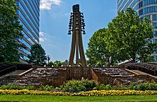
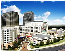
Cumberland — Community — The Cumberland skyline Coordinates: 33°54′53″N 84°29′35″W / 33.9148250°N 84.4929868°WCoordinates: 33°54′53″N 84°29′35″W / 33.9148250°N 84.4929868°W Elevation 225-320 m (738-1,050 ft) Population (2007) - Total 103,000 (approximately) Time zone EST (UTC-5) - Summer (DST) EDT (UTC-4) Website CumberlandCID.org Cumberland is a neighborhood and edge city in metro Atlanta, Georgia, United States. with approximately 122,000 workers and 103,000 residents. It is a major hub for business, convention, and retail in the region. Cumberland is situated ten miles (16 km) northwest of downtown Atlanta at the junction of I-75 and I-285 (the "Cobb Cloverleaf") in Cobb County. The area is marked by several modern skyscrapers rising from the wooded hills above the freeways. These towers house some of the area's 24 million square feet (over 2.2 million square meters) of office space, containing more office space than downtown Miami and making it metro Atlanta's fifth-largest commercial office district, after Downtown, Midtown, Buckhead, and Perimeter Center. Heavyweights such as Home Depot, and The Weather Channel are headquartered in Cumberland. It also houses some ten million square feet (930,000m²) of retail, with its focal point being the newly-renovated Cumberland Mall. Although small portions of Cumberland lay within Smyrna and Vinings, the majority of the area remains unincorporated with an Atlanta address.
Contents
History
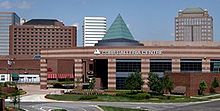
Cumberland has changed immensely over the past 50 years. In 1960, the area contained Camp Bert Adams, a Boy Scout reservation which still has a road bearing its name in the Vinings vicinity. Cumberland began most of its growth following World War II, but went into overdrive when Cumberland Mall opened as Georgia's largest mall and metro Atlanta's sixth enclosed, regional mall in 1973. A decade later, the first office tower of the Galleria was built on 86 acres (350,000 m2) of prime space in what became the heart of the Cumberland district. This paved the way for several other towers, retail strips and hotels. In 1988 property owners formed the Cumberland Community Improvement District (Cumberland CID), the first in Georgia.[1] The CID, a self-taxing district, has raised millions and has completed several infrastructure improvements in the area since its inception.[2][3][4] During the summer of 1994, the Cobb-Marietta Exhibit Hall and Coliseum Authority built the $48 million Cobb Galleria Centre by renovating the existing mall there, and it has become another success for the district.
A few small shopping centers were constructed in the mid-1990s, and a Cumberland Mall expansion and renovation was completed in 2006. Construction was completed on the Cobb Energy Performing Arts Centre in late 2007, adding nightlife to the area. The Atlanta Opera, founded in 1979, has moved its base to this location.
Future
There are many private projects in progress and/or proposed, including:
- Riverwood 200: At the corner of Cumberland Blvd and Cobb Parkway. 360 residential units and also a large amount of office and retail space including a 16 story office tower as an extension of the already existing Riverwood 100 complex. Ground has already broken on Riverwood. The project is led by Seven Oaks Company LLC and GE Asset Management. Architect is HOK.
- Park Vinings: Originally planned to be 110 $1 million + condo units, recent zoning submissions indicates that the change in the housing market and the currently saturated condo market in Atlanta has resulted in plans being changed for this property to house a 33 story retirement community with increased density than the original plans. [1] [2] [3] [4].
- Akers Mill Square redevelopment and refacing [5]
- Two mid-rise towers overlooking I-75 by Grove Street Partners LLC just south of the Cobb Energy Performing Arts Centre. One 18 and one 15 floor tower are approved by Cobb County. [6]
- Phase 2 of Overton Park owned by Hines Interests and being developed by Madison Retail LLC to add 60 condominium units and retail shops [7]
- Galleria: Day Capital Partners purchased 3 acres (12,000 m2) for $8.7 million directly adjoining the Cobb Galleria for future projects after 2010 when the current land lease runs out for the stores located on that property. The projects will likely include mixed retail/residential. [8]
- Crescent Ridge: 20-story office building and plaza on Cumberland Blvd next to the highway [9] [10]
- 2555 Cumberland: Two eight story office buildings overlooking 285 by the Shailendra Group. [11]
Most of the above plans have a public parking garage aspect included.
There are also planned public projects:
- Various "streetscapes" projects to improve the aesthetic appearance of streets, sidewalks and intersections including the installation of upscale lighting. [12][13]
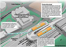
- Adding a I-75 North to 285 flyover. [14]
- Cobb transit station at Akers mill for either bus rapid transit or light rail. [15] [16]
- There is a planned Aker's Mill Trail that will connect to the Silver Comet Trail and the Chattahoochee River Trail. [17]
Geography
While there are no official boundaries (except for the CID, which is a 5 ½-square-mile area that includes the intersections of I-75, I-285 and U.S. Highway 41[5]), the business district generally extends as far northeast as the Wildwood Office Park on Powers Ferry Road, and up Cobb Parkway, the district's main street. Windy Hill Road is generally the northern extent of the district, except possibly for Terrell Mill Road. To the south and west, it extends down Cumberland Parkway and Paces Ferry roads.
Cumberland Boulevard encircles most of the area, and then continues northeast to Wildwood as Windy Ridge Parkway after crossing 41. Windy Ridge runs through the Interstate North office park, located immediately to the north of the interchange, and home to the Weather Channel. Interstate North Parkway runs parallel to 75 southeast to 285, then parallels it (and Powers Ferry) across the Chattahoochee River. Akers Mill Road starts in the east at Powers Ferry, is broken by a stretch of Cumberland Boulevard, then continues west across 41. Circle 75 Parkway begins at Windy Hill Road, opposite the I-75 southbound off-ramp, and parallels the road until turning southwest along I-285, becoming Spring Road at 41 (and then Concord Road at Atlanta Road in Smyrna).
The Cumberland district also borders the West Paces Ferry district of Buckhead in Atlanta and a portion of Sandy Springs, separated by the Chattahoochee River.
Notably, one of metro Atlanta's worst tornadoes made its first touchdown in the area, at Windy Hill Road and Cobb Parkway in April 1998. The Dunwoody tornado, as it came to be known for its major damage in Dunwoody, was captured on police video and later shown around the world as the two Cobb County Police officers drove southbound on 41 right through it, in order to escape the nighttime surprise.
Just a few miles or several kilometers east on the Perimeter at Georgia 400 and the boundary between Dunwoody and Sandy Springs is Perimeter Center, another similar edge city also created as a result of the Interstate Highway System and GDOT's choice of highway location in the 1960s. The Cumberland skyline can be easily seen in front of Atlanta's by looking southeast from atop Kennesaw Mountain.
Attractions
- Cumberland Mall
- Cobb Galleria Centre
- Cobb Energy Performing Arts Centre
- Chattahoochee River National Recreation Area
- Silver Comet Trail
References
Municipalities and communities of Cobb County, Georgia County seat: Marietta Cities CDPs Unincorporated
communitiesChattahoochee Plantation | Clarkdale | Cumberland | East Cobb | Powers Park | Spring Hill
Footnotes ‡This populated place also has portions in an adjacent county or counties
Metro Atlanta Counties 
Major city Municipalities & communities 100k-250k Cumberland • East Cobb • Roswell • Sandy Springs25k-100k Alpharetta • Brookhaven • Candler-McAfee • Duluth • Dunwoody • East Point • Gainesville • Johns Creek • Lawrenceville • Mableton • Marietta • Milton • Newnan • Peachtree City • Peachtree Corners • Redan • Smyrna • Tucker10k-25k Acworth • Belvedere Park • Buford • Carrollton • Cartersville • Chamblee • College Park • Conyers • Covington • Decatur • Doraville • Druid Hills • Douglasville • Fayetteville • Forest Park • Griffin • Kennesaw • Suwanee • Lilburn • Monroe • Mountain Park • North Decatur • North Druid Hills • Panthersville • Powder Springs • Riverdale • Snellville • Stockbridge • Sugar Hill • Union City • Vinings • Winder • WoodstockTopics Architecture • Culture • History • Media • Neighborhoods • People • Tourism • Transportation Georgia ·  United StatesCategories:
- Atlanta metropolitan area
- Geography of Atlanta, Georgia
- Populated places in Cobb County, Georgia
- Geography of Georgia (U.S. state)
- Unincorporated communities in Georgia (U.S. state)
Wikimedia Foundation. 2010.


