- Montgomery County, Georgia
-
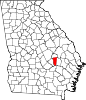
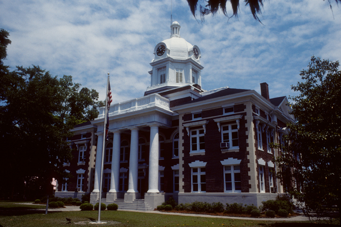
Montgomery County, Georgia  Montgomery County Courthouse (Built 1907), Mount Vernon, Georgia
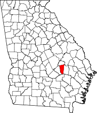
Location in the state of Georgia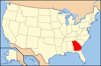
Georgia's location in the U.S.Founded December 19, 1793 Named for Richard Montgomery Seat Mount Vernon Largest city Mount Vernon Area
- Total
- Land
- Water
247.32 sq mi (641 km²)
245.33 sq mi (635 km²)
1.99 sq mi (5 km²),Population
- (2000)
- Density
8,909
34/sq mi (13/km²)Time zone Eastern: UTC-5/-4 Montgomery County is a county in the U.S. state of Georgia. As of 2000, the population was 8,270. The 2007 Census Estimate shows a population of 9,060.[1] The county seat is Mount Vernon.[2]
Montgomery County is part of the Vidalia Micropolitan Statistical Area.
Contents
History
Montgomery County is named in honor of Richard Montgomery, an American Revolutionary War general killed in 1775 while attempting to capture Quebec City, Canada. It was created on December 19, 1793.
More recently, the county is noted for its practice of organizing segregated proms, a practice that has continued since integration of its schools in the 1970s.[3][4][5]
Geography
According to the 2000 census, the county has a total area of 247.32 square miles (640.6 km2), of which 245.33 square miles (635.4 km2) (or 99.20%) is land and 1.99 square miles (5.2 km2) (or 0.80%) is water.[6]
Major highways
 U.S. Highway 221
 U.S. Highway 280
 Georgia State Route 29
 Georgia State Route 56
 Georgia State Route 135
 Georgia State Route 199
Adjacent counties
- Treutlen County (north)
- Toombs County (east)
- Jeff Davis County (south)
- Wheeler County (west)
Demographics
As of the census[7] of 2000, there were 8,270 people, 2,919 households, and 2,063 families residing in the county. The population density was 13/km² (34/mi²). There were 3,492 housing units at an average density of 6/km² (14/mi²). The racial makeup of the county was 69.72% White, 27.24% Black or African American, 0.07% Native American, 0.19% Asian, 0.02% Pacific Islander, 2.13% from other races, and 0.62% from two or more races. 3.28% of the population were Hispanic or Latino of any race.
There were 2,919 households out of which 34.00% had children under the age of 18 living with them, 53.10% were married couples living together, 13.50% had a female householder with no husband present, and 29.30% were non-families. 25.60% of all households were made up of individuals and 10.20% had someone living alone who was 65 years of age or older. The average household size was 2.57 and the average family size was 3.08.
In the county the population was spread out with 25.00% under the age of 18, 12.80% from 18 to 24, 30.20% from 25 to 44, 21.40% from 45 to 64, and 10.60% who were 65 years of age or older. The median age was 34 years. For every 100 females there were 105.10 males. For every 100 females age 18 and over, there were 105.50 males.
The median income for a household in the county was $30,240, and the median income for a family was $38,418. Males had a median income of $27,572 versus $21,342 for females. The per capita income for the county was $14,182. About 15.80% of families and 19.90% of the population were below the poverty line, including 24.70% of those under age 18 and 23.90% of those age 65 or over.
Cities and towns
See also

Treutlen County Wheeler County 
Toombs County  Montgomery County, Georgia

Jeff Davis County Municipalities and communities of Montgomery County, Georgia Cities Ailey | Mount Vernon | Uvalda | Vidalia‡
Towns Village Footnotes ‡This populated place also has portions in an adjacent county or counties
Coordinates: 32°10′N 82°32′W / 32.17°N 82.53°W
References
- ^ http://www.census.gov/popest/counties/tables/CO-EST2007-01-13.xls census.gov
- ^ "Find a County". National Association of Counties. http://www.naco.org/Counties/Pages/FindACounty.aspx. Retrieved 2011-06-07.
- ^ Shapiro, Dana (May 2003). "Separate but equal?". Spin (magazine). http://books.google.com/books?id=CleCKauyN34C&pg=PA94#v=onepage&q=&f=false. Retrieved March 22, 2010.
- ^ Sara Corbett (May 21, 2009). "A Prom Divided". The New York Times. http://www.nytimes.com/2009/05/24/magazine/24prom-t.html?_r=1&hp.
- ^ Leonard Doyle (June 21, 2009). "Segregated high school proms divide Georgia's students". The Daily Telegraph. http://www.telegraph.co.uk/news/worldnews/northamerica/usa/5586617/Segregated-high-school-proms-divide-Georgias-students.html. Retrieved March 17, 2010.
- ^ "Census 2000 U.S. Gazetteer Files: Counties". United States Census. http://www.census.gov/tiger/tms/gazetteer/county2k.txt. Retrieved 2011-02-13.
- ^ "American FactFinder". United States Census Bureau. http://factfinder.census.gov. Retrieved 2008-01-31.
Categories:- Georgia (U.S. state) counties
- Montgomery County, Georgia
- 1793 establishments
- Vidalia micropolitan area


Wikimedia Foundation. 2010.