- Cook County, Georgia
-
Cook County, Georgia 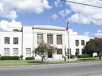 Cook County Courthouse in Adel, Georgia
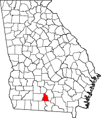
Location in the state of Georgia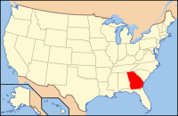
Georgia's location in the U.S.Founded 1918 Seat Adel Largest city Adel Area
- Total
- Land
- Water
233.22 sq mi (604 km²)
229.02 sq mi (593 km²)
4.20 sq mi (11 km²), 1.80%Population
- (2010)
- Density
17,212
27/sq mi (69/km²)Congressional district 1st Time zone Eastern: UTC-5/-4 Website http://www.cookcountyga.com/ Cook County is a county located in the U.S. state of Georgia. The constitutional amendment to create the county was proposed July 30, 1918, and ratified November 5, 1918. As of 2010, the population is 17,212.[1] The county seat is Adel.[2] Cook County is named for former Civil War general Philip Cook of the Confederate States Army.
Reed Bingham State Park is in Cook County.
Contents
Geography
According to the 2000 census, the county has a total area of 233.22 square miles (604.0 km2), of which 229.02 square miles (593.2 km2) (or 98.20%) is land and 4.20 square miles (10.9 km2) (or 1.80%) is water.[3]
Major highways
 Interstate 75
 U.S. Route 41
 State Route 7
 State Route 37
 State Route 76
Adjacent counties
- Tift County (north)
- Berrien County (east)
- Lowndes County (southeast)
- Brooks County (southwest)
- Colquitt County (west)
Demographics
As of the census[4] of 2000, there were 15,771 people, 5,882 households, and 4,282 families residing in the county. The population density was 69 people per square mile (27/km²). There were 6,558 housing units at an average density of 29 per square mile (11/km²). The racial makeup of the county was 67.93% White, 29.09% Black or African American, 0.22% Native American, 0.42% Asian, 0.03% Pacific Islander, 1.53% from other races, and 0.78% from two or more races. 3.08% of the population were Hispanic or Latino of any race.
There were 5,882 households out of which 34.80% had children under the age of 18 living with them, 53.30% were married couples living together, 15.30% had a female householder with no husband present, and 27.20% were non-families. 24.00% of all households were made up of individuals and 10.50% had someone living alone who was 65 years of age or older. The average household size was 2.64 and the average family size was 3.12.
In the county the population was spread out with 28.20% under the age of 18, 9.10% from 18 to 24, 27.90% from 25 to 44, 21.80% from 45 to 64, and 13.00% who were 65 years of age or older. The median age was 34 years. For every 100 females there were 92.10 males. For every 100 females age 18 and over, there were 89.50 males.
The median income for a household in the county was $27,582, and the median income for a family was $31,820. Males had a median income of $26,262 versus $19,703 for females. The per capita income for the county was $13,465. About 16.50% of families and 20.70% of the population were below the poverty line, including 27.90% of those under age 18 and 24.40% of those age 65 or over.
Cities and towns
Education
Main article: Adel, Georgia#EducationSee also
References
- ^ "American FactFinder". United States Census Bureau. http://factfinder2.census.gov. Retrieved 2011-05-14.
- ^ "Find a County". National Association of Counties. http://www.naco.org/Counties/Pages/FindACounty.aspx. Retrieved 2011-06-07.
- ^ "Census 2000 U.S. Gazetteer Files: Counties". United States Census. http://www.census.gov/tiger/tms/gazetteer/county2k.txt. Retrieved 2011-02-13.
- ^ "American FactFinder". United States Census Bureau. http://factfinder.census.gov. Retrieved 2008-01-31.
External links

Tift County Colquitt County 
Berrien County  Cook County, Georgia

Brooks County Lowndes County Municipalities and communities of Cook County, Georgia City 
Towns Categories:- Georgia (U.S. state) counties
- Cook County, Georgia
- 1918 establishments in the United States
- Populated places established in 1918


Wikimedia Foundation. 2010.