- Creola, Alabama
-
Creola — City — 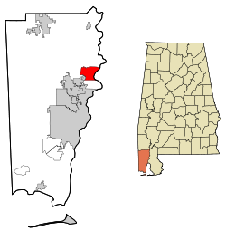
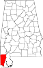
Coordinates: 30°53′43″N 88°0′53″W / 30.89528°N 88.01472°W Country United States State Alabama County Mobile Area – Total 15.5 sq mi (40.1 km2) – Land 14.6 sq mi (37.8 km2) – Water 0.9 sq mi (2.3 km2) Elevation 23 ft (7 m) Population (2000) – Total 2,002 – Density 129.2/sq mi (49.9/km2) Time zone Central (CST) (UTC-6) – Summer (DST) CDT (UTC-5) ZIP code 36525 Area code(s) 251 FIPS code 01-18304 GNIS feature ID 0116848 Creola is a city[1] in Mobile County, Alabama, United States. The population was 2,002 at the 2000 census, at which time it was still a town. It is included in the Mobile metropolitan statistical area.
Contents
Geography
Creola is located at 30°53′44″N 88°0′53″W / 30.89556°N 88.01472°W (30.895465, -88.014760)[2].
According to the U.S. Census Bureau, the town had a total area of 15.5 square miles (40 km2), of which, 14.6 square miles (38 km2) of it is land and 0.9 square miles (2.3 km2) of it (5.62%) is water.
Demographics
As of the census[3] of 2000, there were 2,002 people, 718 households, and 567 families residing in the town. The population density was 137.1 people per square mile (52.9/km2). There were 796 housing units at an average density of 54.5 per square mile (21.0/km2). The racial makeup of the town was 86.36% White, 9.89% Black or African American, 1.45% Native American, 0.10% Asian, 0.35% from other races, and 1.85% from two or more races. 0.65% of the population were Hispanic or Latino of any race.
There were 718 households out of which 40.7% had children under the age of 18 living with them, 59.9% were married couples living together, 14.8% had a female householder with no husband present, and 20.9% were non-families. 17.1% of all households were made up of individuals and 5.8% had someone living alone who was 65 years of age or older. The average household size was 2.79 and the average family size was 3.15.
In the town the population was spread out with 29.2% under the age of 18, 9.6% from 18 to 24, 29.7% from 25 to 44, 22.3% from 45 to 64, and 9.2% who were 65 years of age or older. The median age was 34 years. For every 100 females there were 93.8 males. For every 100 females age 18 and over, there were 95.9 males.
The median income for a household in the town was $35,517, and the median income for a family was $38,942. Males had a median income of $35,658 versus $19,911 for females. The per capita income for the town was $14,956. About 14.3% of families and 16.0% of the population were below the poverty line, including 18.5% of those under age 18 and 19.9% of those age 65 or over.
Education
Mobile County Public School System operates public schools. Students are zoned to North Mobile County Middle School.[4]
On September 7, 2010 North Mobile County Middle School opened, replacing the role of Adams Middle School in Saraland, because residents outside of Saraland are no longer zoned to Adams Middle.[5]
References
- ^ U.S. Census change list
- ^ "US Gazetteer files: 2010, 2000, and 1990". United States Census Bureau. 2011-02-12. http://www.census.gov/geo/www/gazetteer/gazette.html. Retrieved 2011-04-23.
- ^ "American FactFinder". United States Census Bureau. http://factfinder.census.gov. Retrieved 2008-01-31.
- ^ "Welcome to North Mobile County Middle School." North Mobile County Middle School. Retrieved on October 22, 2010. "The North Mobile County Middle School serves students living outside the Saraland City Limits and includes students from Satsuma, Creola, Axis, and Prichard. We will be located at the current Lee Intermediate Building and will be located here until a new facility is completed on Salco Road."
- ^ Phillips, Rena Havner. "Video: North Mobile County Middle School opens its doors in Axis." Mobile Press-Register. Tuesday September 7, 2010. Retrieved on October 22, 2010. "North Mobile County Middle School students 6th grader Derrick Boykin, 12, and 7th grader Amanda Daniels, 12, walk down a sidewalk on the first day of classes at the school Tuesday, Sept. 7, 2010. The newly completed $14 million school was built to accommodate students displaced by Saraland's split from the Mobile County system. "
Coordinates: 30°53′44″N 88°00′53″W / 30.895465°N 88.01476°W
Municipalities and communities of Mobile County, Alabama Cities Bayou La Batre | Chickasaw | Citronelle | Creola | Mobile | Prichard | Saraland | Satsuma | Semmes
Towns CDPs Axis | Belle Fontaine | Bucks | Calvert | Chunchula | Grand Bay | Theodore | Tillmans Corner
Unincorporated
communitiesGhost town Categories:- Populated places in Mobile County, Alabama
- Cities in Alabama


Wikimedia Foundation. 2010.