- California State Route 67
Infobox road
state=CA
type=SR
route=67
alternate_name=San Vincente Freeway
section=367
maint=Caltrans 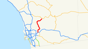
length_mi=24.38
length_round=2
length_ref= [ [http://www.dot.ca.gov/hq/structur/strmaint/brlog2.htm January 1, 2006 California Log of Bridges on State Highways] ]
direction_a=South
terminus_a=jct|state=CA|I|8 in El Cajon
direction_b=North
terminus_b=jct|state=CA|SR|78 in Ramona
previous_type=SR
previous_route=66
next_type=SR
next_route=68State Route 67 runs from Interstate 8 in El Cajon to Lakeside as the San Vincente Freeway. It then becomes a smaller roadway through Poway and becomes Main St in Ramona before ending into State Route 78.
In
2004 it was planned that Route 67 will be upgraded tofreeway grade a little bit farther up through Lakeside, but there are no plans yet to continue even further. In1964 it was planned to be the eastern terminus of State Route 56, and this plan may have been canceled as well.This route is part of the
California Freeway and Expressway System [http://www.leginfo.ca.gov/cgi-bin/displaycode?section=shc&group=00001-01000&file=250-257 CA Codes (shc:250-257)] ] .Other names
*CHP Officer Christopher D. Lydon Memorial Freeway: From Interstate 8 to Mapleview Street in Lakeside. [cite book | url=http://www.dot.ca.gov/hq/tsip/hseb/products/Named_Freeways.pdf | title=2007 Named Freeways, Highways, Structures and Other Appurtenances in California | publisher=
Caltrans | pages=67 | accessdate=2007-03-28]Major intersections and exit list
:"Note: Except where prefixed with a letter,
postmile s were measured in 1964, based on the alignment as it existed at that time, and do not necessarily reflect current mileage."The entire route is in San Diego County.References
External links
* [http://www.westcoastroads.com/california/ca-067.html California @ WestCoastRoads.com - State Route 67]
* [http://www.dot.ca.gov/hq/roadinfo/sr67 Caltrans: Route 67 highway conditions]
* [http://www.cahighways.org/065-072.html#067 California Highways - State Route 67]

Wikimedia Foundation. 2010.