- California State Route 94
-
State Route 94
Route information Defined by S&HC § 394 Maintained by Caltrans Length: 63.324 mi[1] (101.910 km) Major junctions West end:  I-5 in San Diego
 SR 125 in Spring Valley
 SR 188 near Tecate
East end:  I-8 near Boulevard
Highway system State highways in California(list • pre-1964)
History • Unconstructed • Deleted • Freeway • Scenic←  SR 92
SR 92US 95  →
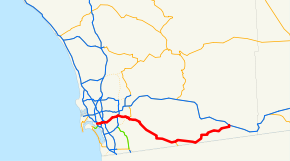
→State Route 94 (SR 94) in the U.S. state of California is the Martin Luther King Jr. Freeway from Interstate 5 in Downtown San Diego to the end of the freeway portion past Route 125 in Spring Valley; the non-freeway segment of SR 94 is Campo Road.
Contents
Route description
This route is part of the California Freeway and Expressway System[2] and is eligible for the State Scenic Highway System[3]. However, it is not a scenic highway as designated by Caltrans.[4]
SR 94 is an east–west running freeway that connects the communities of downtown San Diego (becoming the one-way F Street at freeway's westbound terminus at 17th Street; eastbound traffic enters the freeway from the one-way G Street), southeast San Diego, Lemon Grove, La Mesa, Spring Valley, Casa de Oro. The route turns into a highway at Via Mercado in Rancho San Diego. Route 94 continues through Rancho San Diego by keeping right at the Jamacha Road and Campo Road intersection. The remainder of the route connects the communities of Jamul, Dulzura, Tecate, Potrero, Campo, and Boulevard. The route ends at the east end by connecting to Interstate 8.
Perhaps due to its namesake, this highway served as part of the route of the hearse that carried the body of Coretta Scott King from San Diego to Atlanta.[citation needed]
History
Prior to the 1990s construction of additional sections of Route 125 to the south of Route 94 and to the north of Interstate 8, the section of Route 125 between Route 94 and Interstate 8 was signed as part of Route 94 (even though both the sections of the current Route 94 west and east of Route 125 were also signed as Route 94). Signage at the interchange of Interstate 8 and Route 125 was later modified to add the Route 125 designation and a "TO" referring to the Route 94 signage (still present), while signs on the freeway itself were changed to Route 125 north and south, as appropriate. The signage changes were made shortly before the opening of the portion of Route 125 immediately north of Interstate 8. One relic of this alignment is that the primary traffic lanes of eastbound Route 94 lead to northbound Route 125, while southbound lanes of Route 125 lead to westbound Route 94, requiring the use of interchange ramps to continue on the route and direction prior to this interchange.
Major intersections
- Note: Except where prefixed with a letter, postmiles were measured in 1964, based on the alignment as it existed at that time, and do not necessarily reflect current mileage.
The entire route is in San Diego County.
Location Postmile
[5][6][7]Exit
[8]Destinations Notes San Diego 1.42 I-5 south – Balboa Park, Downtown San DiegoWestbound exit and eastbound entrance 1.42 1A I-5 north (San Diego Freeway) – Los AngelesWestbound exit and eastbound entrance 1.85 1B 25th Street Westbound exit and eastbound entrance 2.21 1C 28th Street Signed as exit 1 eastbound 2.68 1D 32nd Street, Broadway No eastbound exit 3.17 2  SR 15 (Escondido Freeway)
Signed as exits 2A (south) and 2C (north) eastbound; westbound exit to SR 15 north is via exit 3 3.63 2B Home Avenue Eastbound exit and westbound entrance 4.09 3  I-805 (Jacob Dekema Freeway)
Eastbound exit to I-805 north is via exit 2C 4.63 47th Street Entrance ramps only 5.14 4A Euclid Avenue Signed as exit 4 westbound 5.79 4B Kelton Road Signed as exit 5 westbound 6.16 5 Federal Boulevard Westbound exit is via a U-turn at exit 5 7.29 6A College Grove Way Westbound exit and entrance Lemon Grove 7.76 6B College Avenue, Broadway Signed as exit 6 eastbound; no eastbound entrance 8.27 7 Massachusetts Avenue 8.93 8 Lemon Grove Avenue T10.11 9 SR 125Signed as exits 9A (south) and 9B (north) La Mesa R10.88 9C Spring Street – La Mesa Spring Valley R11.08 10A Bancroft Drive – Casa de Oro R11.80 10B Kenwood Drive – Casa de Oro R12.75 11 Sweetwater Springs Boulevard – Casa de Oro R13.33 12 Avocado Boulevard, Calavo Drive East end of freeway 14.33  CR S17 (Jamacha Boulevard)
14.86  SR 54 east (Jamacha Road)
19.40 Indian Springs Drive, Lyons Valley Road – Lawson Valley, Lyons Valley 24.57 Otay Lakes Road – Otay Lakes, Chula Vista, National City 38.97 SR 188 south – Tecate, Ensenada52.15  CR S1 (Buckman Springs Road)
64.23 Old Highway 80 – Live Oak Springs, San Diego Former US 80 west Boulevard 64.82 Old Highway 80, Jewel Valley Road – Jacumba Old Highway 80 was former US 80 east 65.38 I-8 – El Centro, San DiegoInterchange 65.38 Ribbonwood Road Continuation beyond I-8 1.000 mi = 1.609 km; 1.000 km = 0.621 mi
Concurrency terminus • Closed/Former • Incomplete access • UnopenedReferences
- ^ January 1, 2006 California Log of Bridges on State Highways
- ^ CA Codes (shc:250-257)
- ^ CA Codes (shc:260-284)
- ^ "Officially Designated State Scenic Highways and Historic Parkways". California Department of Transportation. December 7, 2007. http://www.dot.ca.gov/hq/LandArch/scenic_highways/. Retrieved June 23, 2011.
- ^ California Department of Transportation, State Truck Route List (XLS file), accessed February 2008
- ^ California Department of Transportation, Log of Bridges on State Highways, July 2007
- ^ California Department of Transportation, All Traffic Volumes on CSHS, 2005 and 2006
- ^ California Department of Transportation, California Numbered Exit Uniform System, SR-94 Eastbound and SR-94 Westbound, accessed February 2008
External links
Categories:- State highways in California
- Southern California freeways
- Roads in San Diego County, California


Wikimedia Foundation. 2010.