- California State Route 15
Infobox road
state=CA
type=SR
route=15
alternate_name=Escondido Freeway
section=315
maint=Caltrans 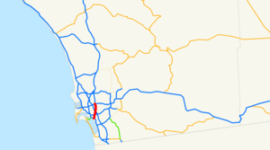
length_mi=5.59
length_ref= [http://www.dot.ca.gov/hq/structur/strmaint/brlog2.htm January 1, 2006 California Log of Bridges on State Highways] ]
length_round=2
established=1969 (from SR 103) [ [http://cahighways.org/009-016.html#015 California Highways: Interstate 15] ]
direction_a=South
terminus_a=jct|state=CA|I|5|road=Main Street, Harbor Drive in San Diego
direction_b=North
terminus_b=jct|state=CA|I|8|I|15 in San Diego
previous_type=I
previous_route=15
next_type=SR
next_route=16State Route 15 in the
U.S. state ofCalifornia is the seamless 5.59-mile (9.00 km)freeway continuation of Interstate 15 past its southern terminus at Interstate 8 inSan Diego to the Interstate 5 junction 12 miles from the Mexican border. The Route 15 designation is also used byCaltrans for the full length of I-15.This route is part of the
California Freeway and Expressway System [http://www.leginfo.ca.gov/cgi-bin/displaycode?section=shc&group=00001-01000&file=250-257 CA Codes (shc:250-257)] ] .Route description
SR 15 continues seamlessly past the southern terminus of I-15 at I-8 in San Diego. On the northbound conversion to I-15 at I-8, there is no "End SR 15" sign [cite web |url=http://www.westcoastroads.com/california/i-015a_ca.html |title=California @ WestCoastRoads - California 15 and Interstate 15 north from Interstate 5 to California 163 |accessdate=2008-05-01] . Between I-8 and I-805, SR 15 follows the former alignment of 40th Street, which was its former routing as a city street. Cite map | publisher=Thomas Brothers | title=California Road Atlas and Driver's Guide | year=2000 | page=214, 216] .Between the Polk Avenue and Orange Avenue overpasses, the freeway goes under a city park that was built on top of the freeway during construction in 2001. Pedestrian bridges were also built at Monroe Avenue and Landis Street to reduce the effects of the freeway geographically dividing the community [ [http://www.dot.ca.gov/dist11/facts/15-40th.htm Caltrans District 11 Fact Sheet for SR-15 Project] ] . The route interchanges with Interstate 805; however, one can only continue in the same direction that they were at this intersection, since this is the interchange of two north-south freeways, resulting in the overall shape of an "X." After this, SR 15 has an interchange with State Route 94, which has been cited as not being up to Interstate standards [cite web |url=http://cahighways.org/009-016.html#015 |title=California Highways: Routes 9 through 16 |accessdate=2008-05-01] . Then, SR 15 terminates south of Interstate 5 at Wabash Boulevard.
History
Present SR 15 was signed after the creation of I-15 in 1968. Since I-15's terminus was at I-8, SR 15 was signed mostly along 40th Street and Wabash Boulevard in San Diego to its merge with I-5. The portion between Adams Avenue and Interstate 805 remained a city street for a long time, and this portion was not completed until January
2000 . For this reason, the freeway is oftenFact|date=July 2008 referred to as the 40th Street Freeway.Before the completion of the freeway, from
1968 to1992 , the neighborhood was known for prostitution, drugs, drive-by shootings, and gangs. The indirect cause of all this was due toCaltrans ' plans to build a freeway in this area on land where houses were. Because families did not want to live in these houses since they would be soon torn down, they rented them to those who were only going to be in the area on a temporary basis; many of these people were involved in illegal activities. Even though the freeway was officially added to theCaltrans proposals as early as 1968, it was not until March 1992 that construction began. Many in the city opposed the building of this freeway, although some petitioned for the freeway to be built because of the poor conditions in the neighborhood.cite news |first= Jeanne F.|last=Brooks|title=A neighborhood's rough road: Mid city's I-15 stretch to open after tortuous 40-year saga |url=http://proquest.umi.com/pqdweb?index=7&did=74641436&SrchMode=1&sid=2&Fmt=3&VInst=PROD&VType=PQD&RQT=309&VName=PQD&TS=1200630104&clientId=62473|format=Fee required, reprint |work=The San Diego Union-Tribune |publisher= Copley News Service|date=2000-01-09 |accessdate=2008-01-18 ]Future
Redesignation of SR 15 as I-15 will eventually occur when the freeway's interchange with SR 94 is updated to
Interstate standards . The interchange currently has left-exits and blind merges, and is due to be updated with a long-awaited widening of both SR 15 and SR 94 in 2008. At that time SR 15 will be resigned as part of I-15. The remaining portion of SR 15 conforms with Interstate standards. [cite web |url=http://cahighways.org/009-016.html#015 |title=California Highways: Routes 9 through 16 |accessdate=2008-05-01]Exit list
:"Note: Except where prefixed with a letter,
postmile s were measured in 1964, based on the alignment as it existed at that time, and do not necessarily reflect current mileage."The entire route is in San Diego, San Diego County.References
External links
* [http://cahighways.org/009-016.html#015 California Highways: Interstate 15]
* [http://www.westcoastroads.com/california/i-015_ca.html California @ WestCoastRoads - Interstate 15]
* [http://www.interstate-guide.com/i-015.html Interstate 15 @ Interstate-Guide.com]

Wikimedia Foundation. 2010.