- Interstate 8 in California
Infobox road
state=CA
type=I
route=8
section=308
maint=Caltrans 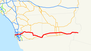
length_mi=172
length_round=0
length_ref= [http://www.fhwa.dot.gov/reports/routefinder/table1.htm Route Log- Main Routes of the Eisenhower National System of Interstate and Defense Highways - Table 1] ]
established=1964 (from US 80)
direction_a=West
terminus_a=Sunset Cliffs Blvd. in Ocean Beach
junction=jct|state=CA|I|5 in San Diego
jct|state=CA|SR|67 in El Cajon
jct|state=CA|SR|111 near El Centro
direction_b=East
terminus_b=jct|state=AZ|I|8 inYuma, AZ
previous_type=SR
previous_route=7
next_type=SR
next_route=9
commons=categoryIn theU.S. state ofCalifornia ,Interstate 8 is designated for convert|172|mi|km|0|sp=us|lk=on|abbr=on, from Sunset Cliffs Boulevard inSan Diego to the California-Arizona state line. The highway is a major commuter route in theSan Diego Metropolitan Area and the primary east-west throughfare. It serves the cities of San Diego, La Mesa, El Cajon, and El Centro. It is officially known as the Border Friendship Route from San Diego to the Arizona state line. [cite book | url=http://www.dot.ca.gov/hq/tsip/hseb/products/Named_Freeways.pdf | title=2007 Named Freeways, Highways, Structures and Other Appurtenances in California | publisher=Caltrans | pages=120 | accessdate=2007-10-18] It is also signed as the Ocean Beach Freeway west of Interstate 5 and as theKumeyaay Highway (after the local Native American tribe) in the non-incorporated areas of eastern San Diego County.This route is part of the
California Freeway and Expressway System [http://www.leginfo.ca.gov/cgi-bin/displaycode?section=shc&group=00001-01000&file=250-257 CA Codes (shc:250-257)] ] and is eligible for the State Scenic Highway System [http://www.leginfo.ca.gov/cgi-bin/displaycode?section=shc&group=00001-01000&file=260-284 CA Codes (shc:260-284)] ] .Route description
Interstate 8 begins at the intersection of Sunset Cliffs Boulevard and Nimtz Boulevard. For its first few miles, it parallels the San Diego River Floodway east. Near Old Town, I-8 intersects with Interstate 5 as well as with the former State Route 209. I-8 continues eastward, bisecting the area known as "Hotel Circle." As I-8 enters Mission Valley, it has junctions with State Route 163, Interstate 805, and Interstate 15 and its continuation, State Route 15. In La Mesa, I-8 interchanges with State Route 125. I-8 continues into El Cajon, where it intersects with State Route 67 before it ascends into the mountains and the
Cleveland National Forest , traveling through towns such as Alpine and Pine Valley. I-8 intersects with State Route 79 in the national forest before descending into the Imperial Valley and passing through the La Posta and CampoIndian reservation s. In Boulevard, I-8 intersects with the eastern end of State Route 94.Cite map | publisher=Rand McNally | title=The Road Atlas | year=2008 | page=15,17 ] Cite map | publisher=Thomas Brothers | title=California Road Atlas and Driver's Guide | year=2000 | page=107,111,112,212,213,214,V]Interstate 8 straddles the San Diego-Imperial county line for a few miles before turning east. While going over the mountain pass into the Imperial Valley, I-8's roadways are separated by a considerable distance. This is because the eastbound lanes traverse the pass on the former roadbed of US-80. The westbound lanes were placed on a different routing, and the result is the grade-separated crossing of the eastbound and westbound lanes [http://www.cahighways.org/001-008.html#008 California Highways] ] . In the Imperial Valley, I-8 intersects with State Route 98, a highway leading to Calexico. I-8 then goes through Coyote Wells before entering the city of El Centro several miles later. In El Centro, I-8 intersects with State Route 86 and State Route 111, both north-south routes which connect to Interstate 10 in the
Coachella Valley (north of theSalton Sea ), before State Route 115 and State Route 98 merge with I-8. The freeway then traverses theImperial Sand Dunes Recreation Area and intersects with State Route 186 leading toMexico . Interstate 8 then passes through Winterhaven before crossing theColorado River intoYuma, Arizona on a bridge built in 1978.History
Interstate 8 was originally signed as U.S. Route 80 from around 1929 until 1964. However, the original designations of US-80 in California were as LRN 12 (since 1909) from San Diego to El Centro, and as LRN 27 (since 1915) from El Centro to Arizona. I-8 was accepted as a chargeable interstate in 1957, and was signed as Interstate 8 in 1964 [http://www.gbcnet.com/ushighways/history/1964_hwy_renumbering_contents.html 1964 California Highway Renumbering] ] . The "Ocean Beach Highway" section west of I-5 was completed by 1967 [http://www.westcoastroads.com/california/i-008_ca.html WestCoastRoads] ] as LRN 286 and was later designated as SR 109; it was later added to Interstate 8 in 1972.
Exit list
:"Note: Except where prefixed with a letter,
postmile s were measured in 1964, based on the alignment as it existed at that time, and do not necessarily reflect current mileage. The numbers reset at county lines; the start and end postmiles in each county are given in the county column."References
External links
* [http://www.cahighways.org/001-008.html California Highways, Routes 1 through 8] , CaHighways.org
* [http://www.floodgap.com/roadgap/209/ Old SR 209 and the Cabrillo National Monument] , Floodgap.com

Wikimedia Foundation. 2010.