California State Route 209
- California State Route 209
Infobox road
state=CA
type=CA
route=209
length_mi=8
length_round=0
length_ref=
history=State highway in 1933; numbered in 1964; deleted in 2003
direction_a=South
terminus_a=Cabrillo National Monument
direction_b=North
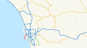
terminus_b=jct|state=CA|I|5|I|8 in San DiegoState Route 209 was a state highway in the U.S. state of California, connecting Point Loma with the interchange of I-5 and I-8 in San Diego. The route began at the Cabrillo National Monument and passed through Fort Rosecrans and the neighborhood of Point Loma via Catalina Boulevard, Canon Street, and Rosecrans Street.
This route was deleted in 2003. As signs get replaced on I-5, references to Route 209 are disappearing; however, Route 209 is still well marked on Rosecrans. [cite web |url=http://www.cahighways.org/209-216.html#209 |title=Routes 209 through 216 |accessdate=2008-05-01 |last=Faigin |first=Daniel]
Major intersections
:"Note: Except where prefixed with a letter, postmiles were measured in 1964, based on the alignment as it existed at that time, and do not necessarily reflect current mileage."The entire route is in San Diego, San Diego County.
References
Wikimedia Foundation.
2010.
Look at other dictionaries:
California State Route 209 — Karte … Deutsch Wikipedia
California State Route 99 — Infobox road state=CA type=SR route=99 section=399 maint=Caltrans length mi=424.85 length ref= [http://www.dot.ca.gov/hq/structur/strmaint/brlog2.htm January 1, 2006 California Log of Bridges on State Highways] ] length round=2 length… … Wikipedia
California State Route 211 — Infobox road state=CA type=SR route=211 section=511 alternate name=Main Street, Fernbridge Drive maint=Caltrans length mi=5.395 length round=3 length ref= direction a=South terminus a=Ocean Avenue in Ferndale direction b=North terminus… … Wikipedia
Washington State Route 20 — State Route 20 Whidbey Scenic Isle Way North Cascades Highway … Wikipedia
New York State Route 52 — This article is about the current alignment of NY 52. For the former alignment of NY 52 in the Finger Lakes region, see New York State Route 52 (1920s–1930). NYS Route 52 … Wikipedia
State Scenic Highway System (California) — infobox road state=CA marker highway name=State Scenic Highway SystemThe State Scenic Highway System is a list of highways, mainly state highways, that have been designated by the California Department of Transportation (Caltrans) as scenic… … Wikipedia
List of highways numbered 209 — The following highways are numbered 209: Canada Nova Scotia Route 209 Quebec Route 209 Saskatchewan Highway 209 India National Highway 209 (India) United States U.S. Route 209 … Wikipedia
Liste der State-, U.S.- und Interstate-Highways in Kalifornien — Dies ist eine Aufstellung von State Highways in Kalifornien, USA nach Nummern. Inhaltsverzeichnis 1 State Routes 2 Interstates 2.1 Zubringer und Umgehungen 3 U.S. Highways … Deutsch Wikipedia
State highways in Colorado — The standard Colorado state highway sign. The top half is the flag of Colorado. Highway names Interstates: Interstate X (I X) US Routes: U.S. Highway X (US X) … Wikipedia
Deleted state highways in California — Standard route signage in California … Wikipedia
