- California State Route 9
Infobox road
state=CA
type=SR
route=9
section=309
maint=Caltrans 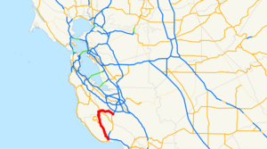
length_mi=38.49
length_ref= [http://www.dot.ca.gov/hq/structur/strmaint/brlog2.htm January 1, 2006 California Log of Bridges on State Highways] ]
length_round=2
established=1934 [http://cahighways.org/009-016.html#009 California Highways: State Route 9] ]
direction_a=South
terminus_a=jct|state=CA|SR|1 in Santa Cruz
junction=jct|state=CA|SR|236 at Boulder Creek
jct|state=CA|SR|35 atSaratoga Gap
direction_b=North
terminus_b=jct|state=CA|SR|17 in Los Gatos
previous_type=I
previous_route=8
next_type=I
next_route=10State Route 9 in the
U.S. state ofCalifornia is mainly a rural and mountainous route that travels 35 miles (56 km) from SR 1 near Santa Cruz to SR 17 in Los Gatos, passing through theSan Lorenzo Valley and theSaratoga Gap . Daily traffic is between 3,200 and 34,500 cars.Fact|date=December 2007 The section between the Los Gatos town limit and the intersection with SR 35 is part of the Scenic Highway System.Route description
SR 9 begins at a diamond interchange with SR 1 in the city of Santa Cruz. It heads north as River Street, paralleling the
San Lorenzo River Cite map | publisher=Thomas Brothers | title=California Road Atlas and Driver's Guide | year=2000 | page=169, P, N] . The road is a winding two lane road for the majority of its length until it approaches Fruitvale Avenue in Saratoga. SR 9 winds through the mountains north of Santa Cruz, passing through the communities of Ben Lomond, Brookdale, and Boulder Creek, where State Route 236 departs from SR 9 to provide access toBig Basin Redwoods State Park . SR 236 later rejoins SR 9 nearCastle Rock State Park .At the summit of the Santa Cruz mountains (the junction with SR 35 and after a steep climb), there is a vista point offering a (somewhat obstructed) view of the Bay Area. The vista point is the route's highest point at around 2,600 feet (762 m)Fact|date=December 2007. At this junction, SR 9 passes into Santa Clara County.
SR 9 descends from the mountains heading east into Saratoga as Congress Springs Road. In Saratoga, SR 9 turns southeast and becomes Saratoga-Los Gatos Road. At Fruitvale Avenue in Saratoga, SR 9 briefly becomes a four-lane highway with a large center divider. However, as the road enters Monte Sereno, it again becomes a two-lane road. This particular narrowing has caused backups in the past; however, they have become more infrequent since the completion of SR 85. SR 9 resumes being a four lane road through downtown Los Gatos until its terminus at the junction with SR 17.
SR 9 is particularly popular for recreational motorcycling with motorcyclists from all over Northern California and beyond flocking to it at weekends. In summer months the short section between SR 35, Skyline Boulevard and SR 236, Big Basin Road becomes a popular destination for a variety of motorcycle types, and impromptu gatherings of riders in the parking lot at intersection of SR 35 and SR 9 known locally as ‘four corners’ are commonplace.
SR 9 is also popular with bicyclists. The seven mile section from Saratoga Village to the Saratoga Gap is notable for the number of bicycles climbing the hill on weekend mornings.
History
SR 9 was created from several previously constructed roads. One of these was a toll road built in 1848 by
Martin McCarty .Fact|date=December 2007In 1913, the road from Saratoga Gap southwest to
Big Basin Redwoods State Park via the present SR 9 and SR 236 was added to the state highway system; [cite CAstat|year=1913|ch=398|p=855] it became Route 42 (an unsigned designation) in 1917. [Ben Blow, California Highways: A Descriptive Record of Road Development by the State and by Such Counties as Have Paved Highways, 1920 ( [http://www.archive.org/details/californiahighwa00blowrich Archive.org] or [http://books.google.com/books?id=osgNAAAAYAAJ Google Books] ), p. 114] Although this highway connected to Route 44, the remainder of present SR 236, the only connection to the continuous state highway system was with theSkyline Boulevard (Route 55, now SR 35) at Saratoga Gap. This changed in 1933, when Route 42 was extended east from the gap to Route 5 (SR 17) in Los Gatos, and a new Route 116 was created, running south from Route 42 at Waterman Gap (about halfway between Saratoga Gap and the park) to Santa Cruz, intersecting the end of Route 44 at Boulder Creek. [cite CAstat|year=1933|ch=767|p=2037: "State Highway Route 55 near Saratoga Gap to State Highway Route 5 near Los Gatos." "Santa Cruz to State Highway Route 42 near Waterman Gap."] [cite CAstat|year=1935|ch=29|p=278, 283: "Route 42 is from Route 5 near Los Gatos to Governor's Camp in California Redwood Park via Saratoga Gap and along the ridge between the San Lorenzo and Pescadero creeks." "Route 116 is from Santa Cruz to Route 42 near Waterman Gap."]Sign Route 9 was marked in 1934; however, it did not entirely follow the present SR 9. Initially it connected Santa Cruz with Milpitas, following Routes 116 and 42 to Saratoga, Route 114 (Saratoga Sunnyvale Road and Mathilda Avenue) north through Sunnyvale, and Route 113 (SR 237) east to Route 5 (Main Street, then U.S. Route 101E and Sign Route 13) in Milpitas. [
California Highways and Public Works , [http://www.gbcnet.com/roads/ca_routes_1934.html State Routes will be Numbered and Marked with Distinctive Bear Signs] , August 1934] When the San Jose-Oakland US 101E designation was dropped in the mid-1930s,Fact|date=December 2007 Route 5 between Mission San Jose (where the new SR 21 turned northeast) and Hayward did not retain a signed designation. [H.M. Gousha Company , [http://members.cox.net/mkpl5/hist2/sfbay-1941.jpgSan Francisco and Vicinity] , 1941] Later SR 9 was extended north along SR 17 (which had replaced SR 13) from Milpitas to Warm Springs, SR 21 to Mission San Jose, and the independent section of former US 101E - all part of Route 5 - to US 50 (also Route 5, which included a branch to Oakland) near Hayward. [H.M. Gousha Company , [http://www.davidrumsey.com/detail?id=1-1-25834-1020097&name=San+Francisco+and+vicinity. San Francisco Street and Vicinity Maps] ,Standard Oil Company of California , 1953] Except for a short realignment in the mid-1950s onto Route 69 (now I-880 and SR 262) between Milpitas and Warm Springs, [H.M. Gousha Company , [http://members.cox.net/mkpl2/hist/map-ca1955-sf.jpgEnlarged Map of the San Francisco District] , 1955] this alignment remained until the 1964 renumbering. [Department of Public Works, [http://cahighways.org/maps/1963sfbay.jpgSan Francisco Bay Area] , 1963]In 1964, SR 9 was moved to its present alignment, taking over the previously unsigned Route 42 rom Saratoga to Los Gatos. The route that had been signed as SR 9 became SR 85 through Sunnyvale, SR 237 to Milpitas (including previously unsigned extensions of Route 113 at each end), and SR 238 from Mission San Jose to Hayward. [cite CAstat|year=1963|ch=385|p=1172, 1178, 1187] SR 85 has since moved to a
freeway , but the SR 237 freeway was built in the same location, and SR 238 remains as a surface road.Major intersections
:"Note: Except where prefixed with a letter,
postmile s were measured in 1964, based on the alignment as it existed at that time, and do not necessarily reflect current mileage. The numbers reset at county lines; the start and end postmiles in each county are given in the county column."References
External links
* [http://www.westcoastroads.com/california/ca-009.html California @ WestCoastRoads - State Route 9]
* [http://www.dot.ca.gov/hq/roadinfo/sr9 Caltrans: Route 9 highway conditions]
* [http://www.cahighways.org/009-016.html#09 California Highways: SR 9]

Wikimedia Foundation. 2010.