- Monte Sereno, California
-
City of Monte Sereno — City — Location in Santa Clara County and the state of California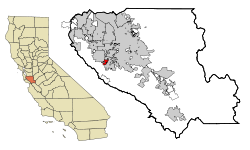
Coordinates: 37°14′17″N 121°59′22″W / 37.23806°N 121.98944°WCoordinates: 37°14′17″N 121°59′22″W / 37.23806°N 121.98944°W Country  United States
State  California
County Santa Clara Incorporated May 14, 1957 Government - Mayor Marshall Anstandig Area[1] - Total 1.615 sq mi (4.184 km2) - Land 1.615 sq mi (4.184 km2) - Water 0 sq mi (0 km2) 0% Elevation[2] 515 ft (157 m) Population (2010) - Total 3,341 - Density 2,068.7/sq mi (798.7/km2) Time zone PST (UTC-8) - Summer (DST) PDT (UTC−7) ZIP code 95030 Area code(s) 408 FIPS code 06-48956 GNIS feature ID 277610 Website http://www.montesereno.org/ Monte Sereno (from Spanish monte, hill, and sereno, serene) is a city in Santa Clara County, California, USA. The population was 3,341 at the 2010 census. The city is located in the foothills of the Santa Cruz Mountains, about 10 miles southwest of San Jose and is immediately northwest of Los Gatos. The city is named for the 2249 ft. El Sereno Mountain, upon whose slopes the southern portion of the city is built on. The community is entirely residential, with no commercial zoning and 99% single-family housing, and is an upscale Silicon Valley bedroom community. Monte Sereno shares the 95030 ZIP code with the Town of Los Gatos. Many municipal services are provided under contract by the city of Los Gatos.
Contents
History
The Monte Sereno area was part of the 1839 Alta California land grant of Rancho Rinconada de Los Gatos. The city incorporated on May 14, 1957 to protect its semi-rural atmosphere.
John Steinbeck wrote The Grapes of Wrath and Of Mice and Men in a wooded home at 16250 Greenwood Lane in what is now Monte Sereno [3]
Beat generation figure Neal Cassady lived in a Monte Sereno ranch house in the 1950s.[4]
Geography
Monte Sereno is located at 37°14′17″N 121°59′22″W / 37.238194°N 121.989475°W.[5]
According to the United States Census Bureau, the city has a total area of 1.6 square miles (4.1 km2), all of it land. Saratoga-Los Gatos Road (State Route 9) runs through the city.
The El Sereno Open Space Preserve is immediately south of the city and covers the top and portions of the flanks of El Sereno mountain.
Demographics
2010
The 2010 United States Census[6] reported that Monte Sereno had a population of 3,341. The population density was 2,068.4 people per square mile (798.6/km²). The racial makeup of Monte Sereno was 2,698 (80.8%) White, 14 (0.4%) African American, 12 (0.4%) Native American, 464 (13.9%) Asian, 0 (0.0%) Pacific Islander, 28 (0.8%) from other races, and 125 (3.7%) from two or more races. Hispanic or Latino of any race were 162 persons (4.8%).
The Census reported that 100% of the population lived in households.
There were 1,211 households, out of which 433 (35.8%) had children under the age of 18 living in them, 917 (75.7%) were opposite-sex married couples living together, 59 (4.9%) had a female householder with no husband present, 26 (2.1%) had a male householder with no wife present. There were 14 (1.2%) unmarried opposite-sex partnerships, and 8 (0.7%) same-sex married couples or partnerships. 178 households (14.7%) were made up of individuals and 87 (7.2%) had someone living alone who was 65 years of age or older. The average household size was 2.76. There were 1,002 families (82.7% of all households); the average family size was 3.05.
The population was spread out with 816 people (24.4%) under the age of 18, 156 people (4.7%) aged 18 to 24, 487 people (14.6%) aged 25 to 44, 1,235 people (37.0%) aged 45 to 64, and 647 people (19.4%) who were 65 years of age or older. The median age was 48.3 years. For every 100 females there were 96.3 males. For every 100 females age 18 and over, there were 94.2 males.
There were 1,287 housing units at an average density of 796.8 per square mile (307.6/km²), of which 1,090 (90.0%) were owner-occupied, and 121 (10.0%) were occupied by renters. The homeowner vacancy rate was 1.3%; the rental vacancy rate was 5.4%. 3,030 people (90.7% of the population) lived in owner-occupied housing units and 311 people (9.3%) lived in rental housing units.
2000
As of the census[7] of 2000, there were 3,483 people, 1,211 households, and 1,024 families residing in the city. The population density was 2,158.7 people per square mile (835.3/km²). There were 1,237 housing units at an average density of 766.7/sq mi (296.7/km²). The racial makeup of the city was 83.61% White, 0.17% African American, 0.06% Native American, 12.29% Asian, 0.03% Pacific Islander, 1.06% from other races, and 2.78% from two or more races. Hispanic or Latino of any race were 3.59% of the population.
There were 1,211 households out of which 39.1% had children under the age of 18 living with them, 78.0% were married couples living together, 4.0% had a female householder with no husband present, and 15.4% were non-families. 12.6% of all households were made up of individuals and 5.9% had someone living alone who was 65 years of age or older. The average household size was 2.88 and the average family size was 3.13.
In the city the population was spread out with 27.8% under the age of 18, 3.7% from 18 to 24, 21.8% from 25 to 44, 32.2% from 45 to 64, and 14.5% who were 65 years of age or older. The median age was 43 years. For every 100 females there were 99.9 males. For every 100 females age 18 and over, there were 96.6 males.
The median income for a household in the city was $154,268, and the median income for a family was $156,706. Males had a median income of $100,000+ versus $41,875 for females. The per capita income for the city was $76,577. About 3.1% of families and 4.2% of the population were below the poverty line, including 3.9% of those under age 18 and 4.8% of those age 65 or over.
Politics
In the state legislature Monte Sereno is located in the 15th Senate District, represented by Republican Sam Blakeslee, and in the 21st Assembly District, represented by Democrat Rich Gordon. Federally, Monte Sereno is located in California's 14th congressional district, which has a Cook PVI of D +18[8] and is represented by Democrat Anna Eshoo.
Schools
Most of Monte Sereno's residents are served by the Los Gatos Union Elementary School and Los Gatos-Saratoga Union High School Districts while a small portion of residents, primarily in the Bicknell Road area, are served by the Campbell Union School and the Campbell Union High School Districts.
Public services
Public services for Monte Sereno are served by those of the town of Los Gatos. These include The Los Gatos-Monte Sereno Police Department, The Los Gatos Parks and Recreation Department, and Los Gatos Youth sports leagues.
Government
Monte Sereno is a General Law City incorporated on May 14, 1957. It operates under the City Council-City Manager form of local government, which combines the political leadership of a five-member elected City Council with the strong professional experience of an appointed local government administrator (City Manager) who is the responsible for the day-to-day administrative operation of the City, including preparation of the budget, delivery of services, hiring of personnel, and implementation of capital projects.
City Council elections are held the first Tuesday of November in even numbered years. The election is nonpartisan and the Councilmembers are elected "at large" to serve the entire community rather than by district. The Councilmembers are elected to four-year terms. In 1998 voters approved an ordinance limiting the number of terms a member of the Monte Sereno City Council may serve on the City Council to two consecutive four year terms with a right to hold office again only after at least two years have elapsed since that person last held office.
In 2004 the City Council voted to cancel the election because only the two incumbents whose terms were up, Erin Garner and David Baxter, filed candidacy papers to run for the two available seats.
In 2008 the City Council voted to hold the election for the two available seats despite there being only two candidates, Lana Malloy and Susan Garner, for those seats.
Year Mayor All Council Members 2011 Marshall Anstandig Marshall Anstandig, Burton Craig, Lana Malloy, Susan Garner, Curtis Rogers 2010 Don Perry Marshall Anstandig, Lana Malloy, Susan Garner, Don Perry, A. Curtis Wright 2009 A. Curtis Wright Marshall Anstandig, Lana Malloy, Susan Garner, Don Perry, A. Curtis Wright 2008 Erin Garner Alan Aerts-->Marshall Anstandig(1), David Baxter, Erin Garner, Don Perry, A. Curtis Wright 2007 David Baxter Alan Aerts, David Baxter, Erin Garner, Don Perry, A. Curtis Wright 2006 Mark Brodsky David Baxter, Mark Brodsky, Erin Garner, Barbara Nesbet, A. Curtis Wright 2005 A. Curtis Wright David Baxter, Mark Brodsky, Erin Garner, Barbara Nesbet, A. Curtis Wright 2004 Erin Garner David Baxter, Mark Brodsky, Erin Garner, Barbara Nesbet, A. Curtis Wright 2003 David Baxter David Baxter, Mark Brodsky, Erin Garner, Barbara Nesbet, A. Curtis Wright 2002 Jack Lucas David Baxter, Erin Garner, Suzanne Jackson, Jack Lucas, Barbara Nesbet 2001 Barbara Nesbet David Baxter, Erin Garner, Suzanne Jackson, Jack Lucas, Barbara Nesbet 2000 Suzanne Jackson Fred Hawkes(2), Suzanne Jackson, Gordon Knight, Lucas, Barbara Nesbet 1999 Jack Lucas Joel Gambord, Suzanne Jackson, Gordon Knight, Lucas, Barbara Nesbet 1998 Suzanne Jackson Dorothea Bamford, Joel Gambord, Gordon Knight, Jack Lucas, Suzanne Jackson 1997 Jack Lucas Dorothea Bamford, Joel Gambord, Gordon Knight, Jack Lucas, Suzanne Jackson 1996 Nancy Hobbs Dorothea Bamford, Nancy Hobbs, Suzanne Jackson, Jack Lucas 1995 Dorothea Bamford, Nancy Hobbs, Suzanne Jackson, Jack Lucas 1994 Dorothea Bamford, Nancy Hobbs, Jack Lucas 1993 Dorothea Bamford, Nancy Hobbs, Jack Lucas 1992 Dorothea Bamford, Jack Lucas, Barbara Winckler 1991 Dorothea Bamford, Jack Lucas, Barbara Winckler 1990 Dorothea Bamford, Jack Lucas, Barbara Winckler 1989 Dorothea Bamford, Jack Lucas, Barbara Winckler 1988 Dorothea Bamford, Jack Lucas, Barbara Winckler 1987 Dorothea Bamford, Jack Lucas, Barbara Winckler 1986 Dorothea Bamford, Jack Lucas, Barbara Winckler 1985 Dorothea Bamford, Jack Lucas, Barbara Winckler 1984 Dorothea Bamford, Jack Lucas, Barbara Winckler 1983 Dorothea Bamford, Barbara Winckler (1) Marshall Anstandig was appointed November 18, 2008 to fill Alan Aerts' seat after Mr. Aerts resigned on October 21, 2008 for health reasons.
(2) Appointed April 13, 2000 to fill Joel Gambord's seat when Mr. Gambord moved out of the City.Notable events
Christmas Decorations - A dispute between two neighbors over extravagant Christmas decorations gained Monte Sereno attention in national news. Bonnie and Alan Aerts of Monte Sereno had for years showcased elaborate holiday displays, costing as much as US$150,000, on their front yard. The displays attracted large masses of visitors, resulting in great traffic around the normally quiet cul-de-sac of four houses. Neighbors Le and Susan Nguyen protested, and, in late 2003, the city council voted 3-2 (Nesbet, Brodsky, Wright for, Garner, Baxter against) to pass an ordinance regarding "regulation of special events" [1], [2] which would require permits for such displays. On the first Christmas season for which the law was effective (in 2004), the Aertses declined to apply for a permit, which would allow the Aerts's holiday display to be active only for 12 hours in a 72-hour period and would require a 30-day waiting period before a new 72-hour permit could be applied for. Instead, they erected a huge, 10-foot-tall Grinch on their lawn, who swayed from side while singing "You're a Mean One, Mr. Grinch". The Grinch's outsretched arm pointed conspicuously at the home of the Nguyens. [3]
The spectacle gained mention from the Associated Press and NPR. [4] The Aerts and the Nguyens also appeared on Jimmy Kimmel Live, a late night talk show, about the situation.
Padgett Lawsuit - - Darla and Joe Padgett and the City of Monte Sereno have been engaged in various lawsuits stemming out of incidents relating to the Padgett's building of a home which was started in 1999. The City began with allegations of code violations and a too-tall wooden fence and later the Padgetts claimed, and later proved, a city employee had written them a threatening letter and that there had been numerous other attempts made to intimidate them. In September 2007, Monte Sereno's city manager, Brian Loventhal, was found to have destroyed evidence and in June 2009 a jury found Mayor Curtis Wright violated the couple's civil rights and awarded the Padgetts $1 in compensatory damages, $200,000 in punitive damages, and awarded more than $4,000,000 in attorney's fees—more than the City's entire annual budget. [5]
References
- ^ U.S. Census
- ^ U.S. Geological Survey Geographic Names Information System: Monte Sereno
- ^ Monte Sereno history
- ^ Clarence Cromwell (1997-08-27). "The Beat Goes Down". Metro Silicon Valley. http://www.metroactive.com/papers/metro/08.28.97/slices-9735.html. Retrieved 2008-05-04.
- ^ "US Gazetteer files: 2010, 2000, and 1990". United States Census Bureau. 2011-02-12. http://www.census.gov/geo/www/gazetteer/gazette.html. Retrieved 2011-04-23.
- ^ All data are derived from the United States Census Bureau reports from the 2010 United States Census, and are accessible on-line here. The data on unmarried partnerships and same-sex married couples are from the Census report DEC_10_SF1_PCT15. All other housing and population data are from Census report DEC_10_DP_DPDP1. Both reports are viewable online or downloadable in a zip file containing a comma-delimited data file. The area data, from which densities are calculated, are available on-line here. Percentage totals may not add to 100% due to rounding. The Census Bureau defines families as a household containing one or more people related to the householder by birth, opposite-sex marriage, or adoption. People living in group quarters are tabulated by the Census Bureau as neither owners nor renters. For further details, see the text files accompanying the data files containing the Census reports mentioned above.
- ^ "American FactFinder". United States Census Bureau. http://factfinder.census.gov. Retrieved 2008-01-31.
- ^ "Will Gerrymandered Districts Stem the Wave of Voter Unrest?". Campaign Legal Center Blog. http://www.clcblog.org/blog_item-85.html. Retrieved 2008-02-10.
External links
- City of Monte Sereno Official Web Site
- Map of El Sereno Open Space Preserve
- Photos from El Sereno Open Space Preserve
Municipalities and communities of Santa Clara County, California County seat: San Jose Cities and towns Campbell | Cupertino | Gilroy | Los Altos | Los Altos Hills | Los Gatos | Milpitas | Monte Sereno | Morgan Hill | Mountain View | Palo Alto | San Jose | Santa Clara | Saratoga | Sunnyvale
CDPs Alum Rock | Burbank | Cambrian Park | East Foothills | Fruitdale | Lexington Hills | Loyola | San Martin | Stanford
Unincorporated
communitiesBell Station | Casa Loma | Chemeketa Park | Coyote | Holy City | Loma Chiquita | Old Gilroy | New Almaden | Redwood Estates | Rucker | San Antonio Valley | Sargent | Sveadal
Ghost towns Categories:- Cities in Santa Clara County, California
- Cities in the San Francisco Bay Area
- Incorporated cities and towns in California


Wikimedia Foundation. 2010.