- Rolling Hills, California
Infobox Settlement
official_name = City of Rolling Hills
other_name =
native_name =
nickname =
motto =
imagesize =
image_caption =
flag_size =
seal_size = 81
image_shield =
shield_size =
image_blank_emblem =
blank_emblem_size =
imagesize =
image_caption =
flag_size =
seal_size = 81
image_shield =
shield_size =
image_blank_emblem =
blank_emblem_size =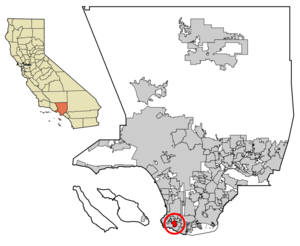
mapsize = 250x200px
map_caption = Location of Rolling Hills in Los Angeles County,California
mapsize1 =
map_caption1 =
subdivision_type = Country
subdivision_name =United States
subdivision_type1 = State
subdivision_name1 =California
subdivision_type2 = County
subdivision_name2 = Los Angeles
subdivision_type3 =
subdivision_name3 =
subdivision_type4 =
subdivision_name4 =
government_type =
leader_title =Mayor
leader_name = B. Allen Lay [cite web | url = http://palosverdes.com/rh/officials.htm | title = City of Rolling Hills City Officials | accessdate = 2007-01-18]
leader_title1 =
leader_name1 =
leader_title2 =
leader_name2 =
leader_title3 =
leader_name3 =
established_title =
established_date =
established_title2 =
established_date2 =
established_title3 = Incorporated (city)
established_date3 =1957-01-24 [cite web | url = http://www.cacities.org/resource_files/20457.IncorpDateLO.doc | title = Incorporation Dates of California Cities | accessdate = 2007-01-18]
area_magnitude =
area_total_km2 = 7.97
area_total_sq_mi = 3.08
area_land_km2 = 7.97
area_land_sq_mi = 3.08
area_water_km2 = 0.00
area_water_sq_mi = 0.00
area_water_percent = 0.00
area_urban_km2 =
area_urban_sq_mi =
area_metro_km2 =
area_metro_sq_mi =
population_as_of = 2000
population_note =
population_footnotes = [cite web | url = http://factfinder.census.gov/servlet/SAFFFacts?_event=ChangeGeoContext&geo_id=16000US0662602&_geoContext=&_street=&_county=&_cityTown=Rolling+Hills+city&_state=04000US06&_zip=&_lang=en&_sse=on&ActiveGeoDiv=&_useEV=&pctxt=fph&pgsl=010&_submenuId=factsheet_1&ds_name=DEC_2000_SAFF&_ci_nbr=null&qr_name=null®=null%3Anull&_keyword=&_industry= | title = Rolling Hills city, California - Fact Sheet - American FactFinder | accessdate = 2007-01-18]
settlement_type =City
population_total = 1,871
population_density_km2 = 234.6
population_density_sq_mi = 607.7
population_metro =
population_density_metro_km2 =
population_density_metro_sq_mi =
population_urban =
population_density_urban_km2 =
population_density_urban_sq_mi =
timezone = PST
utc_offset = -8
timezone_DST = PDT
utc_offset_DST = -7
latd = 33 |latm = 45 |lats = 34 |latNS = N
longd = 118 |longm = 20 |longs = 30 |longEW = W
elevation_m = 389
elevation_ft = 1276
postal_code_type =ZIP code
postal_code = 90274
area_code = 310
website = [http://palosverdes.com/rh/ http://palosverdes.com/rh/]
blank_name = FIPS code
blank_info = 06-62602
blank1_name = GNIS feature ID
blank1_info = 1661325
footnotes =Rolling Hills is a city in Los Angeles County,
California ,United States . As of the2000 census, the city population was 1,871. According to the 2000 US Census, Rolling Hills is the 21st richest place in the United States (based uponper capita income ), and #4 for places with a population of at least 1,000.Rolling Hills consists of a single
gated community . Residents work, shop, attend school, and obtain other services in the other towns on thePalos Verdes Peninsula . Incorporated in1957 , the city maintains a ranch character, with notraffic light s, large spaces between houses (cf. population density below), and wide equestrian paths along streets. The city borders Rolling Hills Estates to the north and Rancho Palos Verdes on all other sides (including the emptyPortuguese Bend landslide area to the south).Geography
Rolling Hills is located at coor dms|33|45|34|N|118|20|30|W|city (33.759350, -118.341550)GR|1.
According to the
United States Census Bureau , the city has a total area of 8.0km² (3.1 mi²), all land.Demographics
As of the
census GR|2 of 2000, there were 1,871 people, 645 households, and 554 families residing in the city. Thepopulation density was 234.5/km² (607.7/mi²). There were 682 housing units at an average density of 85.5/km² (221.5/mi²). The racial makeup of the city was 79.80% White, 2.03% African American, 14.00% Asian, 0.48% Pacific Islander, 1.18% from other races, and 2.51% from two or more races. Hispanic or Latino of any race were 4.54% of the population.There were 645 households out of which 33.8% had children under the age of 18 living with them, 80.6% were married couples living together, 3.4% had a female householder with no husband present, and 14.1% were non-families. 12.4% of all households were made up of individuals and 8.1% had someone living alone who was 65 years of age or older. The average household size was 2.90 and the average family size was 3.11.
In the city the population was spread out with 25.9% under the age of 18, 4.1% from 18 to 24, 15.1% from 25 to 44, 32.8% from 45 to 64, and 22.1% who were 65 years of age or older. The median age was 48 years. For every 100 females there were 96.1 males. For every 100 females age 18 and over, there were 92.5 males.
The median income for a household in the city was in excess of $200,000, as is the median income for a family. Males have a median income in excess of $100,000 versus $52,500 for females. The
per capita income for the city was $111,031. None of the families and 1.3% of the population were below thepoverty line . No one under the age of 18 or 65 and older were living below the poverty line.Education
The city is served by Palos Verdes Peninsula Unified School District. PVPUSD schools have constantly ranked among the best in California and the nation. The Washington Post once ranked Palos Verdes Peninsula High School as the 8th best public or private high school in the nation. Also, Chadwick School is well known K-12 private school that serves the area.
Politics
In the state legislature Rolling Hills is located in the 25th Senate District, represented by Democrat
Edward Vincent , and in the 54th Assembly District, represented by DemocratBetty Karnette . Federally, Rolling Hills is located inCalifornia's 46th congressional district , which has a Cook PVI of R +6 [cite web | title = Will Gerrymandered Districts Stem the Wave of Voter Unrest? | publisher = Campaign Legal Center Blog | url=http://www.clcblog.org/blog_item-85.html | accessdate = 2008-02-10] and is represented by RepublicanDana Rohrabacher .References
External links
* [http://www.palosverdes.com/rh/ Rolling Hills official website]
* [http://www.lacdcs.com/station-end-page-17.html LA County Disaster Communications Service ( DCS ) Lomita Sheriff Station]
Wikimedia Foundation. 2010.