- Hawaiian Gardens, California
Infobox Settlement
official_name = City of Hawaiian Gardens, California
other_name =
native_name =
nickname =
settlement_type =City
motto = "The Little City...With A Lot of Heart", "The City on the Move"
imagesize =
image_caption =
flag_size =
image_
seal_size =
image_shield =
shield_size =
image_blank_emblem =
blank_emblem_size =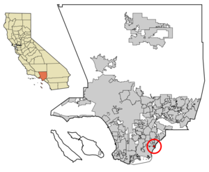
mapsize = 250x200px
map_caption = Location of Hawaiian Gardens in Los Angeles County,California
mapsize1 =
map_caption1 =
image_dot_
dot_mapsize =
dot_map_caption =
dot_x =
dot_y =
pushpin_
pushpin_label_position =
pushpin_map_caption =
pushpin_mapsize =
subdivision_type = Country
subdivision_name =United States
subdivision_type1 = State
subdivision_name1 =California
subdivision_type2 = County
subdivision_name2 = Los Angeles
subdivision_type3 =
subdivision_name3 =
subdivision_type4 =
subdivision_name4 =
government_footnotes =
government_type =
leader_title =Mayor
leader_name = [http://hgcity.org/johnf.php John F. Heckerman]
leader_title1 = Mayor Pro Tem
leader_name1 = [http://hgcity.org/michiko.php Michiko A. Oyama-Canada]
leader_title2 =City Council
leader_name2 = [http://hgcity.org/bettyj.php Betty J. Schultze] [http://hgcity.org/leonard.php Lenoard Chaidez] [http://hgcity.org/petraprida.php Petra Prida]
leader_title3 =
leader_name3 =
leader_title4 =
leader_name4 =
established_title =
established_date =
established_title2 =
established_date2 =
established_title3 =
established_date3 =
area_magnitude =
unit_pref =
area_footnotes =
area_total_km2 = 2.5
area_land_km2 = 2.4
area_water_km2 = 0.1
area_total_sq_mi = 1.0
area_land_sq_mi = 0.96
area_water_sq_mi = 0.04
area_water_percent =
area_urban_km2 =
area_urban_sq_mi =
area_metro_km2 =
area_metro_sq_mi =
area_blank1_title =
area_blank1_km2 =
area_blank1_sq_mi =
population_as_of = 2000
population_footnotes =
population_note =
population_total = 14779
population_density_km2 = 5941.9
population_density_sq_mi = 16421.1
population_metro =
population_density_metro_km2 =
population_density_metro_sq_mi =
population_urban =
population_density_urban_km2 =
population_density_urban_sq_mi =
population_blank1_title =
population_blank1 =
population_density_blank1_km2 =
population_density_blank1_sq_mi =
timezone = PST
utc_offset = -8
timezone_DST = PDT
utc_offset_DST = -7
latd = 33 |latm = 49 |lats = 43 |latNS = N
longd = 118 |longm = 4 |longs = 25 |longEW = W
elevation_footnotes =
elevation_m = 10
elevation_ft = 33
postal_code_type =ZIP code
postal_code = 90716
area_code = 562
blank_name = FIPS code
blank_info = 06-32506
blank1_name = GNIS feature ID
blank1_info = 1652716
website = http://hgcity.org/
footnotes =Hawaiian Gardens is a city in Los Angeles County,
California ,United States . It is the smallest city in the county (approximately 1.0 mi²) and was incorporated onApril 9 ,1964 . The population was 14,779 at the 2000 census. The town's unusual name originated in a 1920s-era refreshment stand that was decorated with palm fronds and bamboo. It was the then-rural area's main landmark for many years, and its name stuck as the small town grew up around it. As one of seven Los Angeles County cities that allow casino gambling, more than $9.2 million (65%) of the city's revenue comes fromHawaiian Gardens Casino , a card club. [cite web |url=http://www.hgcity.org/Budgets/0607BudgetWhole.pdf |title=Budget Summary |accessdate=2006-12-31 |author=City of Hawaiian Gardens |date=13 |year=2006 |month=7 |format= |work= |publisher= |pages= |archiveurl= |archivedate= |quote= ]Geography
Hawaiian Gardens is located at coor dms|33|49|43|N|118|4|25|W|city (33.828565, -118.073646)GR|1. It is bounded by the
Los Angeles County cities of Long Beach and Lakewood, and by the Orange County city of Cypress.According to the
United States Census Bureau , the city has a total area of 2.5km² (1.0 mi²). 2.5 km² (1.0 mi²) of it is land and 0.1 km² (0.04 mi²) of it (2.04%) is water. Hawaiian Gardens is the smallest city in area in Los Angeles County.Demographics
As of the
census GR|2 of 2000, there were 14,779 people, 3,507 households, and 2,868 families residing in the city. Thepopulation density was 5,944.0/km² (15,389.5/mi²). There were 3,624 housing units at an average density of 1,457.5/km² (3,773.7/mi²). The racial makeup of the city was 38.24% White, 4.45% Black or African American, 1.28% Native American, 8.80% Asian, 0.74% Pacific Islander, 41.65% from other races, and 4.85% from two or more races. 73.54% of the population were Hispanic or Latino of any race.There were 3,507 households out of which 52.4% had children under the age of 18 living with them, 53.8% were married couples living together, 19.0% had a female householder with no husband present, and 18.2% were non-families. 14.2% of all households were made up of individuals and 5.8% had someone living alone who was 65 years of age or older. The average household size was 4.21 and the average family size was 4.52.
In the city the population was spread out with 36.8% under the age of 18, 12.6% from 18 to 24, 30.1% from 25 to 44, 14.4% from 45 to 64, and 6.2% who were 65 years of age or older. The median age was 25 years. For every 100 females there were 104.9 males. For every 100 females age 18 and over, there were 102.4 males.
The median income for a household in the city was $34,500, and the median income for a family was $31,840. Males had a median income of $21,074 versus $20,643 for females. The
per capita income for the city was $10,728. About 19.8% of families and 22.1% of the population were below thepoverty line , including 27.4% of those under age 18 and 15.2% of those age 65 or over.Politics
In the state legislature Hawaiian Gardens is located in the 27th Senate District, represented by Democrat
Alan Lowenthal , and in the 56th Assembly District, represented by DemocratTony Mendoza . Federally, Hawaiian Gardens is located inCalifornia's 39th congressional district , which has a Cook PVI of D +13 [cite web | title = Will Gerrymandered Districts Stem the Wave of Voter Unrest? | publisher = Campaign Legal Center Blog | url=http://www.clcblog.org/blog_item-85.html | accessdate = 2008-02-10] and is represented by DemocratLinda Sánchez .Emergency services
Fire protection in Hawaiian Gardens is provided by the
Los Angeles County Fire Department with ambulance transport byCare Ambulance Service . TheLos Angeles County Sheriff's Department provides law enforcement, utilizing the Lakewood Sheriff's Station.In the early 1990s, the City of Hawaiian Gardens, concerned about being serviced from Lakewood, created its own police department, which lasted four years due to increasing pressure from the casino's owner (Irving Moskowitz), who preferred the sheriff's contract over local control.
Education
Hawaiian Gardens is within the
ABC Unified School District .Elementary schools within Hawaiian gardens include:
* [http://www.furges.abcusd.k12.ca.us/ Venn W. Ferguson Elementary School]
* [http://www.hawaes.abcusd.k12.ca.us/ Hawaiian Elementary School]Middle schools within Hawaiian Gardens include:
* [http://www.feddms.abcusd.k12.ca.us/ Pharis F. Fedde Middle School] (Formerly called Killingsworth Junior High School)Residents are zoned to the following high schools:
*Artesia High School in Lakewoodee also
References
External links
* [http://www.hawaiiangardenscity.org/ Hawaiian Gardens city homepage]
* [http://lacdcs.com/station-end-page-13.html LA County Disaster Communications Service ( DCS ) Lakewood Sheriff Station]
* [http://www.hgcasino.com/ Hawaiian Gardens Casino]
* [http://www.capitolweekly.net/news/article.html?article_id=523/ 2006 Capital Weekly article about Dr. Irving Moskowitz]
* [http://www.motherjones.com/news/feature/2000/09/bingo.html/ 2000 Mother Jones article about Dr. Irving Moskowitz]
* [http://www.jewishsf.com/content/2-0-/module/displaystory/story_id/7083/edition_id/133/format/html/displaystory.html/ 1997 article about Dr. Irving Moskowitz from The Jewish News weekly]
* [http://www.jewishsf.com/content/2-0-/module/displaystory/story_id/14088/edition_id/273/format/html/displaystory.html/ 2000 article about Dr. Irving Moskowitz from The Jewish News weekly]
* [http://www.stopmoskowitz.org/ Stop Moskowitz website]

Wikimedia Foundation. 2010.