California State Route 32
- California State Route 32
Infobox road
state=CA
type=SR
route=32
section=332
maint=Caltrans
length_mi=74
length_round=0
length_ref= [ [http://www.dot.ca.gov/hq/structur/strmaint/brlog2.htm January 1, 2006 California Log of Bridges on State Highways] ]
direction_a=West
terminus_a=jct|state=CA|I|5 in Orland
junction=jct|state=CA|SR|45 at Hamilton City
jct|state=CA|SR|99 in Chico
direction_b=East
terminus_b=jct|state=CA|SR|36|SR|89 near Chester
previous_type=SR
previous_route=29
next_type=SR
next_route=33
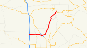
State Route 32 is an east-west state highway in the U.S. State of California which is routed from Interstate 5 in Orland, through Chico, through the northern Sierra Nevada, ending at Routes 36 & 89 in eastern Tehama County.
This route is part of the California Freeway and Expressway System[ [http://www.leginfo.ca.gov/cgi-bin/displaycode?section=shc&group=00001-01000&file=250-257 CA Codes (shc:250-257)] ] .]Other Names
*Nord Avenue (Chico)
*Walnut Street (Chico)
*West Eighth and Ninth Streets (Chico)
*East Eighth and Ninth Streets (Chico)
*Deer Creek Highway (Chico)
*East and West Sixth Street (Hamilton City)
*Walker Street (Orland)
*Newville Road (Orland)
*County Road 200
Major intersections
:"Note: Except where prefixed with a letter, postmiles were measured in 1964, based on the alignment as it existed at that time, and do not necessarily reflect current mileage. The numbers reset at county lines; the start and end postmiles in each county are given in the county column."
External links
* [http://www.dot.ca.gov/hq/roadinfo/sr32 Caltrans: Route 32 highway conditions]
* [http://www.cahighways.org/025-032.html#032 California Highways: SR 32]
References
Wikimedia Foundation.
2010.
Look at other dictionaries:
