- Mount Shasta Wilderness
-
Mount Shasta Wilderness 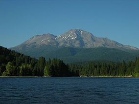
Location Siskiyou County, northern California Nearest city Mount Shasta City Coordinates 41°25′08″N 122°12′26″W / 41.41889°N 122.20722°WCoordinates: 41°25′08″N 122°12′26″W / 41.41889°N 122.20722°W Area 38,200 acres (155 km2) Established 1984 Governing body U.S. Forest Service / USDA The Mount Shasta Wilderness is a 38,200-acre (155 km2) federally designated wilderness area located 5 miles (8.0 km) east of Mount Shasta City in northern California. The US Congress passed the 1984 California Wilderness Act that set aside the Mount Shasta Wilderness. The US Forest Service is the managing agency as the wilderness is within the Shasta-Trinity National Forest. The area is named for and is dominated by the Mount Shasta volcano which reaches a traditionally quoted height of 14,162 feet (4,317 m) above sea level, but official sources give values ranging from 14,104 feet (4,299 m) from one USGS project[1], to 14,179 feet (4,322 m) via the NOAA[2]. Mount Shasta is one of only two peaks in the state over 14,000 feet (4,300 m) outside the Sierra Nevada Mountain Range. The other summit is White Mountain Peak in the Great Basin of east-central California.[3]
The Wintun Glacier is located on Mount Shasta and is the lowest-elevation glacier in the state, lying at 9,100 feet (2,800 m) elevation and extending to the summit.[4]
The smaller volcanic cone of Shastina (12,270 ft)[5] lies one mile (1.6 km) west of Mount Shasta and was formed after the ice-age glaciers melted.
The wilderness protects both pristine forests and areas that were intensively logged and roaded in the past. Although less than half of the mountain remains roadless, Mount Shasta Wilderness is still the premier destination for a variety of activities from mountaineering, day-hiking, and backpacking to cross-country skiing, snowshoeing and ski mountaineering. It is valued for the many scenic, geologic and recreational attributes including glaciers, lava flows, hot springs, waterfalls and forests of Shasta red fir, sugar pine and other conifers.
Contents
Recreation
Being a high, solitary and very large mountain with a base diameter of 17 miles (27 km),[6] Mount Shasta can create it own weather patterns which hikers must be aware of. Also, falling rocks are a major danger above timberline. The best time of year for hiking Mount Shasta is June and July, when routes are still snow-covered. Although there is no designated trail to the summit, many cross-country routes ascend to the mountaintop and all require experience in traversing ice and snow.
There are ten trailheads giving access to the wilderness and several short trails leading up the slopes of Mount Shasta with the so-called Shasta Summit Trail (or Avalanche Gulch) being the most popular. This trail, although the "easiest" of the routes, still requires the use of ice axe and crampons. There are four major glaciers and three smaller glaciers radiating from the summit in addition to lava flows on the northern flank composed of andesite and basalt.
A parking permit is required as well as a free wilderness permit and, if attempting a hike above 10,000 feet (3,000 m), a Summit Pass for each climber must be purchased.[7] Human waste must be packed out, and all principles of Leave No Trace etiquette employed. Some restrictions include no dogs in the wilderness, a limit of 10 people in a group and no wood campfires.[8]
Flora and fauna
Forested areas include pure stands of red fir as well as mixed conifer forests of white fir, Douglas-fir, sugar pine, incense cedar and at higher elevations, western white pine. The lava flows on the northeast flank have mountain mahogany and juniper. Underbrush consists of pinemat manzanita, greenleaf manzanita, tanoak, chinquapin, and snowbrush. From 8,000 feet (2,400 m) to timberline are krummholz forms of whitebark pine.
Wildlife include the ubiquitous black bear, coyote, ground squirrel, deer, Golden eagles, prairie falcons and red-tail hawks.
Common wildflowers are Shasta lily, miner's lettuce, showy phlox and mountain violet among others.
Notable rare plants in the Mount Shasta Wilderness and surrounding area include Mt. Shasta arnica (Arnica viscosa), Siskiyou Indian paintbrush (Castilleja miniata ssp. elata) and Shasta owl's clover (Orthocarpus pachystachyus). The Siskiyou Indian paintbrush is hemiparasitic, meaning that the plant obtains water and nutrients from the roots of other plants, then manufactures food by photosynthesis. The Shasta owl's clover (Orthocarpus pachystachyus) of the Scrophulariaceae family is critically imperiled and was believed to be extinct. First described in 1848 by Harvard University botanist Asa Gray, the plant was not collected again until 1913. Known only from two reports from the Shasta Valley of northern California, it could not be relocated despite repeated searches of the moist meadows and vernal pools where it was thought originally to have been found. In May, 1996, botanist Dean Taylor of the University of California, Berkeley, rediscovered the evasive plant on the higher, drier ground of a sagebrush-covered hillside. But even in this habitat the wildflower appears to be extraordinarily rare. Taylor was able to find only eight individual plants of the owl’s-clover.[9]Sierra Club camp
The Sierra Club maintains a private 720-acre (2.9 km2) parcel called Horse Camp within the wilderness. It is used as a base camp for summit attempts, and offers a shelter called the Shasta Alpine Lodge, dedicated in 1923 and built from surrounding volcanic rock and Shasta red fir wood. Horse Camp is staffed during the climbing season from May to September, has a seasonal spring for water and is a traditional destination of many elementary school trips from Siskiyou County schools.[10] Also at Horse Camp is the half-mile-long Olberman Causeway, a stone walkway built in the 1920s by the first caretaker, Mac Olberman from rocks of the surrounding area.[11]
References and notes
- ^ [1] United States Geological Survey(USGS)Geographical Names Information System(GNIS)]
- ^ "Datasheet for benchmark MX1016". National Geodetic Survey. http://www.ngs.noaa.gov/cgi-bin/ds_mark.prl?PidBox=MX1016. This seems to be the latest and most accurate measurement from the U.S. Geodetic Survey.
- ^ Atkinson, Ron p.224
- ^ Atkinson, Ron p.227
- ^ USGS-GNIS
- ^ Adkinson, Ron p.224
- ^ Shasta-Trinity National Forest Wilderness page.
- ^ Shasta-Trinity National Forest regulation document.
- ^ The Nature Conservancy 1997 Species Report Card p.21
- ^ Sierra Club website.
- ^ Climbingshasta.org
Adkinson, Ron Wild Northern California. The Globe Pequot Press, 2001 ISBN 1-56044-781-8
External links
- Photo Gallery
- US Forest Service, Mount Shasta Wilderness.
- USFS PDF document on access to the wilderness.
Protected areas of California National Park System National Parks National Preserves National Monuments Cabrillo · Devils Postpile · Lava Beds · Muir Woods · Pinnacles · World War II Valor in the Pacific National MonumentNational Seashores National Historical Parks National Historic Sites National Memorials Port Chicago Naval MagazineNational Recreation Areas National Forests National Forests Angeles · Cleveland · Eldorado · Inyo · Klamath · Lassen · Los Padres · Mendocino · Modoc · Plumas · San Bernardino · Sequoia · Shasta-Trinity · Sierra · Six Rivers · Stanislaus · TahoeNational Wilderness
Preservation SystemAgua Tibia · Ansel Adams · Bucks Lake · Caribou · Carson-Iceberg · Castle Crags · Cucamonga · Desolation · Dick Smith · Dinkey Lakes · Emigrant · Golden Trout · Hoover · Inyo Mountains · Ishi · Jennie Lakes · John Muir · Kaiser · Marble Mountain · Mokelumne · Mount Shasta Wilderness · North Fork · San Gabriel · Sanhedrin · San Jacinto · San Rafael · Sespe · Siskiyou · Snow Mountain · South Fork Eel River · South Sierra · South Warner · Thousand Lakes · Trinity Alps · Ventana · Yolla Bolly-Middle Eel · YukiOther State Forests Boggs Mountain Demonstration · Ellen Pickett · Jackson Demonstration · Las Posadas · LaTour Demonstration · Mount Zion · Mountain Home Demonstration · Soquel Demonstration
National Wildlife Refuges Antioch Dunes · Bitter Creek · Blue Ridge · Butte Sink · Castle Rock · Clear Lake · Coachella Valley · Colusa · Delevan · Don Edwards San Francisco Bay · Ellicott Slough · Farallon · Guadalupe-Nipomo Dunes · Hopper Mountain · Humboldt Bay · Kern · Lower Klamath · Marin Islands · Merced · Modoc · Pixley · Sacramento · Sacramento River · Salinas River · San Diego Bay · San Diego · San Joaquin River · San Luis · San Pablo Bay · Seal Beach · Sonny Bono Salton Sea · Stone Lakes · Sutter · Tijuana Slough · Tule LakeState Wildlife Areas Wildlife Areas Antelope Valley · Ash Creek · Bass Hill · Battle Creek · Big Lagoon · Big Sandy · Biscar · Butte Valley · Buttermilk Country · Cache Creek · Camp Cady · Cantara/Ney Springs · Cedar Roughs · Cinder Flats · Collins Eddy · Colusa Bypass · Coon Hollow · Cottonwood Creek · Crescent City Marsh · Crocker Meadows · Daugherty Hill · Decker Island · Doyle · Dutch Flat · Eastlker River · Eel River · Elk Creek Wetlands · Elk River · Fay Slough · Feather River · Fitzhugh Creek · Fremont Weir · Grass Lake · Gray Lodge · Green Creek · Grizzly Island · Hallelujah Junction · Heenan Lake · Hill Slough · Hollenbeck Canyon · Honey Lake · Hope Valley · Horseshoe Ranch · Imperial · Indian Valley · Kelso Peak and Old Dad Mountains · Kinsman Flat · Knoxville · Laguna · Lake Berryessa · Lake Earl · Lake Sonoma · Little Panoche Reservoir · Los Banos · Lower Sherman Island · Mad River Slough · Marble Mountains · Mendota · Merrill's Landing · Miner Slough · Monache Meadows · Morro Bay · Moss Landing · Mouth of Cottonwood Creek · Napa-Sonoma Marshes · North Grasslands · O'Neill Forebay · Oroville · Petaluma Marsh · Pickel Meadow · Pine Creek · Point Edith · Putah Creek · Rector Reservoir · Red Lake · Rhode Island · Sacramento River · San Felipe Valley · San Jacinto · San Luis Obispo · San Luis Reservoir · San Pablo Bay · Santa Rosa · Shasta Valley · Silver Creek · Slinkard/Little Antelope · Smithneck Creek · South Fork · Spenceville · Surprise Valley · Sutter Bypass · Tehama · Truckee River · Upper Butte Basin · Volta · Warner Valley · Waukell Creek · West Hilmar · Westlker River · White Slough · Willow Creek · Yolo BypassEcological Reserves Albany Mudflats · Alkali Sink · Allensworth · Atascadero Creek Marsh · Bair Island · Baldwin Lake · Batiquitos Lagoon · Blue Sky · Boden Canyon · Boggs Lake · Bolsa Chica · Bonny Doon · Buena Vista Lagoon · Butler Slough · Butte Creek Canyon · Butte Creek House · Buttonwillow · By Day Creek · Calhoun Cut · Canebrake · Carlsbad Highlands · Carmel Bay · Carrizo Canyon · Carrizo Plains · China Point · Clover Creek · Coachella Valley · Coal Canyon · Corte Madera Marsh · Crestridge · Dairy Mart Ponds · Dales Lake · Del Mar Landing · Eden Landing · Elkhorn Slough · Estelle Mountain · Fall River Mills · Fish Slough · Fremont Valley · Goleta Slough · Indian Joe Spring · Kaweah · Kerman · King Clone · Laguna Laurel · Loch Lomond Vernal Pool · Lokern · Magnesia Spring · Marin Islands · Mattole River · McGinty Mountain · Morro Dunes · Morro Rock · Napa River · North Table Mountain · Oasis Spring · Panoche Hills · Peytonia Slough · Pine Hill · Piute Creek · Pleasant Valley · Point Lobos · Rancho Jamul · Redwood Shores · River Springs Lakes · Saline Valley · San Dieguito Lagoon · San Elijo Lagoon · San Felipe Creek · San Joaquin River · Santa Rosa Plateau · Springville · Stone Corral · Sycamore Canyon · Sycuan Peak · Thomes Creek · Tomales Bay · Upper Newport Bay · Watsonville Slough · West Mojave Desert · Woodbridge · YaudanchiMarine Protected Areas Abalone Cove · Agua Hedionda Lagoon · Albany Mudflats · Anacapa · Anacapa · Año Nuevo · Asilomar · Atascadero Beach · Bair Island · Batiquitos Lagoon · Big Creek · Big Creek · Big Sycamore Canyon · Bodega · Bolsa Chica · Buena Vista Lagoon · Cambria · Cardiff and San Elijo · Carmel Bay · Carmel Pinnacles · Carrington Point · Catalina Marine Science Center · Corte Madera Marsh · Crystal Cove · Dana Point · Del Mar Landing · Doheny · Doheny · Duxbury Reef · Edward F. Ricketts · Elkhorn Slough · Elkhorn Slough · Encinitas · Estero de Limantour · Fagan Marsh · Farallon Islands · Farnsworth Bank · Fort Ross · Gerstle Cove · Goleta Slough · Greyhound Rock · Gull Island · Harris Point · Heisler Park · Hopkins · Irvine Coast · James V. Fitzgerald · Judith Rock · Julia Pfeiffer Burns · La Jolla · Laguna Beach · Lovers Cove (Catalina Island) · Lovers Point · MacKerricher · Manchester and Arena Rock · Marin Islands · Mia J. Tegner · Moro Cojo Slough · Morro Bay · Morro Bay · Morro Beach · Natural Bridges · Niguel · Pacific Grove Marine Gardens · Painted Cave · Peytonia Slough · Piedras Blancas · Piedras Blancas · Pismo · Pismo-Oceano Beach · Point Buchon · Point Buchon · Point Cabrillo · Point Fermin · Point Lobos · Point Reyes Headlands · Point Sur · Point Sur · Portuguese Ledge · Punta Gorda · Redwood Shores · Refugio · Richardson Rock · Robert E. Badham · Robert W. Crown · Russian Gulch · Russian River · Salt Point · San Diego-Scripps · San Dieguito Lagoon · San Elijo Lagoon · Santa Barbara Island · Scorpion · Skunk Point · Sonoma Coast · Soquel Canyon · South Laguna Beach · South Point · Tomales Bay · Upper Newport Bay · Van Damme · Vandenberg · White Rock (Cambria)National Landscape Conservation System National Monuments National Conservation Areas Wilderness Areas Argus Range · Big Maria Mountains · Bigelow Cholla Garden · Bighorn Mountain · Black Mountain · Bright Star · Bristol Mountains · Cadiz Dunes · Carrizo Gorge · Chemehuevi Mountains · Chimney Peak · Chuckwalla Mountains · Chumash · Cleghorn Lakes · Clipper Mountain · Coso Range · Coyote Mountains · Darwin Falls · Dead Mountains · Dick Smith · El Paso Mountains · Fish Creek Mountains · Funeral Mountains · Golden Valley · Grass Valley · Headwaters Forest Reserve · Hollow Hills · Ibex · Indian Pass · Inyo Mountains · Jacumba · Kelso Dunes · Kiavah · Kingston Range · Little Chuckwalla Mountains · Little Picacho · Machesna Mountain · Matilija · Malpais Mesa · Manly Peak · Mecca Hills · Mesquite · Newberry Mountains · Nopah Range · North Algodones Dunes · North Mesquite Mountains · Old Woman Mountains · Orocopia Mountains · Otay Mountain · Owens Peak · Pahrump Valley · Palen/McCoy · Palo Verde Mountains · Picacho Peak · Piper Mountain · Piute Mountains · Red Buttes · Resting Spring Range · Rice Valley · Riverside Mountains · Rodman Mountains · Sacatar Trail · Saddle Peak Hills · San Gorgonio · Santa Lucia · Santa Rosa · Sawtooth Mountains · Sespe · Sheephole Valley · South Nopah Range · Stateline · Stepladder Mountains · Surprise Canyon · Sylvania Mountains · Trilobite · Turtle Mountains · Whipple Mountains ·National Marine Sanctuaries National Estuarine Research Reserves Elkhorn Slough · San Francisco Bay · Tijuana River Estuary
University of California Natural Reserve System Año Nuevo Island · Bodega Marine · Box Springs · Boyd Deep Canyon Desert Research Center · Burns Piñon Ridge · Carpinteria Salt Marsh · Chickering American River · Coal Oil Point · Dawson Los Monos Canyon · Eagle Lake Field Station · Elliott Chaparral · Emerson Oaks · Fort Ord · Hastings · James San Jacinto Mountains · Jenny Pygmy Forest · Jepson Prairie · Kendall-Frost Mission Bay Marsh · Kenneth S. Norris Rancho Marino · Landels-Hill Big Creek · McLaughlin · Motte Rimrock · Quail Ridge · Sagehen Creek Field Station · San Joaquin Freshwater Marsh · Santa Cruz Island · Scripps Coastal · Sedgwick · Stebbins Cold Canyon · Steele Burnand Anza-Borrego · Stunt Ranch Santa Monica Mountains · Sweeney Granite Mountains Desert Research Center · Valentine Eastern Sierra · Younger LagoonHeritage registers: World Heritage Sites · World Network of Biosphere Reserves · National Register of Historic Places · National Historic Landmarks · National Natural Landmarks · California Historical Landmarks · California Points of Historical Interest · California Register of Historical Resources
Categories:- IUCN Category Ib
- Mount Shasta
- Protected areas of Siskiyou County, California
- Wilderness Areas of California

Wikimedia Foundation. 2010.