- Mokelumne Wilderness
-
Mokelumne Wilderness 
Mokelumne WildernessMap of the United States

Location Sierra Nevada Mountain Range, Alpine / Amador / Calaveras counties, California Nearest city South Lake Tahoe, California (north), Markleeville, California (east) Coordinates 38°35′00″N 119°58′43″W / 38.5833333°N 119.97861°WCoordinates: 38°35′00″N 119°58′43″W / 38.5833333°N 119.97861°W Area 105,165 acres (425.59 km2) Established 1964 Governing body USDA / U.S. Forest Service The Mokelumne Wilderness is a 105,165-acre (425.59 km2)[1] federally designated wilderness area located 70 miles (110 km) east of Sacramento, California. It is within the boundaries of three national forests: Stanislaus, Eldorado and Toiyabe. First protected under the Wilderness Act of 1964, the Mokelumne’s (pronounced moo-ka-la-mi) borders were expanded under the California Wilderness Act of 1984 with the addition of 55,000[2] acres. The wilderness takes its name from the Mokelumne River, which was named after a Mi-wok Indian village located on the riverbank in California's Central Valley.[3]
The wilderness encompasses an area of the Sierra Nevada mountain range between Ebbetts Pass to Carson Pass. There are two sections separated by the Blue Lakes Road and an Off-Road Vehicle corridor.
Elevations range from 4,000 feet (1,200 m) to 10,381 feet (3,164 m). The highest point is Round Top (10,364 feet[4]), a remnant volcano from which the wilderness area's volcanic soils are derived from and is located on the east side of the Sierra crest.
Contents
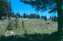
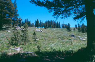
Landscape, flora and fauna
The west slopes have been eroded by glaciation and water down to the granite bedrock which has created a dramatic contrast between the volcanic and the granitic landscapes.
The wilderness protects habitat for a great variety of plants and animals especially on the slopes of Round Top, which is designated a special interest area. Plants include Ponderosa pine, canyon live oak as well as alpine vegetation of Whitebark pine, subalpine fir, and western juniper, with western white pine, mountain hemlock, and lodgepole pine found in sheltered areas. Waterways such as the North Fork of the Mokelumne River have riparian zones of white and mountain alder, creek dogwood, western azalea and bitter cherry. Wildlife include the black bear and mule deer, as well as martin, bald eagle and the California spotted owl.[5]
Areas of special interest
The Round Top Botanical Area is at the junction of three botanical provinces and includes red fir forest, sagebrush scrub, subalpine and alpine environments. The combination of soil types, varying exposure and elevations produce diverse plant life, such as the phantom orchid (Cephalanthera austiniae), a rare plant that gets nutrients from dead material (saprophyte). The plant's common name is due to its color being all or mostly white.
The Round Top Geologic Area has more than 3,000 acres (12 km2) within the wilderness and encompasses a variety of geological areas, including exposed granodiorite, lava flows, dikes, glacial moraines and cirques. The landform known as Elephants Back is a rounded mass of solidified lava. Mineralization produced gold-bearing quartz veins, and relics of past gold mining activities are still present in the area.
Recreation

The Mokelumne Wilderness has a variety of recreational opportunities all year. With landscapes ranging from deep canyons to alpine heights and more than two hundred ice-scoured lakes and tarns, fishing and hiking are popular activities as well as cross country skiing. Access is from roads surrounding the wilderness boundary with Carson Pass being the most used entry point. The Pacific Crest Trail, the Tahoe-Yosemite Trail and the Emigrant Summit Trail all cross through the Mokelumne Wilderness. The Emigrant Summit Trail is a designated National Recreation and Historic Trail that follows the western boundary and then passes through the wilderness from Emigrant Valley to Caples Lake.
Wilderness permits are required year-round for overnight visits.[6]
Footnotes
- ^ Official site -Stanislaus NF, Mokulumne History page
- ^ California Wilderness Act of 1984, P.L. 98-425 Sec.101(16)
- ^ Sierra Nevada Wild webpage on Mokelumne Wilderness accessed 16 October 2008
- ^ United States Geological Survey Feature Detail Report.
- ^ Adkinson p.153
- ^ http://www.fs.fed.us/r5/eldorado/recreation/wild/moke/permit/
References
Eldorado National Forest Interpretive Association website. accessed July 30, 2009
Adkinson, Ron Wild Northern California. The Globe Pequot Press, 2001
External links
- Mokelumne Wilderness page, Stanislaus National Forest website.
- Wilderness.net webpage, Mokelumne Wilderness
- Eldorado National Forest's page on Mokelumne
Protected areas of California National Park System National Parks National Preserves National Monuments Cabrillo · Devils Postpile · Lava Beds · Muir Woods · Pinnacles · World War II Valor in the Pacific National MonumentNational Seashores National Historical Parks National Historic Sites National Memorials Port Chicago Naval MagazineNational Recreation Areas National Forests National Forests Angeles · Cleveland · Eldorado · Inyo · Klamath · Lassen · Los Padres · Mendocino · Modoc · Plumas · San Bernardino · Sequoia · Shasta-Trinity · Sierra · Six Rivers · Stanislaus · TahoeNational Wilderness
Preservation SystemAgua Tibia · Ansel Adams · Bucks Lake · Caribou · Carson-Iceberg · Castle Crags · Cucamonga · Desolation · Dick Smith · Dinkey Lakes · Emigrant · Golden Trout · Hoover · Inyo Mountains · Ishi · Jennie Lakes · John Muir · Kaiser · Marble Mountain · Mokelumne · Mount Shasta Wilderness · North Fork · San Gabriel · Sanhedrin · San Jacinto · San Rafael · Sespe · Siskiyou · Snow Mountain · South Fork Eel River · South Sierra · South Warner · Thousand Lakes · Trinity Alps · Ventana · Yolla Bolly-Middle Eel · YukiOther State Forests Boggs Mountain Demonstration · Ellen Pickett · Jackson Demonstration · Las Posadas · LaTour Demonstration · Mount Zion · Mountain Home Demonstration · Soquel Demonstration
National Wildlife Refuges Antioch Dunes · Bitter Creek · Blue Ridge · Butte Sink · Castle Rock · Clear Lake · Coachella Valley · Colusa · Delevan · Don Edwards San Francisco Bay · Ellicott Slough · Farallon · Guadalupe-Nipomo Dunes · Hopper Mountain · Humboldt Bay · Kern · Lower Klamath · Marin Islands · Merced · Modoc · Pixley · Sacramento · Sacramento River · Salinas River · San Diego Bay · San Diego · San Joaquin River · San Luis · San Pablo Bay · Seal Beach · Sonny Bono Salton Sea · Stone Lakes · Sutter · Tijuana Slough · Tule LakeState Wildlife Areas Wildlife Areas Antelope Valley · Ash Creek · Bass Hill · Battle Creek · Big Lagoon · Big Sandy · Biscar · Butte Valley · Buttermilk Country · Cache Creek · Camp Cady · Cantara/Ney Springs · Cedar Roughs · Cinder Flats · Collins Eddy · Colusa Bypass · Coon Hollow · Cottonwood Creek · Crescent City Marsh · Crocker Meadows · Daugherty Hill · Decker Island · Doyle · Dutch Flat · Eastlker River · Eel River · Elk Creek Wetlands · Elk River · Fay Slough · Feather River · Fitzhugh Creek · Fremont Weir · Grass Lake · Gray Lodge · Green Creek · Grizzly Island · Hallelujah Junction · Heenan Lake · Hill Slough · Hollenbeck Canyon · Honey Lake · Hope Valley · Horseshoe Ranch · Imperial · Indian Valley · Kelso Peak and Old Dad Mountains · Kinsman Flat · Knoxville · Laguna · Lake Berryessa · Lake Earl · Lake Sonoma · Little Panoche Reservoir · Los Banos · Lower Sherman Island · Mad River Slough · Marble Mountains · Mendota · Merrill's Landing · Miner Slough · Monache Meadows · Morro Bay · Moss Landing · Mouth of Cottonwood Creek · Napa-Sonoma Marshes · North Grasslands · O'Neill Forebay · Oroville · Petaluma Marsh · Pickel Meadow · Pine Creek · Point Edith · Putah Creek · Rector Reservoir · Red Lake · Rhode Island · Sacramento River · San Felipe Valley · San Jacinto · San Luis Obispo · San Luis Reservoir · San Pablo Bay · Santa Rosa · Shasta Valley · Silver Creek · Slinkard/Little Antelope · Smithneck Creek · South Fork · Spenceville · Surprise Valley · Sutter Bypass · Tehama · Truckee River · Upper Butte Basin · Volta · Warner Valley · Waukell Creek · West Hilmar · Westlker River · White Slough · Willow Creek · Yolo BypassEcological Reserves Albany Mudflats · Alkali Sink · Allensworth · Atascadero Creek Marsh · Bair Island · Baldwin Lake · Batiquitos Lagoon · Blue Sky · Boden Canyon · Boggs Lake · Bolsa Chica · Bonny Doon · Buena Vista Lagoon · Butler Slough · Butte Creek Canyon · Butte Creek House · Buttonwillow · By Day Creek · Calhoun Cut · Canebrake · Carlsbad Highlands · Carmel Bay · Carrizo Canyon · Carrizo Plains · China Point · Clover Creek · Coachella Valley · Coal Canyon · Corte Madera Marsh · Crestridge · Dairy Mart Ponds · Dales Lake · Del Mar Landing · Eden Landing · Elkhorn Slough · Estelle Mountain · Fall River Mills · Fish Slough · Fremont Valley · Goleta Slough · Indian Joe Spring · Kaweah · Kerman · King Clone · Laguna Laurel · Loch Lomond Vernal Pool · Lokern · Magnesia Spring · Marin Islands · Mattole River · McGinty Mountain · Morro Dunes · Morro Rock · Napa River · North Table Mountain · Oasis Spring · Panoche Hills · Peytonia Slough · Pine Hill · Piute Creek · Pleasant Valley · Point Lobos · Rancho Jamul · Redwood Shores · River Springs Lakes · Saline Valley · San Dieguito Lagoon · San Elijo Lagoon · San Felipe Creek · San Joaquin River · Santa Rosa Plateau · Springville · Stone Corral · Sycamore Canyon · Sycuan Peak · Thomes Creek · Tomales Bay · Upper Newport Bay · Watsonville Slough · West Mojave Desert · Woodbridge · YaudanchiMarine Protected Areas Abalone Cove · Agua Hedionda Lagoon · Albany Mudflats · Anacapa · Anacapa · Año Nuevo · Asilomar · Atascadero Beach · Bair Island · Batiquitos Lagoon · Big Creek · Big Creek · Big Sycamore Canyon · Bodega · Bolsa Chica · Buena Vista Lagoon · Cambria · Cardiff and San Elijo · Carmel Bay · Carmel Pinnacles · Carrington Point · Catalina Marine Science Center · Corte Madera Marsh · Crystal Cove · Dana Point · Del Mar Landing · Doheny · Doheny · Duxbury Reef · Edward F. Ricketts · Elkhorn Slough · Elkhorn Slough · Encinitas · Estero de Limantour · Fagan Marsh · Farallon Islands · Farnsworth Bank · Fort Ross · Gerstle Cove · Goleta Slough · Greyhound Rock · Gull Island · Harris Point · Heisler Park · Hopkins · Irvine Coast · James V. Fitzgerald · Judith Rock · Julia Pfeiffer Burns · La Jolla · Laguna Beach · Lovers Cove (Catalina Island) · Lovers Point · MacKerricher · Manchester and Arena Rock · Marin Islands · Mia J. Tegner · Moro Cojo Slough · Morro Bay · Morro Bay · Morro Beach · Natural Bridges · Niguel · Pacific Grove Marine Gardens · Painted Cave · Peytonia Slough · Piedras Blancas · Piedras Blancas · Pismo · Pismo-Oceano Beach · Point Buchon · Point Buchon · Point Cabrillo · Point Fermin · Point Lobos · Point Reyes Headlands · Point Sur · Point Sur · Portuguese Ledge · Punta Gorda · Redwood Shores · Refugio · Richardson Rock · Robert E. Badham · Robert W. Crown · Russian Gulch · Russian River · Salt Point · San Diego-Scripps · San Dieguito Lagoon · San Elijo Lagoon · Santa Barbara Island · Scorpion · Skunk Point · Sonoma Coast · Soquel Canyon · South Laguna Beach · South Point · Tomales Bay · Upper Newport Bay · Van Damme · Vandenberg · White Rock (Cambria)National Landscape Conservation System National Monuments National Conservation Areas Wilderness Areas Argus Range · Big Maria Mountains · Bigelow Cholla Garden · Bighorn Mountain · Black Mountain · Bright Star · Bristol Mountains · Cadiz Dunes · Carrizo Gorge · Chemehuevi Mountains · Chimney Peak · Chuckwalla Mountains · Chumash · Cleghorn Lakes · Clipper Mountain · Coso Range · Coyote Mountains · Darwin Falls · Dead Mountains · Dick Smith · El Paso Mountains · Fish Creek Mountains · Funeral Mountains · Golden Valley · Grass Valley · Headwaters Forest Reserve · Hollow Hills · Ibex · Indian Pass · Inyo Mountains · Jacumba · Kelso Dunes · Kiavah · Kingston Range · Little Chuckwalla Mountains · Little Picacho · Machesna Mountain · Matilija · Malpais Mesa · Manly Peak · Mecca Hills · Mesquite · Newberry Mountains · Nopah Range · North Algodones Dunes · North Mesquite Mountains · Old Woman Mountains · Orocopia Mountains · Otay Mountain · Owens Peak · Pahrump Valley · Palen/McCoy · Palo Verde Mountains · Picacho Peak · Piper Mountain · Piute Mountains · Red Buttes · Resting Spring Range · Rice Valley · Riverside Mountains · Rodman Mountains · Sacatar Trail · Saddle Peak Hills · San Gorgonio · Santa Lucia · Santa Rosa · Sawtooth Mountains · Sespe · Sheephole Valley · South Nopah Range · Stateline · Stepladder Mountains · Surprise Canyon · Sylvania Mountains · Trilobite · Turtle Mountains · Whipple Mountains ·National Marine Sanctuaries National Estuarine Research Reserves Elkhorn Slough · San Francisco Bay · Tijuana River Estuary
University of California Natural Reserve System Año Nuevo Island · Bodega Marine · Box Springs · Boyd Deep Canyon Desert Research Center · Burns Piñon Ridge · Carpinteria Salt Marsh · Chickering American River · Coal Oil Point · Dawson Los Monos Canyon · Eagle Lake Field Station · Elliott Chaparral · Emerson Oaks · Fort Ord · Hastings · James San Jacinto Mountains · Jenny Pygmy Forest · Jepson Prairie · Kendall-Frost Mission Bay Marsh · Kenneth S. Norris Rancho Marino · Landels-Hill Big Creek · McLaughlin · Motte Rimrock · Quail Ridge · Sagehen Creek Field Station · San Joaquin Freshwater Marsh · Santa Cruz Island · Scripps Coastal · Sedgwick · Stebbins Cold Canyon · Steele Burnand Anza-Borrego · Stunt Ranch Santa Monica Mountains · Sweeney Granite Mountains Desert Research Center · Valentine Eastern Sierra · Younger LagoonHeritage registers: World Heritage Sites · World Network of Biosphere Reserves · National Register of Historic Places · National Historic Landmarks · National Natural Landmarks · California Historical Landmarks · California Points of Historical Interest · California Register of Historical Resources
Categories:- IUCN Category Ib
- Protected areas of the Sierra Nevada (U.S.)
- Protected areas of Alpine County, California
- Protected areas of Amador County, California
- Protected areas of Calaveras County, California
- Wilderness Areas of California
- Humboldt-Toiyabe National Forest

Wikimedia Foundation. 2010.