- Lassen County, California
-
Lassen County — County — 
SealLocation in the state of California California's location in the United States
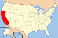
Country  United States
State  California
Region Northeast California Incorporated 1864 County seat Susanville Area – Total 4,720.37 sq mi (12,225.7 km2) – Land 4,557.27 sq mi (11,803.3 km2) – Water 163.10 sq mi (422.4 km2) Population (2010) – Total 34,895 – Density 7.6/sq mi (2.9/km2) Time zone Pacific Standard Time (UTC-8) – Summer (DST) Pacific Daylight Time (UTC-7) Website www.co.lassen.ca.us Lassen County is a county located in the northeastern portion of the U.S. state of California. As of the 2010 census, the population was 34,895, up from 33,828 at the 2000 census. The county seat is Susanville, the only incorporated city in the county.
Contents
History
Lassen County was formed on April 1, 1864 from parts of Plumas and Shasta Counties following the two-day conflict known as the "Sagebrush War", also called the Roop County War,[1] that started on February 15, 1863. Due to uncertainties over the California border, the area that is now Lassen County was part of the unofficial Nataqua Territory and Roop County, Nevada during the late 1850s and early 1860s.
The county was named after Peter Lassen,[2] along with Lassen Peak, which is in adjoining Shasta County. Lassen was one of General John C. Fremont's guides, and a famous trapper, frontiersman and Indian fighter. He was murdered under mysterious circumstances near the Black Rock Desert in 1859, and his murder was never solved.
By the 1880s small towns began to spring up all over Lassen County. Bieber was at the north end of the county, in rich farm land. Hayden Hill was where a gold discovery happened, and a small town sprang up to support the miners. Hayden Hill no longer exists: as the mining stopped, the town's people left for other communities. Madeline was formed at the north end of another rich farming valley, and along the railroad tracks heading north to Alturas, California, this community to this day has about 50 people living in and around the town. A narrow gauge railroad ran through Lassen County from 1880 to 1927, and was called the Nevada-California-Oregon Railway. The N.C.O.R. was the longest small gauge of the century. It was meant to connect Reno, Nevada to the Columbia River, but only 238 miles (383 km) of track were laid, from Reno to Lakeview, Oregon.
In 1913 the Fernley & Lassen Railroad was built and would tap the large timber supplies of Lassen County. Along with this railroad being built, along came the Red River Lumber Company,[3] who built the town of Westwood, California to support their massive logging operation. Two other lumber mills followed the Red River Lumber Co. They built their mills in Susanville, California. The Lassen Lumber & Box Company and the Fruit Growers Company both operated mills in Susanville for several decades.
In May 2007, Sierra Pacific Industries, based in Redding, California, closed the last lumber mill in Susanville, due to the lack of large timber for the mill. The mill was a large-timber mill, and would have required several million dollars to convert it to small timber. Sierra Pacific was reluctant to invest in the mill, and elected to close it permanently.[4]
Geography
According to the 2000 census, the county has a total area of 4,720.37 square miles (12,225.7 km2), of which 4,557.27 square miles (11,803.3 km2) (or 96.54%) is land and 163.10 square miles (422.4 km2) (or 3.46%) is water.[5] Part of Lassen Volcanic National Park extends onto a western corner of the county.
Cities and towns
- Bieber
- Clear Creek Junction
- Doyle
- Herlong
- Janesville
- Johnstonville
- Litchfield
- Madeline
- Milford
- Nubieber
- Ravendale
- Standish
- Spaulding
- Susanville
- Termo
- Wendel
- Westwood
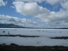 Hog Flat Reservoir covered in snow during Early April
Adjacent counties
- Sierra County, California - southeast
- Plumas County, California - south
- Shasta County, California - west
- Modoc County, California - north
- Washoe County, Nevada - east
National protected areas
- Lassen National Forest (part)
- Lassen Volcanic National Park (part)
- Modoc National Forest (part)
- Plumas National Forest (part)
- Toiyabe National Forest (part)
Transportation Infrastructure
Major highways
 U.S. Route 395
 State Route 36
 State Route 44
 State Route 139
 State Route 299
Public Transportation
Lassen Rural Bus (LRB) runs a local service in Susanville, and longer distance routes to Westwood and Doyle.
Airports
Susanville Municipal Airport, Herlong Airport and Westwood Airport are all general aviation airports.
Politics
Lassen County vote
by party in presidential electionsYear GOP DEM Others 2008 65.8% 7,483 31.5% 3,586 3.2% 364 2004 71.0% 8,126 27.6% 3,158 1.5% 166 2000 66.9% 7,080 28.2% 2,982 5.0% 524 1996 52.6% 5,194 33.6% 3,318 13.8% 1,363 1992 37.2% 3,836 32.7% 3,388 30.3% 3,004 1988 58.6% 5,157 39.2% 3,446 2.3% 199 1984 61.1% 5,352 37.1% 3,254 1.8% 155 1980 54.5% 4,464 35.9% 2,941 9.7% 793 1976 43.0% 3,007 54.3% 3,801 2.7% 190 1972 50.8% 3,618 44.0% 3,134 5.2% 370 1968 41.1% 2,553 47.1% 2,930 11.8% 735 1964 34.3% 2,124 65.7% 4,072 0.1% 5 1960 40.2% 2,365 59.1% 3,472 0.7% 40 1956 42.5% 2,533 57.2% 3,412 0.3% 18 1952 43.7% 3,313 55.8% 4,237 0.5% 39 1948 34.0% 1,960 62.9% 3,632 3.1% 181 1944 33.9% 1,896 65.8% 3,678 0.3% 15 1940 30.1% 1,902 69.2% 4,367 0.7% 44 1936 19.6% 1,035 79.5% 4,193 0.9% 48 1932 26.9% 1,167 70.4% 3,056 2.7% 117 1928 56.7% 2,111 42.9% 1,597 0.4% 13 1924 40.8% 1,072 13.5% 356 45.7% 1,201 1920 66.2% 1,582 26.9% 643 6.9% 164 Lassen is a strongly Republican county in Presidential and congressional elections. The last Democrat to win a majority in the county was Jimmy Carter in 1976.
Lassen is part of California's California's 4th congressional district, which is held by Republican Tom McClintock. In the state legislature, Lassen is part of the 3rd Assembly district, which is held by Republican Dan Logue, and the 1st Senate district, which is held by Republican Ted Gaines.
On Nov. 4, 2008 Lassen County voted 71.3 % for Proposition 8 which amended the California Constitution to ban same-sex marriages.
Demographics
Historical populations Census Pop. %± 1870 1,327 — 1880 3,340 151.7% 1890 4,239 26.9% 1900 4,511 6.4% 1910 4,802 6.5% 1920 8,507 77.2% 1930 12,589 48.0% 1940 14,479 15.0% 1950 18,474 27.6% 1960 13,597 −26.4% 1970 14,960 10.0% 1980 21,661 44.8% 1990 27,598 27.4% 2000 33,828 22.6% 2010 34,895 3.2% [6][7][8] 2010
The 2010 United States Census reported that Lassen County had a population of 34,895. The racial makeup of Lassen County was 25,532 (73.2%) White, 2,834 (8.1%) African American, 1,234 (3.5%) Native American, 356 (1.0%) Asian, 165 (0.5%) Pacific Islander, 3,562 (10.2%) from other races, and 1,212 (3.5%) from two or more races. Hispanic or Latino of any race were 6,117 persons (17.5%).[9]
Population reported at 2010 United States Census The County Total
PopulationWhite African
AmericanNative
AmericanAsian Pacific
Islanderother
racestwo or
more racesHispanic
or Latino
(of any race)Lassen County 34,895 25,532 2,834 1,234 356 165 3,562 1,212 6,117 Incorporated
cityTotal
PopulationWhite African
AmericanNative
AmericanAsian Pacific
Islanderother
racestwo or
more racesHispanic
or Latino
(of any race)Susanville 17,947 11,269 2,249 612 198 111 2,928 580 4,259 Census-designated
placeTotal
PopulationWhite African
AmericanNative
AmericanAsian Pacific
Islanderother
racestwo or
more racesHispanic
or Latino
(of any race)Bieber 312 264 0 15 1 0 24 8 72 Clear Creek 169 149 0 5 0 2 1 12 15 Doyle 678 583 14 37 3 2 12 27 55 Herlong 298 187 38 16 1 3 9 44 46 Janesville 1,408 1,283 13 32 11 3 27 39 118 Johnstonville 1,024 929 7 16 13 0 26 33 73 Litchfield 195 176 0 0 0 0 14 5 25 Milford 167 150 1 1 1 1 4 9 11 Nubieber 50 26 0 13 0 0 6 5 10 Patton Village 702 552 48 27 4 5 18 48 62 Spaulding 178 168 0 3 1 0 1 5 6 Westwood 1,647 1,430 3 104 10 2 49 49 179 Unincorporated
communitiesTotal
PopulationWhite African
AmericanNative
AmericanAsian Pacific
Islanderother
racestwo or
more racesHispanic
or Latino
(of any race)All others not CDPs (combined) 10,120 8,366 461 353 113 36 443 348 1,186 2000
As of the census[10] of 2000, there were 33,828 people, 9,625 households, and 6,776 families residing in the county. The population density was 7 people per square mile (3/km²). There were 12,000 housing units at an average density of 3 per square mile (1/km²). The racial makeup of the county was 80.81% White, 8.84% Black or African American, 3.26% Native American, 0.74% Asian, 0.43% Pacific Islander, 3.23% from other races, and 2.69% from two or more races. 13.84% of the population were Hispanic or Latino of any race. 13.8% were of German, 12.1% Irish, 10.5% English, 8.7% American and 5.0% Italian ancestry according to Census 2000. 88.2% spoke English and 10.3% Spanish as their first language.
There were 9,625 households out of which 35.9% had children under the age of 18 living with them, 55.8% were married couples living together, 10.3% had a female householder with no husband present, and 29.6% were non-families. 24.5% of all households were made up of individuals and 9.2% had someone living alone who was 65 years of age or older. The average household size was 2.59 and the average family size was 3.08.
In the county the population was spread out with 21.8% under the age of 18, 10.8% from 18 to 24, 36.9% from 25 to 44, 21.4% from 45 to 64, and 9.0% who were 65 years of age or older. The median age was 35 years. For every 100 females there were 168.8 males. For every 100 females age 18 and over, there were 192.2 males.
The median income for a household in the county was $36,310, and the median income for a family was $43,398. Males had a median income of $37,333 versus $26,561 for females. The per capita income for the county was $14,749. About 11.1% of families and 14.0% of the population were below the poverty line, including 16.1% of those under age 18 and 7.8% of those age 65 or over.
See also
- Hiking trails in Lassen County
- National Register of Historic Places listings in Lassen County, California
References
- ^ The Roop County War
- ^ Lassen’s Past
- ^ Lassen’s Past
- ^ SPI Closes Lumber Mill
- ^ "Census 2000 U.S. Gazetteer Files: Counties". United States Census. http://www.census.gov/tiger/tms/gazetteer/county2k.txt. Retrieved 2011-02-13.
- ^ http://www.census.gov/population/www/censusdata/cencounts/files/ca190090.txt
- ^ http://factfinder2.census.gov
- ^ http://mapserver.lib.virginia.edu/
- ^ "2010 Census P.L. 94-171 Summary File Data". United States Census Bureau. http://www2.census.gov/census_2010/01-Redistricting_File--PL_94-171/California/.
- ^ "American FactFinder". United States Census Bureau. http://factfinder.census.gov. Retrieved 2008-01-31.
External links

Modoc County Shasta County 
Washoe County, Nevada  Lassen County, California

Plumas County Sierra County Municipalities and communities of Lassen County, California City 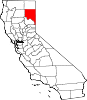
CDPs Bieber | Clear Creek | Doyle | Herlong | Janesville | Johnstonville | Litchfield | Milford | Nubieber | Patton Village | Spaulding | Westwood
Unincorporated
communitiesAvila Place | Belfast | Big Valley | Brockman | Buntingville | Calneva | Coppervale | Crest | Dan Ryan Place | Dixie | Evans Place | Hallelujah Junction | Halls Flat | Hayden Hill | Herlong Junction | Horse Lake | Hot Springs | Jellico | Karlo | Lasco | Leavitt | Leonard | Little Valley | Madeline | Moran | Norvell | Omira | Pine Town | Pinnio | Plumas | Pumpkin Center | Ravendale | Reno Junction | Robbers Creek | Sage Hen | Scotts | Scotty Place | Sheepshead | Shumway | Stacy | Standish | Stones Landing | Termo | The Crossing | Viewland | Wendel | Westwood Junction
Indian reservation Susanville Indian Rancheria
Ghost towns Addington | Antelope | Argusville | Ashton | Atola | Bunnel | Camero | Chats | Clinton | Conman | Constantia | Cromwell | Cuba | Datura | Dayton | Dewitt | Edgemont | Evan's Ranch | Fredonia | Gest | Glade | Goumaz | Hillside | Hausen | Junction House | Juniper | Lake Greeno | Lake Nokopen | Long Valley | Madeline | Mapes | Molitor | Moll Ranch | Murray | Plumas Junction | Prockmans | Purser | Rayl | Red Camp | Roscoe | Sellicks Springs | Secret Springs | Sheep Springs | Soldier's Bridge | Tiptons Springs | Waverly | Wheaton
Categories:- California counties
- Lassen County, California


Wikimedia Foundation. 2010.