- Black Rock Desert
Geobox|Desert
name = Black Rock Desert
native_name =
other_name =
category =
image_caption =
official_name =
etymology =
motto =
nickname =
symbol =
country = United States
state = Nevada
region =
district1 = Humboldt County
district2 = Pershing County
district3 = Washoe County =
municipality =
parent = Great Basin
range =
border =
part =
tributary_left =
tributary_right =
child_left =
child_right =
city =
landmark =
building =
river =
location = lakebed/playa
elevation_imperial = 3848
prominence =
lat_d = 40 | lat_m = 54 | lat_s = 37 | lat_NS = N
long_d = 119 | long_m = 03 | long_s = 18 | long_EW = W
capital =
capital_location = | capital_region = | capital_country =
capital_elevation_imperial =
capital_lat_d = | capital_lat_m = | capital_lat_s = | capital_lat_NS =
capital_long_d = | capital_long_m = | capital_long_s = | capital_long_EW =| highest =
highest_location = | highest_region = | highest_state =
highest_elevation_imperial =
highest_lat_d = | highest_lat_m = | highest_lat_s = | highest_lat_NS =
highest_long_d = | highest_long_m = | highest_long_s = | highest_long_EW =
lowest =
lowest_location = | lowest_region = | lowest_country =
lowest_elevation_imperial =
lowest_lat_d = | lowest_lat_m = | lowest_lat_s = | lowest_lat_NS =
lowest_long_d = | lowest_long_m = | lowest_long_s = | lowest_long_EW =
source =
source_location = | source_region = | source_country =
source_elevation_imperial =
source_lat_d = | source_lat_m = | source_lat_s = | source_lat_NS =
source_long_d = | source_long_m = | source_long_s = | source_long_EW =
source1 =
source1_location = | source1_region = | source1_country =
source1_elevation_imperial =
source1_lat_d = | source1_lat_m = | source1_lat_s = | source1_lat_NS =
source1_long_d = | source1_long_m = | source1_long_s = | source1_long_EW =
source_confluence =
source_confluence_location = | source_confluence_region = | source_confluence_state =
source_confluence_elevation_imperial =
source_confluence_lat_d = | source_confluence_lat_m = | source_confluence_lat_s = | source_confluence_lat_NS =
source_confluence_long_d = | source_confluence_long_m = | source_confluence_long_s = | source_confluence_long_EW =
mouth =
mouth_location = | mouth_region = | mouth_country =
mouth_elevation_imperial =
mouth_lat_d = | mouth_lat_m = | mouth_lat_s = | mouth_lat_NS =
mouth_long_d = | mouth_long_m = | mouth_long_s = | mouth_long_EW =
watershed_imperial = 11600
length_imperial = | length_orientation =
width_imperial = | width_orientation =
height_imperial =
depth_imperial =
volume_imperial =
weight_imperial =
area_imperial = 1000
area_land_imperial =
area_water_imperial =
area_urban_imperial =
area_metro_imperial =
discharge_imperial =
discharge_max_imperial =
discharge_min_imperial =
population = | population_date =
population_urban =
population_metro =
population_density_imperial =
population_density_urban_imperial =
population_density_metro_imperial =
geology =
orogeny =
period =
biome =
plant =
animal =
author =
style =
material =
established =
date =
management = Bureau of Land Management
management_location = | management_region = | management_country =
management_elevation_imperial =
management_lat_d = | management_lat_m = | management_lat_s = | management_lat_NS =
management_long_d = | management_long_m = | management_long_s = | management_long_EW =
government =
government_location = | government_region = | government_country =
government_elevation_imperial =
government_lat_d = | government_lat_m = | government_lat_s = | government_lat_NS =
government_long_d = | government_long_m = | government_long_s = | government_long_EW =
owner =
mayor =
leader =
public = Federal lands (including the playa) are open to the public with regulatory restrictions. Some private lands are in the region and are closed to the public.
visitation = | visitation_date =
access = State Route 447
ascent = | ascent_date =
discovery = | discovery_date =
timezone = Pacific | utc_offset = -8
timezone_DST = PDT | utc_offset_DST = -7
postal_code =
area_code =
code =
whs_name =
whs_year =
whs_number =
whs_region =
whs_criteria =
iucn_category =
free = | free_type =

map_caption = location of Black Rock Desert inNevada
map_background =
map_locator = Nevada
commons =
statistics =
website =
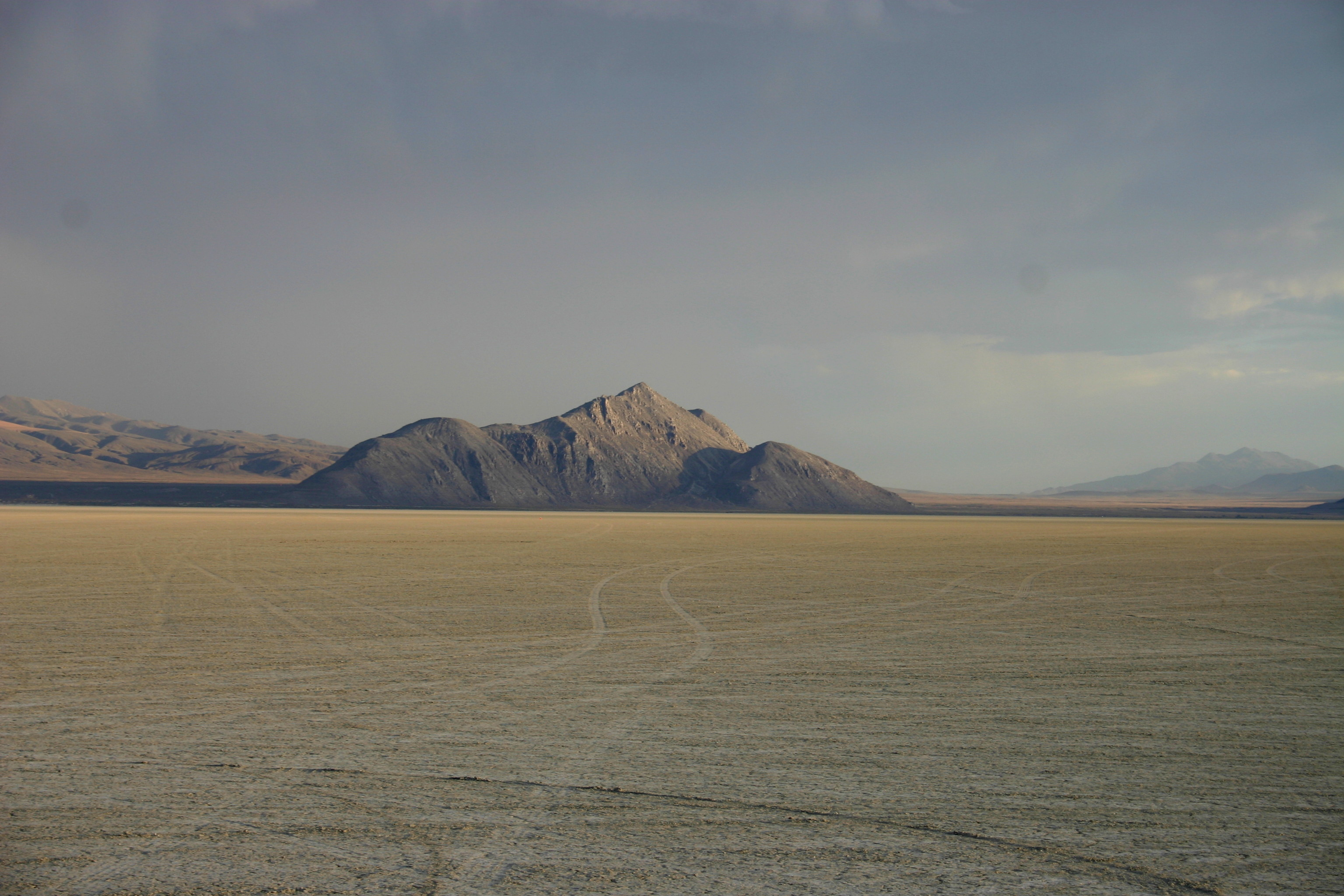
footnotes =The Black Rock Desert is adry lake bed and the surroundingendorheic basin in northwesternNevada in theUnited States . The flat expanse of dry lake, orplaya , is a remnant of theprehistoric Lake Lahontan , which existed between 18,000 and 7,000 BC during the last ice age. During the lake's peak around 12,700 years ago, the desert floor was under approximately 500 feet (150m) of water.The area was used in the mid-1800's by branches of the
California Trail andOregon Trail for settlement of the US West Coast. Since then, the area has been host to scattered mining activity. The Black Rock Desert also hosts various recreational, scientific and record-breaking activities. Most of the area is federal land administered by theBureau of Land Management (BLM), including theBlack Rock Desert-High Rock Canyon Emigrant Trails National Conservation Area and 10 federally-designated wilderness area which protect the areas that had been part of the historic trails. BLM also manages recreational activities in the area.Geography
The Black Rock Desert region is in northwestern
Nevada and the northwesternGreat Basin . The playa extends for approximately 100 miles (160km) northeast from the towns of Gerlach and Empire, between theJackson Mountains to the east and the Calico Mountains to the west. The Black Rock Desert is separated into two arms by theBlack Rock Range . It lies at an elevation of 3848 feet (1172 m) [http://www.highonadventure.com/Hoa06aug/Larry/Black%20Rock%20Desert.htm Black Rock Desert] Larry Turner] and has an area of about 1,000 square miles (2,600 km²).cite book| first=John W. (ed.)| last=Wright| coauthors=Editors and reporters of "The New York Times"| year=2006| title=The New York Times Almanac| edition=2007| publisher=Penguin Books| location=New York, New York| id=ISBN 0-14-303820-6| pages=456]There are several possible definitions of the extent of the Black Rock Desert. Often people refer just to the playa surface. Sometimes terrain which can be seen from the playa is included. The widest definition of the Black Rock Desert region is the watershed of the basin that drains into the playa. The intermittent
Quinn River is the largest river in the region, starting in theSanta Rosa Range and ending in the Quinn River Sink on the playa south of the Black Rock Range. The watershed covers 11,600 square miles [Citation
title = Boundary Descriptions and Names of Regions, Subregions, Accounting Units and Cataloging Units
publisher =United States Geological Survey
date =April 2 ,2007
year = 2007
url = http://water.usgs.gov/GIS/huc_name.html
accessdate = 2008-01-11 ] including the Upper and LowerQuinn River ,Smoke Creek Desert , Massacre Lake, and Thousand Creek [cite web | url=Gnis3|847513 | title=Thousand Creek | work=Geographic Names Information System | publisher=United States Geological Survey | accessdate=2008-01-13 ] /Virgin Valley [cite web | url=Gnis3|847531 | title=Virgin Valley | work=Geographic Names Information System | publisher=United States Geological Survey | accessdate=2008-01-13 ] watersheds of northwestern Nevada as well as small parts across the borders of California and Oregon.Humboldt, Pershing and Washoe Counties of Nevada intersect at the Black Rock Desert.
History
In the mid-1800s, particularly during the
California Gold Rush , the "Applegate-Lassen Cut-Off" of theCalifornia Trail left the main route of that Trail near present-dayRye Patch Reservoir , and crossed the Black Rock Desert, on the way toGoose Lake in northeast California, and the California gold fields. The explorers who mapped the routes through the area and the emigrants who followed them named the Black Rock Desert for a prominent point near a spring along the route now known as Black Rock Point. It is still often called simply "the Black Rock".The flatness of the surface has led to its use as a proving ground for experimental land vehicles. It was the site of the most recent successful attempts on the World
Land Speed Record . In 1983,Richard Noble drove the jet-poweredThrust2 car to a new record of 633 miles per hour. Noble also headed up the team that beat the Thrust 2 record. In 1997,ThrustSSC became the world's first and only supersonic car, reaching 763+ mph. [Land speed record ]In addition to the flat surface, the uncontrolled airspace over the area also attracts experimentation with rockets. The following are highlights of amateur rocketry records [Citation
last = Lindsey
first = Clark
title = HobbySpace.com - Advanced Rocketry: Records, Achievements & Competitions
url = http://www.hobbyspace.com/Rocketry/Advanced/records.html
accessdate = 2008-01-06 ] set at Black Rock:
* OnNovember 23 ,1996 , theReaction Research Society launched a rocket to 50 miles in altitude, a significant leap in amateur rocket altitude records at the time.
* OnMay 17 ,2004 theCivilian Space eXploration Team launched a rocket to 72 miles in altitude, which was the first amateur rocket to exceed the 62-mileKarman Line required to claim a space flight.Use
Prospecting and mining has occurred in the area since the 1800's. The "Sulphur mining district" on the east side of the desert has been the location of
sulfur , mercury,alunite ,silver andgold mining including a currently-active goldstrip mining operation. [cite web
author =Mine Development Associates
title =Technical Report, Vista Gold Corp, Hycroft Mine
month =January | year =2006
url =http://www.vistagoldcorp.com/technical_reports/Hycroft%20Mine,%20Nevada,%20January%202006.pdf
format =PDF
accessdate =2007-03-25 ] Anopal mine is in the base of the Calico Mountains on the west side of the desert. [cite web
title =Little Joe opal mine (Black Rock mine; Little Jo mine), Donnelly District, Humboldt Co., Nevada, USA
work =mindat.org
url =http://www.mindat.org/loc-63583.html
accessdate =2007-03-26 ]The area is also used by several prefectures (regional chapters) of the
Tripoli Rocketry Association . The [http://www.aeropac.org/ Association of Experimental Rocketry of the Pacific (AeroPAC)] hosts "MudRock" in June, "Aeronaut" in late July/early August, and "eXtreme Performance Rocket Ships (XPRS)" in September. [cite web
author =Association of Experimental Rocketry of the Pacific
title =AeroPAC Schedule
month =January | year =2007
url =http://www.aeropac.org/schedule.html
format =HTML
accessdate =2007-07-08 ] The [http://www.ahpra.org/ Arizona High Power Rocketry Association (AHPRA)] hosts " [http://www.ahpra.org/b2k.html BALLS] " in September. It is a significant launch site for high power and amateur rocket hobbyists. When any of these organizations refer to maximum altitudes for their "waivers", they are talking about approval to use the airspace which they have obtained from theFAA .The allowed ceiling in these FAA waivers is commonly up to 100,000 feet, and can be expected to grow higher following the capabilities of hobby rocketry technology.The flat surface and frequent winds also attract
land sailing enthusiasts. [cite book
last=Starrs
first=Paul F.
coauthors=Peter Goin
title=Black Rock
publisher=University of Nevada Press
year=2005
month=September
isbn=0874175917
pages=85,234]Another recurring recreational activity is
rockhounding . BLM places regulatory limits on quantities of rocks which may be removed per person per day from public lands that it manages.Black Rock is the site of the annual
Burning Man festival. It is the largest event that occurs there.Hazards
The Black Rock Desert region has vast areas of land where travelers who experience a breakdown might not be found by others. The ease with which a visitor can drive onto the playa allows newcomers to take risks that they may not realize. Some web sites about the area have suggestions about preparation and survival. [Citation
last = BLM
author-link = Bureau of Land Management
title = Desert Survival Tips
date =2007-04-27
year = 2007
url =http://www.blm.gov/ca/st/en/fo/surprise/rttips.html
accessdate = 2008-01-08 ] [Citation
last = Stratofox Aerospace Tracking Team
title =How to avoid needing a rescue at Black Rock
url = http://www.stratofox.org/blackrock/anr.html
accessdate = 2008-01-08 ] These and other sites have in common the usual desert travel advice to carry enough water, let people know where you plan to go and bring enough supplies to wait for a potential rescue if needed. In general, they advise taking the dangers seriously and giving some thought tosurvival skills . The hazards of the desert have led to fatalities as long as people have visited the area.Sometimes well-prepared travelers have come to the assistance of others in distress. In July 2008, a particularly unique rescue was reported. A
general aviation aircraft pilot, John Morgan, flying across the Black Rock Desert noticed an injured and dying man lying face-down isolated on the playa. Morgan landed hisAviat Husky on the lakebed and taxied to where the man was lying. He contacted a passing airliner on the radio and arranged a message to be relayed so the man could be taken bymedevac helicopter to a hospital in Reno. [cite web
title = Husky pilot helps rescue man dying in desert
publisher =Aircraft Owners and Pilots Association
date = 2008-07-31
url = http://www.aopa.org/aircraft/articles/2008/080731husky.html
accessdate = 2008-10-10 ]Transportation
The main highway in the area is
Nevada State Route 447 from Interstate 80 at Wadsworth and Fernley to Gerlach.cite web
url = http://www.nevadadot.com/reports_pubs/state_maintained/pdf/sm_book.pdf
title =Nevada State Maintained Highways: Descriptions, Index and Maps
accessdate=2008-10-11] Some pre-1978 decommissioned highways remain mostly as dirt roads which are generally not usable in wet or snowy conditions, and may require high ground clearance even in good conditions. Old Highway 34 provides access to the playa on the west side and to the Hualapai Valley. Old Highway 49, also known as Jungo Road, is a dirt road that provides access to the playa from the west and connects to Winnemucca via the ghost towns of Sulphur and Jungo. Old Highway 48 is a dirt road that connects the playa to Lovelock. [cite web
url=http://www.rockymountainroads.com/nv-000.html
title=Nevada Log: Routes 0 through 99
accessdate=2008-10-11]A freight rail line goes through Gerlach and up the east side of the playa on its way between
Oroville, California and Winnemucca on theFeather River Route . It was built as part of theWestern Pacific Railroad , now part ofUnion Pacific Railroad . There is no passenger rail service.The Empire Airport in Empire has two unpaved runways. Light aircraft have also landed on the Black Rock Desert playa to attend events there. The nearest commercial airline service is at Reno.
Federal lands
 Black Rock-High Rock NCA and 10 wilderness areas
Bureau of Land Management manages theBlack Rock Desert-High Rock Canyon Emigrant Trails National Conservation Area (often shortened to "Black Rock-High-Rock NCA") and the following 10 wilderness areas in the Black Rock Desert region. [cite web
title = Black Rock Desert-High Rock Canyon Emigrant Trails National Conservation Area Fact Sheet
work =
publisher = Bureau of Land Management
url = http://www.nv.blm.gov/Winnemucca/blackrock/BRHR_NCA_Facts.htm
accessdate = 2007-12-29 ]Hot springs
Among many recreational activities at Black Rock, some people like to visit
hot spring s. BLM distributes pamphlets and even has billboards on Interstate 80 saying "Hot springs on public lands - stay out and stay alive!" They describe reasons in their press release, [http://www.nv.blm.gov/Winnemucca/press_releases/nr05-11.htm "Hot springs on public lands: unique habitats for native species but hazardous for people"] . An obvious question is what makes them different because they're on public lands. BLM's "stay out and stay alive" campaign was the result of a lawsuit filed against it by the family of a woman who died in 2000 at Double Hot Springs. She fell in the 200 degree Fahrenheit water trying to save her dog that had jumped in. [Citation
last = Vanderhoff
first = Mark
title =Warning: Wilderness - Hot springs lawsuit highlights dilemma of the wild
newspaper = Reno Gazette-Journal
year = 2002
date =2002-08-21
url = http://www.rgj.com/news/printstory.php?id=22036 ]Fly Geyser
At Fly Ranch, the Fly Geyser is one of two geysers at the ranch - the other being dormant, possibly because of the upheaval of the second geyser. The Fly Geyser continuously sprays hot water. This hot spring fountain was accidentally formed by a water well drilling that hit a geothermal source. [cite news
last =DeLong
first =Jeff
title =Fly Geyser: an arresting desert landmark
work =Reno Gazette-Journal
date =2001-11-19
url =http://www.rgj.com/cgi-bin/printstory.cgi?publish_date=2001-11-19&story=1006237212
accessdate =2007-03-06 ] Fly Ranch is private property which does not currently allow visitors.Photo gallery
See also
*
Black Rock Press - University of Nevada, Reno
*Bonneville Speedway
*High Power Rocketry
*List of endorheic basins
*List of Nevada-related topics
*List of North American deserts
*List of rivers in the Great Basin
*Rain shadow References
External links
* Regulatory
** [http://www.blm.gov/ca/surprise/highrock.html Bureau of Land Management: Black Rock Desert-High Rock Canyon Emigrant Trails National Conservation Area]
* Regional info
** [http://www.blackrockdesert.org/ Friends of Black Rock High Rock] - Information about Black Rock Desert region conservation projects, current conditions, events, maps, and more.
** [http://ian.kluft.com/blackrock/ Ian Kluft's Black Rock page] - overview, safety info, photos and links oriented toward rocketry at Black Rock
** [http://www.stratofox.org/twiki/bin/view/BlackRock/AmateurRadioBandPlan Amateur Radio Band Plan for Black Rock Desert] - coordination of radio frequency usage among licensedamateur radio operators
* Rocketry
** [http://www.aeropac.org/ AeroPAC] - Association of Experimental Rocketry of the Pacfic, host of the "MudRock", "Aeronaut" and "XPRS" annual high-power rocketry events at Black Rock
** [http://www.ahpra.org/ AHPRA] - Arizona High Power Rocketry Association, host of the "BALLS" annual high-power rocketry event at Black Rock
* Fly Geyser
** [http://www.cmdrmark.com/20034.html Story about the Fly Geyser]
** [http://www.theloughroad.com/images/Image/large/WORLDWR_L.jpgRodney Lough Jr.'s photograph of Fly Geyser]
Wikimedia Foundation. 2010.