- Death Valley
-
For other uses, see Death Valley (disambiguation).
Death Valley 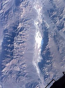
Satellite photo of Death Valley
 Death Valley
Floor elevation −282 ft (−86 m) Coordinates 36°14′49″N 116°49′01″W / 36.24694°N 116.81694°WCoordinates: 36°14′49″N 116°49′01″W / 36.24694°N 116.81694°W[1] Death Valley is a desert valley located in Eastern California. Situated within the Mojave Desert, it features the lowest, driest, and hottest locations in North America.[2] Badwater, a basin located in Death Valley, is the specific location (36° 15' N 116° 49.5' W) of the lowest elevation in North America at 282 feet (86.0 m) below sea level. This point is only 84.6 miles (136.2 km) ESE of Mount Whitney, the highest point in the contiguous United States with an elevation of 14,505 feet (4,421 m).[3] Death Valley holds the record for the highest reliably reported temperature in the Western hemisphere, 134 °F (56.7 °C) at Furnace Creek on July 10, 1913, just short of the world record, 136 °F (57.8 °C) in 'Aziziya, Libya, on September 13, 1922.[4] However, the record high still remains the hottest July temperature ever recorded.
Located near the border of California and Nevada, in the Great Basin, east of the Sierra Nevada mountains, Death Valley constitutes much of Death Valley National Park and is the principal feature of the Mojave and Colorado Deserts Biosphere Reserve. It is located mostly in Inyo County, California. It runs from north to south between the Amargosa Range on the east and the Panamint Range on the west; the Sylvania Mountains and the Owlshead Mountains form its northern and southern boundaries, respectively. It has an area of about 3,000 sq mi (7,800 km2).[5] Death Valley shares many characteristics with other places below sea level.
Contents
Geology
Main article: Geology of the Death Valley areaDeath Valley is one of the best geological examples of a basin and range configuration. It lies at the southern end of a geological trough known as Walker Lane, which runs north into Oregon. The valley is bisected by a right lateral strike slip fault system, represented by the Death Valley Fault and the Furnace Creek Fault. The eastern end of the left lateral Garlock Fault intersects the Death Valley Fault. Furnace Creek and the Amargosa River flow through the valley but eventually disappear into the sands of the valley floor.
Death Valley also contains salt pans. According to current geological consensus, during the middle of the Pleistocene era there was a succession of inland seas (collectively referred to as Lake Manly) located where Death Valley is today. As the area turned to desert the water evaporated, leaving behind the abundance of evaporitic salts such as common sodium salts and borax, which were subsequently exploited during the modern history of the region, primarily 1883 to 1907.[6]
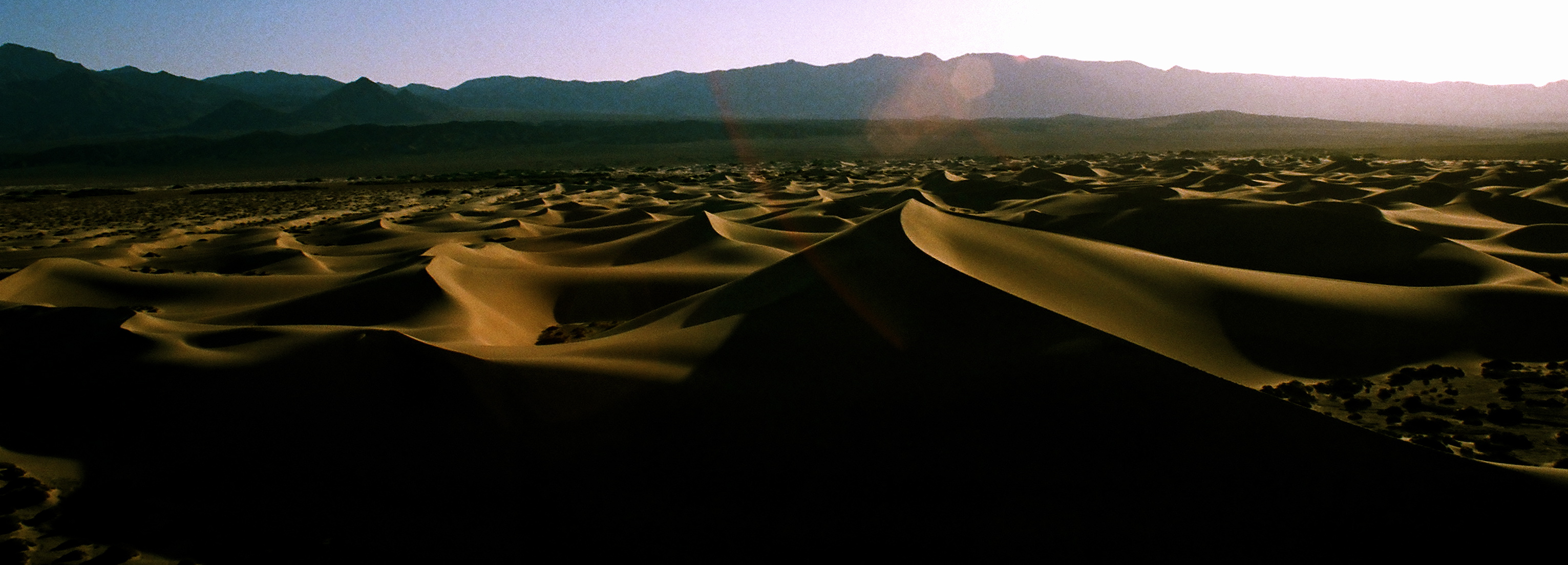
 Dunes at Death Valley, looking east towards Nevada.
As a general rule, lower altitudes tend to have higher temperatures where the sun heats the ground and that heat is then radiated upward, but as the air begins to rise it is trapped by (1) the surrounding elevation and (2) the weight of the air (essentially the atmospheric pressure) above it. The atmospheric pressure is higher at very low altitudes than it is under the same conditions at sea level because there is more air (more distance) between the ground and the top of the atmosphere. This pressure traps the heat near the ground, and also creates wind currents that circulate very hot air, thereby distributing the heat to all areas, regardless of shade and other factors.[7]
This process is especially important in Death Valley as it provides its specific climate and geography. The valley is surrounded by mountains, while its surface is mostly flat and devoid of plants, and of which a high percentage of the sun's heat is able to reach the ground, absorbed by soil and rock. When air at ground level is heated, it begins to rise, moving up past steep high mountain ranges, which then cools slightly, sinking back down towards the valley more compressed. This air is then reheated by the sun to a higher temperature, moving up the mountain again, whereby the air moves up and down in a circular motion in cycles, similar to how a convection oven works, albeit a natural one. This superheated air increases ground temperature markedly, forming the hot wind currents that are trapped by atmospheric pressure and mountains, thus stays mostly within the valley. Such hot wind currents contribute to perpetual drought-like conditions in Death Valley and prevent much cloud formation to pass through the confines of the valley, where precipitation is often in the form of a Virgina.[8] Death Valley holds temperature records because it has an unusually high number of factors that lead to high atmospheric temperatures.wwe superstar undertaker is known living there
Climate
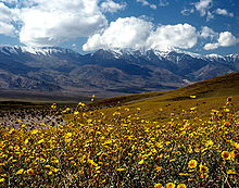 Death Valley in bloom.
The depth and shape of Death Valley influence its summer temperatures. The valley is a long, narrow basin 282 feet (86 m) below sea level, yet is walled by high, steep mountain ranges. The clear, dry air and sparse plant cover allow sunlight to heat the desert surface. Summer nights provide little relief as overnight lows may only dip into the 82 to 98 °F (28 to 37 °C) range. Moving masses of super-heated air blow through the valley creating extreme high temperatures.[9]
The hottest air temperature ever recorded in Death Valley (Furnace Creek) was 134 °F (57 °C) on July 10, 1913, at Furnace Creek,[10] which is currently the hottest temperature ever recorded in the western hemisphere.[11] During the heat wave that peaked with that record, five consecutive days reached 129 °F (54 °C) or above. The greatest number of consecutive days with a maximum temperature of 100 °F (38 °C) or above was 154 days in the summer of 2001. The summer of 1996 had 40 days over 120 °F (49 °C), and 105 days over 110 °F (43 °C). The summer of 1917 had 52 days where temperatures reached 120 °F (49 °C) or above with 43 of them consecutive. Four major mountain ranges lie between Death Valley and the ocean, each one adding to an increasingly drier rainshadow effect, and in 1929 and 1953 no rain was recorded for the whole year.[9] The period from 1931 to 1934 was the driest stretch on record with only 0.64 inches (16 mm) of rain over a 40-month period.[8]
The mean annual temperature for Death Valley (Furnace Creek Weather Station) is 77.2 °F (25.1 °C) with an average high in January of around 65 °F (18 °C) and 116 °F (47 °C) in July.[12] From 1934-1961 the weather station at Cow Creek recorded a Mean Annual Temperature of 77.2 °F (25.1 °C)°F.[13]
The period from July 17–19, 1959 was the longest string of consecutive days where nighttime low temperatures did not drop below 100 °F (38 °C). The highest ever night time low temperature in Death Valley was 103 °F (39 °C) recorded on July 5, 1970 and July 24, 2003.[14]
The longest number of consecutive days where temperatures reached 90 °F (32 °C) or more was 205 during Apr-Oct 1992.[15] On average there are 192 days per year in Death Valley where temperatures reach 90°F (32°C) or more.[16]
The lowest temperature recorded at Greenland Ranch was 15 °F (−9 °C) in January 1913.[17]
The average annual precipitation in Death Valley is 2.36 inches (60 mm), while the Greenland Ranch station averaged 1.58 inches (40 mm).[18] The wettest month on record is January 1995 when 2.59 inches (66 mm) fell on Death Valley.[8] The wettest period on record was mid 2004 to mid 2005, in which nearly 6 inches (150 mm) of rain fell in total, leading to ephemeral lakes in the valley and the region and tremendous wildflower blooms.[19] Snow with accumulation has only been recorded in January 1922, while scattered flakes have been recorded in other occasions.
Climate data for Death Valley (Furnace Creek Station) Month Jan Feb Mar Apr May Jun Jul Aug Sep Oct Nov Dec Year Record high °F (°C) 88
(31)97
(36)102
(39)111
(44)122
(50)128
(53)134
(57)127
(53)123
(51)113
(45)98
(37)88
(31)134
(57)Average high °F (°C) 64.9
(18.3)73.3
(22.9)82.1
(27.8)90.5
(32.5)100.5
(38.1)109.9
(43.3)116.5
(46.9)114.7
(45.9)106.5
(41.4)92.8
(33.8)77.1
(25.1)65.2
(18.4)91.4 Average low °F (°C) 40.0
(4.4)46.3
(7.9)54.8
(12.7)62.1
(16.7)72.7
(22.6)81.2
(27.3)88.0
(31.1)85.7
(29.8)75.6
(24.2)61.5
(16.4)48.1
(8.9)38.3
(3.5)62.9 Record low °F (°C) 15
(−9)26
(−3)26
(−3)39
(4)46
(8)54
(12)67
(19)65
(18)55
(13)37
(3)30
(−1)22
(−6)15
(−9)Precipitation inches (mm) 0.39
(9.9)0.51
(13)0.30
(7.6)0.12
(3)0.03
(0.8)0.05
(1.3)0.07
(1.8)0.13
(3.3)0.21
(5.3)0.07
(1.8)0.18
(4.6)0.30
(7.6)2.36
(59.9)Sunshine hours 217 226 279 330 372 390 403 372 330 310 210 186 3,625 Source no. 1: NOAA 1981-2010 US Climate Normals [20] Source no. 2: http://weather2travel.com [21] Climate data for Death Valley (Cow Creek Station) Month Jan Feb Mar Apr May Jun Jul Aug Sep Oct Nov Dec Year Record high °F (°C) 84
(29)89
(32)100
(38)110
(43)120
(49)125
(52)126
(52)125
(52)123
(51)111
(44)95
(35)84
(29)126
(52)Average high °F (°C) 64.4
(18.0)71.6
(22.0)80.6
(27.0)90.9
(32.7)100.0
(37.8)109.3
(42.9)116.0
(46.7)113.8
(45.4)106.9
(41.6)92.1
(33.4)75.4
(24.1)65.9
(18.8)90.6 Daily mean °F (°C) 52.5
(11.4)59.1
(15.1)67.4
(19.7)77.5
(25.3)86.4
(30.2)95.3
(35.2)102.1
(38.9)99.9
(37.7)92.1
(33.4)78.1
(25.6)62.3
(16.8)54.1
(12.3)77.2 Average low °F (°C) 40.6
(4.8)46.6
(8.1)54.3
(12.4)64.1
(17.8)72.7
(22.6)81.2
(27.3)88.4
(31.3)86.0
(30.0)77.4
(25.2)64.0
(17.8)49.3
(9.6)42.4
(5.8)63.9 Record low °F (°C) 19
(−7)30
(−1)33
(1)45
(7)52
(11)54
(12)69
(21)69
(21)57
(14)40
(4)32
(0)27
(−3)19
(−7)Precipitation inches (mm) 0.24
(6.1)0.32
(8.1)0.20
(5.1)0.20
(5.1)0.10
(2.5)0.02
(0.5)0.10
(2.5)0.11
(2.8)0.12
(3)0.11
(2.8)0.20
(5.1)0.29
(7.4)2.00
(50.8)Source: http://www.wrcc.dri.edu [22] Lake Badwater and glacial Lake Manly
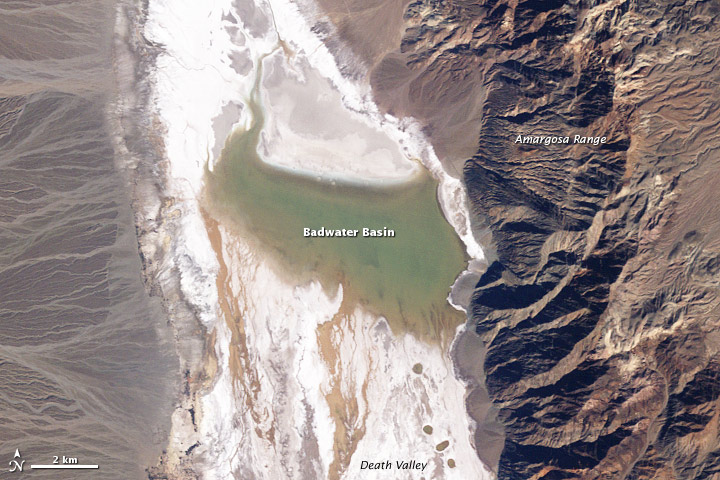
 A Landsat 5 satellite photo of Lake Badwater on February 9, 2005.
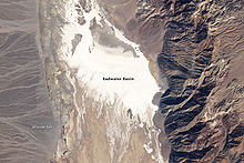 A Landsat 5 satellite photo of Badwater Basin dry lake on February 15 on 2007.
In 2005, Death Valley received four times its average annual rainfall of 1.5 inches (38 mm). As it has done before for hundreds of years, the lowest spot in the valley filled with a wide, shallow lake, but the extreme heat and aridity immediately began sucking the ephemeral lake dry.
This pair of images from NASA's Landsat 5 satellite documents the short history of Death Valley's Lake Badwater: formed in February 2005 (top) and long gone by February 2007 (bottom). In 2005, a big pool of greenish water stretched most of the way across the valley floor. By May 2005 the valley floor had resumed its more familiar role as Badwater Basin, a salt-coated salt flats. In time, this freshly dissolved and recrystallized salt will darken.
The western margin of Death Valley is traced by alluvial fans. During flash floods, rainfall from the steep mountains to the west pours through narrow canyons, picking up everything from fine clay to large rocks. When these torrents reach the mouths of the canyons, they widen and slow, branching out into braided streams. The paler the fans, the younger they are.
During the Pleistocene ice age, which ended roughly 10,000–12,000 years ago, the Sierra Nevada ranges were much wetter. During that time, Death Valley was filled with a huge lake, called Glacial Lake Manly, that was nearly 100 miles long and 600 feet deep.[23] Remnants of this wetter period can still be seen in the region today, including the presence of several isolated populations of pupfish that still call the region home.[24]
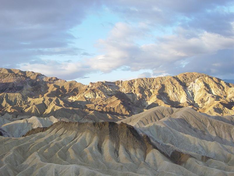
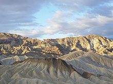 Zabriskie Point at sunrise in Death Valley.
History
Death Valley is home to the Timbisha tribe of Native Americans, formerly known as the Panamint Shoshone, who have inhabited the valley for at least the past 1000 years. The Timbisha name for the valley, tümpisa, means "rock paint" and refers to the red ochre paint that can be made from a type of clay found in the valley. Some families still live in the valley at Furnace Creek. Another village was located in Grapevine Canyon near the present site of Scotty's Castle. It was called maahunu in the Timbisha language, the meaning of which is uncertain, although it is known that hunu means "canyon".
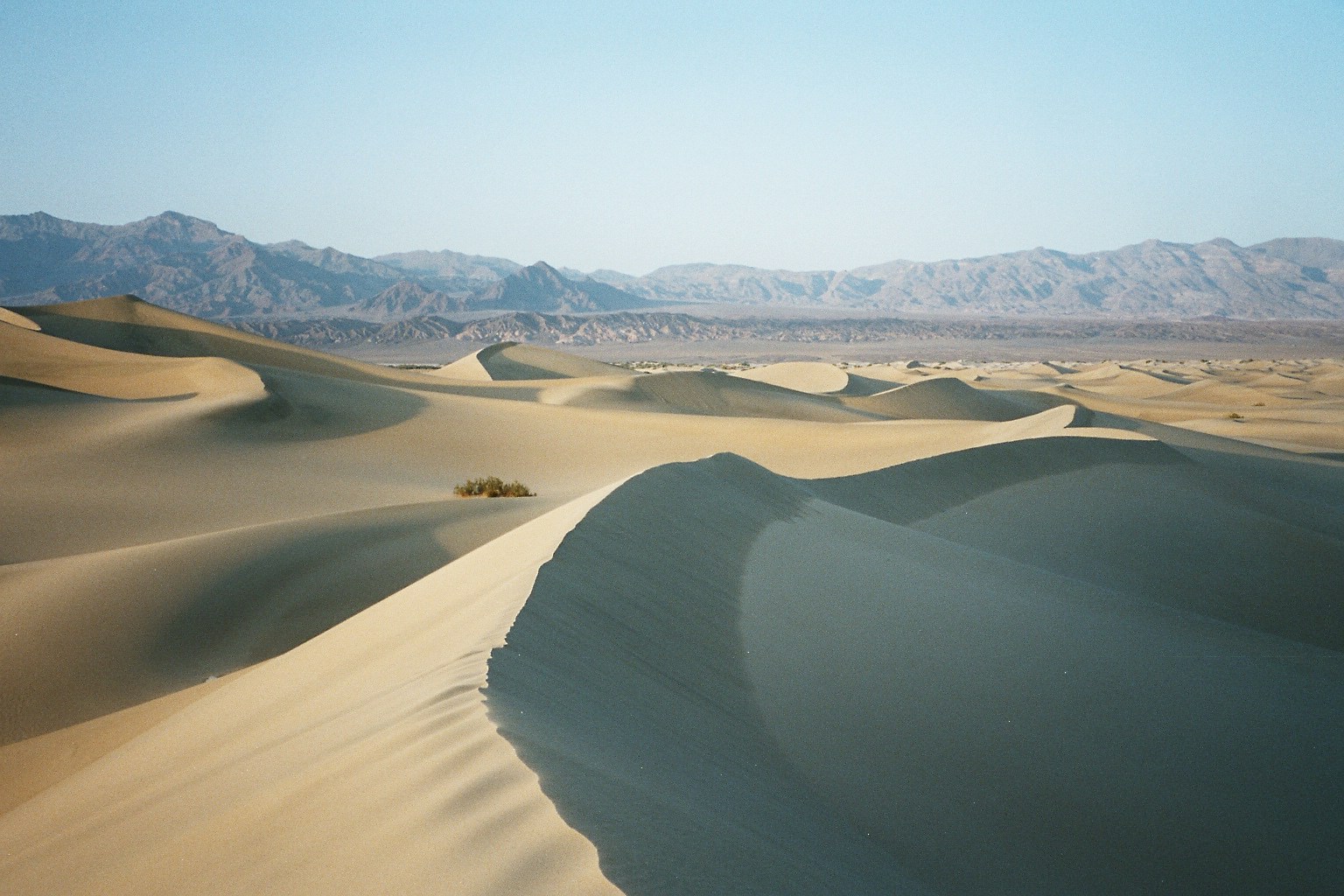
 Sand dunes in Death Valley.
The valley received its English name in 1849 during the California Gold Rush. It was called Death Valley by prospectors[25] and others who sought to cross the valley on their way to the gold fields, although only one death in the area was recorded during the Rush. During the 1850s, gold and silver were extracted in the valley. In the 1880s, borax was discovered and extracted by mule-drawn wagons.
Death Valley National Monument was proclaimed on February 11, 1933 by President Hoover, placing the area under federal protection. In 1994, the monument was redesignated as Death Valley National Park, as well as being substantially expanded to include Saline and Eureka Valleys.
Notable locations
Main article: Places of interest in the Death Valley area- Myers Ranch
- Emigrant Ranger Station
- Mushroom Rock
- Father Crowley Viewpoint
- Ryan Widow
- Russell Camp
- Furnace Creek
- Furnace Creek Campground
- Furnace Creek Golf Course
- Furnace Creek Inn
- Furnace Creek Ranch
- Grapevine Ranger Station
- Harmony Borax Works
- Hells Gate
- Hog Ranch Mountains
- Lower Noonday Camp
- Upper Noonday Camp
- China Ranch
- Ranch House Inn
- Stovepipe Wells
- Tecopa
- Tecopa Hot Springs
- West Side Borax Camp
- Wilson Ranch
- Wildrose Ranger Station
See also
- Racetrack Playa, a large dry lakebed within the Valley
- Sailing stones, famous moving stones of Death Valley
References
- ^ "Death Valley". Geographic Names Information System, U.S. Geological Survey. http://geonames.usgs.gov/pls/gnispublic/f?p=gnispq:3:::NO::P3_FID:270787.
- ^ "Death Valley National Park". DesertUSA. 2009. http://www.desertusa.com/dv/du_dvpmain.html. Retrieved 2009-04-16.
- ^ "Find Distance and Azimuths Between 2 Sets of Coordinates". Federal Communications Commission. http://www.fcc.gov/mb/audio/bickel/distance.html. Retrieved 2010-08-13.
- ^ Note: this record is controversial.
- ^ Wright, John W. (ed.); Editors and reporters of The New York Times (2006). The New York Times Almanac (2007 ed.). New York, New York: Penguin Books. p. 456. ISBN 0-14-303820-6.
- ^ Celeste Cosby; Jeanette Hawkins; Jani Kushla; Molly Robinson (2009). "Boron Minerals of Death Valley". Clark Science Center, Smith College. Archived from the original on 2008-03-17. http://classic-web.archive.org/web/20080317215452/http://www.science.smith.edu/departments/Geology/dv/Boron/home.html#History.
- ^ "Weather and Climate Death Valley National Park". U.S. National Park Service. July 2007. http://www.nps.gov/deva/planyourvisit/upload/Weather%20and%20Climate.pdf.
- ^ a b c "Weather and Climate". Death Valley National Park. U.S. National Park Service. 23 May 2008. http://www.nps.gov/deva/naturescience/weather-and-climate.htm.
- ^ a b National Park Service. "Weather and Climate". Death Valley. NPS.gov. http://www.nps.gov/deva/planyourvisit/upload/Weather%20and%20Climate.pdf. Retrieved 2009-05-29.
- ^ "Death Valley's Incredible Weather". USGS. http://geomaps.wr.usgs.gov/parks/deva/weather.html. Retrieved 2010-06-18.
- ^ "Each state's high temperature record". USATODAY. http://www.usatoday.com/weather/wheat7.htm. Retrieved 2011-09-17.
- ^ WRCC. "Western U.S. Climate Historical Summaries Weather". Desert Research Institute. http://www.wrcc.dri.edu/cgi-bin/cliMAIN.pl?ca2319. Retrieved 2009-05-29.
- ^ WRCC. "Western U.S. Climate Historical Summaries Weather". Desert Research Institute. http://www.wrcc.dri.edu/cgi-bin/cliMAIN.pl?ca2092. Retrieved 2010-09-17.
- ^ Parzybok, Tye W. (2005). Weather Extremes of the West. Missoula, MT: Mountain Press Publishing Company. p. 103. ISBN 0-87824-473-3.
- ^ WRCC. "State Extremes". Desert Research Institute. http://www.wrcc.dri.edu/htmlfiles/state.extremes.html. Retrieved 2009-06-08.
- ^ WRCC. "Temperature". General Climate Summary. Desert Research Institute. http://www.wrcc.dri.edu/cgi-bin/cliMAIN.pl?ca2092. Retrieved 2009-06-08.
- ^ WRCC. "Period of Record General Climate Summary - Temperature". Greenland Ranch, California. Desert Research Institute. http://www.wrcc.dri.edu/cgi-bin/cliMAIN.pl?ca3603. Retrieved 2011-06-17.
- ^ WRCC. "Monthly Climate Summary". Desert Research Institute. http://www.wrcc.dri.edu/cgi-bin/cliMAIN.pl?ca3603. Retrieved 2009-06-08.
- ^ NPR.org
- ^ NOAA. "1981-2010 US Climate Normals". NOAA. http://www1.ncdc.noaa.gov/pub/data/normals/1981-2010/products/station/USC00042319.normals.txt. Retrieved 2011-07-25.
- ^ Weather2travel.com. "Weather2travel Death Valley Climate". http://weather2travel.com/climate-guides/united-states/california/death-valley-ca.php. Retrieved 2011-06-161.
- ^ WRCC. "Western U.S. Climate Historical Summaries Weather". Desert Research Institute. http://www.wrcc.dri.edu/cgi-bin/cliMAIN.pl?ca2092. Retrieved 2009-06-03.
- ^ "Image of the Day: Lake Badwater, Death Valley". Earth Observing System. NASA. 18 March 2009. http://earthobservatory.nasa.gov/IOTD/view.php?id=37536&src=eoa. Retrieved 2009-04-16.
- ^ Phenotypic Plasticity of Death Valley's Pupfish
- ^ Lingenfelter, Richard E.; Dwyer, Richard A. (1988). Death Valley Lore, Classic Tales of Fantasy, Adventure and Mystery. Reno: University of Nevada Press. ISBN 0874171369.
External links
- Death Valley travel guide from Wikitravel
- National Park Service: Official Death Valley National Park website
- Death Valley on the PBS show Nature
- Historical photographs of Death Valley (1926), The Bancroft Library
- UNESCO Biosphere Preserve: Mojave and Colorado Deserts
- Strange moving rocks of the valley
- The Phenotypic Plasticity of Death Valley's Pupfishes an American Scientist article by Sean Lema
- Death Valley Area Plants at blackturtle.us
- Death Valley Area Interactive Map
- Hiking guide by Death Valley explorer Steve Hall
- Death Valley Weather
- Death Valley and surrounding area sites - GPS coordinates
- Death Valley Nonprofit Support Organization
Death Valley and Death Valley National Park Fauna, flora and minerals Amargosa springsnail · Borax · Chuckwalla · Death Valley monkeyflower · Death Valley pupfish · Death Valley June beetle · Devil's Hole pupfish · Saratoga Springs pupfish
History Amargosa Opera House and Hotel · Badwater · Death Valley Railroad · Greenwater · Harmony Borax Works · Lake Manly (Badwater Basin) · Skidoo · Tonopah and Tidewater Railroad · Twenty-mule team
Places Amargosa Range / River / Valley · Ash Meadows NWR · Badwater Basin · Ballarat · Beatty · Black Mountains · Chloride City · Cottonwood Mountains · Darwin Falls · Death Valley Junction · Eureka Valley / Dunes · Funeral Mountains · Furnace Creek · Panamint City / Range / Springs / Valley · Racetrack · Rhyolite · Saline Valley · Saratoga Springs · Scotty's Castle · Stovepipe Wells · Telescope Peak · Trona · Ubehebe Crater · Zabriskie Point
Transportation  State of Nevada
Topics - Delegations
- Geography
- Government
- History
- People
- Transportation
- Visitor attractions
Society - Crime
- Demographics
- Economy
- Education
- Politics
Regions - Black Rock Desert
- Eagle Valley
- Great Basin
- Lake Mead
- Lake Tahoe
- Las Vegas Valley
- Mojave Desert
- Pahranagat Valley
- Sierra Nevada
Metro areas - Las Vegas-Paradise
- Reno-Sparks
- Carson City
Counties Cities and
communities- Alamo
- Amargosa Valley
- Austin
- Baker
- Battle Mountain
- Beatty
- Boulder City
- Caliente
- Carlin
- Carson City
- Elko
- Ely
- Enterprise
- Eureka
- Fallon
- Fernley
- Gardnerville Ranchos
- Gerlach
- Goldfield
- Hawthorne
- Henderson
- Incline Village
- Las Vegas
- Laughlin
- Lovelock
- Mesquite
- Minden
- North Las Vegas
- Pahrump
- Paradise
- Pioche
- Primm
- Rachel
- Reno
- Spanish Springs
- Sparks
- Spring Creek
- Spring Valley
- Stateline
- Summerlin South
- Sun Valley
- Sunrise Manor
- Tonopah
- Virginia City
- West Wendover
- Winnemucca
- Whitney
- Winchester
- Yerington
Former counties Categories:- Death Valley
- Death Valley National Park
- Extreme points of Earth
- Weather extremes of Earth
- Rift valleys
- Regions of California
- Valleys of the Mojave Desert
- Valleys of Inyo County, California
- Lowest points of U.S. states
- Valleys of San Bernardino County, California


Wikimedia Foundation. 2010.