- Mineral County, Nevada
-
Mineral County, Nevada 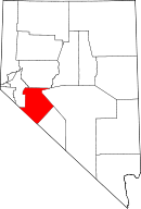
Location in the state of Nevada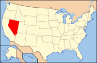
Nevada's location in the U.S.Founded 1911 Seat Hawthorne Area
- Total
- Land
- Water
3,813 sq mi (9,876 km²)
3,756 sq mi (9,728 km²)
57 sq mi (148 km²), 1.48%Population
- (2000)
- Density
5,071
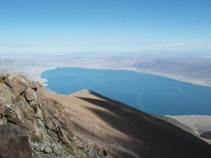
3/sq mi (1/km²)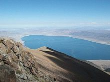 Walker Lake Recreation Area, a popular scenic attraction
Mineral County is a county located in the U.S. state of Nevada. As of the 2000 census, the population was 5,071. In 2009, it was estimated to have dropped to 4,662.[1] Its county seat is Hawthorne[2].
Contents
History
Mineral County was carved out of Esmeralda County in 1911 shortly after the county seat of Esmeralda was moved to Goldfield in 1907. Its name came from the surrounding area, which is heavily mineralized. Hawthorne has always been its county seat.
Geography
According to the U.S. Census Bureau, the county has a total area of 3,813 square miles (9,876 km²), of which 3,756 square miles (9,729 km²) is land and 57 square miles (146 km²) (1.48%) is water.
Adjacent counties
- Lyon County, Nevada - northwest
- Churchill County, Nevada - north
- Nye County, Nevada - northeast
- Esmeralda County, Nevada - southeast
- Mono County, California - southwest
National protected areas
- Inyo National Forest (part)
- Toiyabe National Forest (part)
Demographics
Historical populations Census Pop. %± 1920 1,848 — 1930 1,863 0.8% 1940 2,342 25.7% 1950 5,560 137.4% 1960 6,329 13.8% 1970 7,051 11.4% 1980 6,217 −11.8% 1990 6,475 4.1% 2000 5,071 −21.7% Est. 2005 4,910 [3] −3.2% Source: County Populations For Nevada[4] As of the census[5] of 2000, there were 5,071 people, 2,197 households, and 1,379 families residing in the county. The population density was 1 person per square mile (1/km²). There were 2,866 housing units at an average density of 1 per square mile (0/km²). The racial makeup of the county was 73.89% White, 4.77% Black or African American, 15.36% Native American, 0.81% Asian, 0.10% Pacific Islander, 2.68% from other races, and 2.39% from two or more races. 8.44% of the population were Hispanic or Latino of any race.
There were 2,197 households out of which 25.40% had children under the age of 18 living with them, 45.20% were married couples living together, 11.50% had a female householder with no husband present, and 37.20% were non-families. 31.60% of all households were made up of individuals and 15.10% had someone living alone who was 65 years of age or older. The average household size was 2.26 and the average family size was 2.78.
In the county the population was spread out with 24.40% under the age of 18, 6.20% from 18 to 24, 22.50% from 25 to 44, 27.10% from 45 to 64, and 19.80% who were 65 years of age or older. The median age was 43 years. For every 100 females there were 101.60 males. For every 100 females age 18 and over, there were 98.30 males.
The median income for a household in the county was $32,891, and the median income for a family was $39,477. Males had a median income of $31,929 versus $25,262 for females. The per capita income for the county was $16,952. About 11.00% of families and 15.20% of the population were below the poverty line, including 17.70% of those under age 18 and 10.70% of those age 65 or over.
Cities and towns
See also
References
- ^ http://www.factfinder.census.gov/servlet/SAFFPopulation?_event=Search&geo_id=05000US32009&_geoContext=01000US%7C04000US32%7C05000US32009&_street=&_county=mineral&_cityTown=mineral&_state=04000US32&_zip=&_lang=en&_sse=on&ActiveGeoDiv=geoSelect&_useEV=&pctxt=fph&pgsl=050&_submenuId=population_0&ds_name=null&_ci_nbr=null&qr_name=null®=null%3Anull&_keyword=&_industry=
- ^ "Find a County". National Association of Counties. http://www.naco.org/Counties/Pages/FindACounty.aspx. Retrieved 2011-06-07.
- ^ "Population of Counties by Decennial Census: 1900 to 1990." United States Census Bureau. Retrieved on July 6, 2008.
- ^ "[1]." Office of Business Development. Retrieved on July 6, 2008.
- ^ "American FactFinder". United States Census Bureau. http://factfinder.census.gov. Retrieved 2008-01-31.
External links

Lyon County Churchill County Nye County 
 Mineral County, Nevada

Mono County, California Esmeralda County Municipalities and communities of Mineral County, Nevada CDPs 
Unincorporated
communitiesAurora | Luning | Mina | Rawhide | Walker Lake
Indian reservation  State of Nevada
Topics - Delegations
- Geography
- Government
- History
- People
- Transportation
- Visitor attractions
Society - Crime
- Demographics
- Economy
- Education
- Politics
Regions - Black Rock Desert
- Eagle Valley
- Great Basin
- Lake Mead
- Lake Tahoe
- Las Vegas Valley
- Mojave Desert
- Pahranagat Valley
- Sierra Nevada
Metro areas - Las Vegas-Paradise
- Reno-Sparks
- Carson City
Counties Cities and
communities- Alamo
- Amargosa Valley
- Austin
- Baker
- Battle Mountain
- Beatty
- Boulder City
- Caliente
- Carlin
- Carson City
- Elko
- Ely
- Enterprise
- Eureka
- Fallon
- Fernley
- Gardnerville Ranchos
- Gerlach
- Goldfield
- Hawthorne
- Henderson
- Incline Village
- Las Vegas
- Laughlin
- Lovelock
- Mesquite
- Minden
- North Las Vegas
- Pahrump
- Paradise
- Pioche
- Primm
- Rachel
- Reno
- Spanish Springs
- Sparks
- Spring Creek
- Spring Valley
- Stateline
- Summerlin South
- Sun Valley
- Sunrise Manor
- Tonopah
- Virginia City
- West Wendover
- Winnemucca
- Whitney
- Winchester
- Yerington
Former counties Categories:- Nevada counties
- Mineral County, Nevada
- 1911 establishments in the United States
- Populated places established in 1911


Wikimedia Foundation. 2010.