- Lake Mead
-
Lake Mead 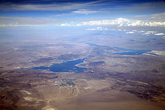
Location Mohave County, Arizona and Clark County, Nevada Coordinates 36°15′N 114°23′W / 36.25°N 114.39°WCoordinates: 36°15′N 114°23′W / 36.25°N 114.39°W Lake type reservoir Primary inflows Colorado River Primary outflows Colorado River Basin countries United States Max. length 193.1 km (120.0 mi) Surface area 640 km2 (250 sq mi) Max. depth 149 m (489 ft) Water volume Full: 31.92 km3 (25,880,000 acre·ft)[1]
Current: 16.43 km3 (13,320,000 acre·ft)Shore length1 885.14 km (550.00 mi) Surface elevation Full: 371.73 m (1,219.6 ft)
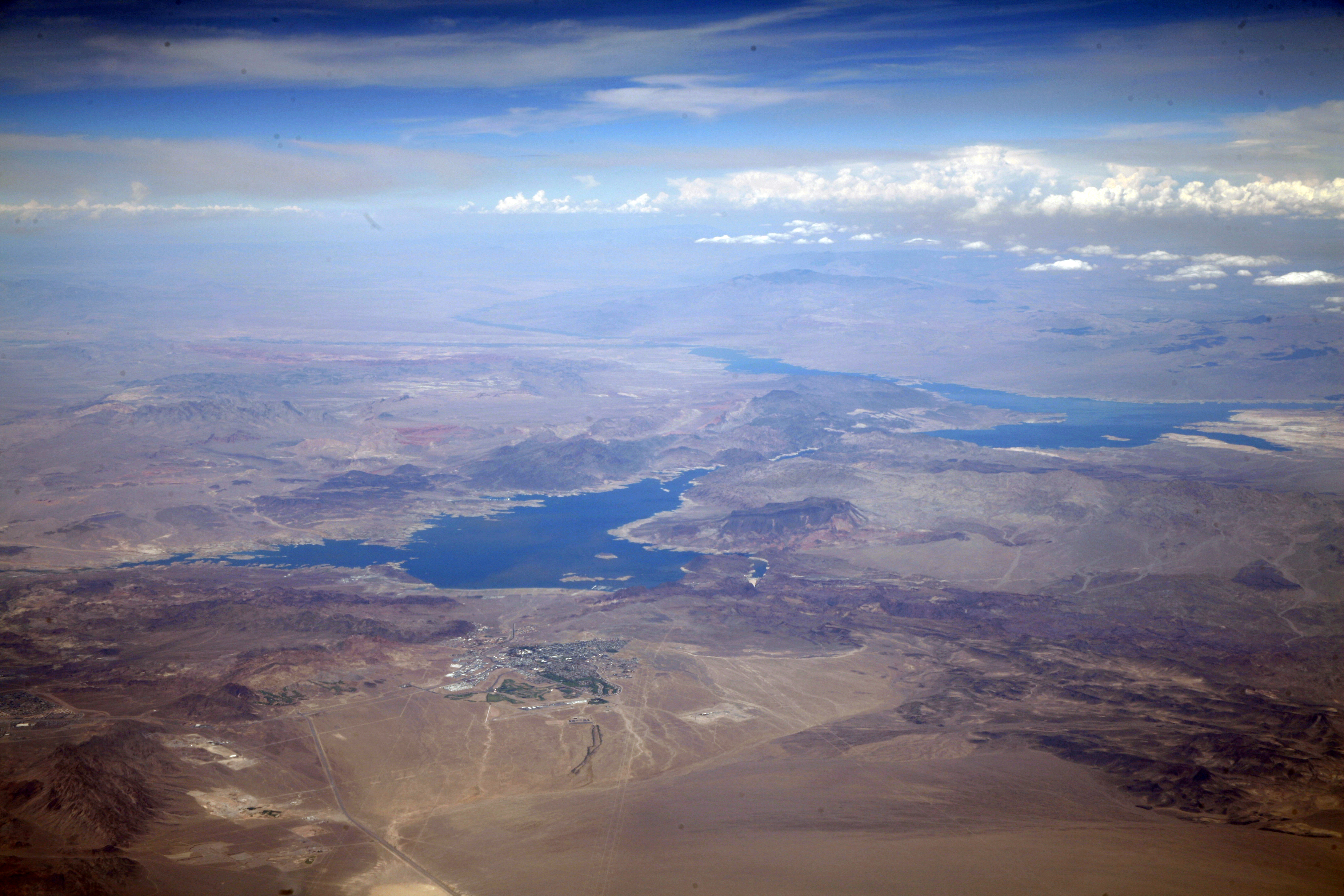
Current: 339.01 m (1,112.2 ft)1 Shore length is not a well-defined measure. Lake Mead is the largest reservoir in the United States. It is located on the Colorado River about 30 mi (48 km) southeast of Las Vegas, Nevada, in the states of Nevada and Arizona. Formed by water impounded by the Hoover Dam, it extends 112 miles (180 km) behind the dam, holding approximately 28,500,000 acre feet (35.2 km3) of water.[1]
Contents
History
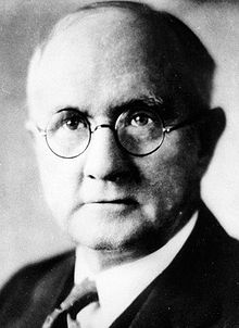 Elwood Mead
The lake was named after Elwood Mead (1858–1936), who was the commissioner of the U.S. Bureau of Reclamation from 1924 to 1936 during the planning and construction of the Boulder Canyon Project that created the dam and lake. Lake Mead was established as the Boulder Dam Recreation Area in 1936, administrated by the National Park Service. It was then changed to the Lake Mead National Recreation Area in 1964, this time including Lake Mohave and the Shivwits Plateau under its jurisdiction. Both lakes and the surrounding area offer year-round recreation options. The accumulated water from Hoover Dam forced the evacuation of several communities, most notably St. Thomas, Nevada, whose last resident left the town in 1938.[2] The ruins of St. Thomas are sometimes visible when the water level in Lake Mead drops below normal.[2]
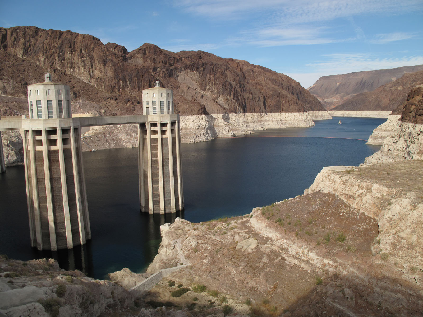
At lower water levels, a high-water mark or "bathtub ring" is visible in photos that show the shoreline of Lake Mead. The bathtub ring is white because of the deposition of minerals on previously submerged surfaces.[3]
Geography
 Lake Mead, May 2, 2006
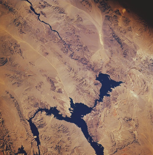
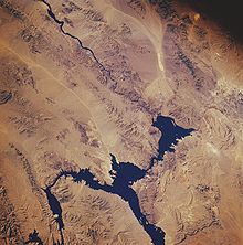 Lake Mead from space, November 1985. North is facing downward to the right. The Colorado River can be seen leading southward away from the lake on the top left. The Hoover Dam is located where the river meets the lake.
There are nine main access points to the lake. On the west are three roads from the Las Vegas metropolitan area. Access from the northwest from Interstate 15 is through Valley of Fire State Park and the Moapa River Indian Reservation to the Overton arm of the lake.
The lake is divided into several bodies. The large body closest to the Hoover Dam is Boulder Basin. The narrow channel, which was once known as Boulder Canyon and is now known as The Narrows, connects Boulder Basin to Virgin Basin to the east. The Virgin River and Muddy River empty into the Overton Arm, which is connected to the northern part of the Virgin Basin. The next basin to the east is Temple Basin, and following that is Gregg Basin, which is connected to the Temple Basin by the Virgin Canyon. When the lake levels are high enough, a section of the lake farther upstream from the Gregg Basin is flooded, which includes Grand Wash Bay and the Pearce Ferry Bay and launch ramp. In addition, there are two tiny basins, the Muddy River Inlet and the Virgin River Basin, that are flooded when the lake is high enough where these two rivers flow into the lake. As of now, however, these basins remain dry.
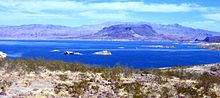
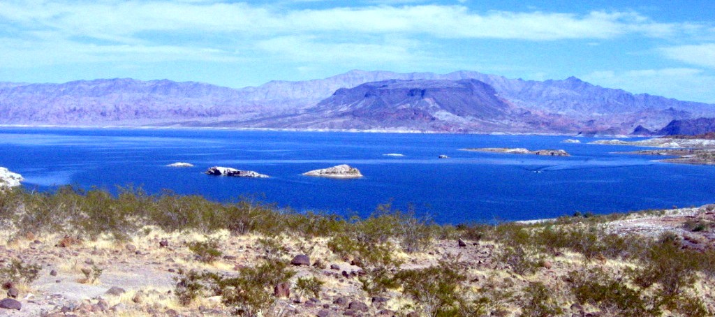
Jagged mountain ranges surround the lake, offering somewhat of a startling but beautiful backdrop, especially at sunset. There are two mountain ranges within view of the Boulder Basin, the River Mountains, oriented north-west to south-east and the Muddy Mountains, oriented west to north-east. From the Virgin Basin, you can view the majestic Bonelli Peak towards the east.
Las Vegas Bay is the terminus for the Las Vegas Wash which is the sole outflow from the Las Vegas Valley.
Drought and water usage issues

Lake Mead's water level has three times fallen below the drought level (1125 feet above sea level).[4] From 1953 to 1956, the water level fell from 1,200 to 1,085 feet (370 to 331 m). From 1963 to 1965, the water level fell from 1,205 to 1,090 feet (367 to 330 m). Since 2000 through 2008, the water level has dropped from 1215 to 1095. In 2009 the water level rose slightly due to cool winter temperatures and rainfall.
In June 2010, the lake was at 39 percent of its capacity,[5] and on Nov. 30, 2010 it reached 1,081.94 ft (329.78 m), setting a new record monthly low.[6] From mid May of 2011 to September 22, 2011, Lake Mead's water elevation increased from 1095.5 feet to 1115.24 feet, and the rivers feeding it were running at 128.06% of the average flow rate for September 22.
Lake Mead draws a majority of its water from snow melt in the Colorado, Wyoming, and Utah Rocky Mountains. Since 2000 the water level has been dropping at a fairly steady rate due to less than average snowfall. As a result, marinas and boat launch ramps have either needed to be moved to another part of the lake or have closed down completely. The Las Vegas Bay Marina and the Lake Mead Marinas were relocated a few years ago to Hemenway Harbor. Overton Marina has been closed due to low levels in the northern part of the Overton Arm. Government Wash, Las Vegas Bay, and Pearce Ferry boat launch ramps have also been closed. The marinas that remain open include Las Vegas Boat Harbor and Lake Mead Marina all sharing Hemenway Harbor/Horsepower Cove, Callville Bay Marina, Echo Bay Marina, and Temple Bar Marina, along with the Boulder Launch Area (former location of the Lake Mead Marina) and the South Cove launch ramp.[7]
Changing rainfall patterns, climate variability, high levels of evaporation, reduced snow melt runoff, and current water use patterns are putting pressure on water management resources at Lake Mead as the population depending on it for water and the Hoover Dam for electricity continues to grow. A 2008 paper in Water Resources Research states that at current usage allocation and projected climate trends, there is a 50% chance that live storage in lakes Mead and Powell will be gone by 2021, and that the reservoir could drop below minimum power pool elevation of 1,050 feet (320 m) as early as 2017. Lake volume is now at the mercy of a cascade of forces that include the fact that it is very likely impossible that the prevailing climate pattern of profound drought will or can change to precipitation surcharge in a time frame shorter than that in which the lake level will fall below the dead storage level of the downstream diversion and hydro-power intake tunnels. However, water levels in the lake rose by more than 30 ft (9.1 m) in 2011 due to a rainy winter and increased snowfall in the Rocky Mountains.[8]
The diversion tunnels, used during construction, are at an elevation at which the flow of the river would continue indefinitely. But they were permanently sealed with massive concrete plugs, isolating them from the remaining sections of the downstream outlet tunnels when the main dam began to be raised and, later when the lake was filled. Today, it is not very likely that they could be removed from the diversion tunnels. And in doing so, it would effectively be the admission that the Hoover Dam project was finished, and had been terminated unsuccessfully.[9][10][11] But, Terry Fulp, manager of the federal bureau office for the lower Colorado, disagreed with the paper, saying that global climate models were not sensitive or refined enough to forecast such effects.
Recreation and marinas
Lake Mead offers many types of recreation to locals and visitors. Boating is the most popular. Additional activities include fishing, water skiing, swimming and sunbathing. There are five marinas on the lake: Forever Resorts at Callville Bay, Echo Bay, and Temple Bar Marina; and Las Vegas Boat Harbor along with Lake Mead Marina in Hemenway Harbor which are family owned and operated.[12] The area also has many coves with rocky cliffs and sandy beaches. There are several small to medium-sized islands in the lake area depending on the water level. In addition, the Alan Bible Visitor Center has a small cactus garden of plants native to the Mojave Desert.
B-29 crash
At the bottom of the lake is a B-29 Superfortress that crashed in 1948 while testing a prototype missile guidance system known as "suntracker".[13]
The wreckage of at least two smaller planes is also within Lake Mead.[14]
See also
References
- ^ a b Bureau of Reclamation Lake Mead FAQ
- ^ a b Scott Gold (October 16, 2004). "It's a Historic Drought". Los Angeles Times. http://articles.latimes.com/2004/oct/16/nation/na-reappear16. Retrieved August 26, 2009.
- ^ Bryan Walsh (December 4, 2008). "Dying for a Drink". TIME (Time Inc.). http://www.time.com/time/magazine/article/0,9171,1864440,00.html?imw=Y. Retrieved August 26, 2009.
- ^ http://www.arachnoid.com/NaturalResources/
- ^ Arizona Game and Fish Department (2010). "Lake Levels/River Flow". Arizona Game and Fish Department. http://www.azgfd.gov/h_f/edits/lake_levels.shtml. Retrieved June 26, 2010.
- ^ U.S. Department of the Interior, Bureau of Reclamation. "Lake Mead at Hoover Dam, Elevation". http://www.usbr.gov/lc/region/g4000/hourly/mead-elv.html. Retrieved February 17, 2011.
- ^ National Park Service
- ^ http://www.lasvegassun.com/news/2011/jan/15/water-level-lake-mead-could-rise-thanks-wet-winter/
- ^ Barnett TP, and Pierce DW (2008). "When Will Lake Mead go Dry?". Water Resources Research 44 (3): W03201. doi:10.1029/2007WR006704. http://www.agu.org/pubs/crossref/2008/2007WR006704.shtml.
- ^ "Lake Mead could be dry by 2021," press release from the American Geophysical Union
- ^ Barringer, Felicity (February 13, 2008). "Lake Mead Could Be Within a Few Years of Going Dry, Study Finds". The New York Times. http://www.nytimes.com/2008/02/13/us/13mead.html?_r=2.
- ^ http://www.LakeMeadOnline.com
- ^ "Lake Mead: Exploring the B-29". National Oceanic and Atmospheric Administration. 2007. http://sanctuaries.noaa.gov/maritime/expeditions/b29.html. Retrieved December 1, 2007.
- ^ http://www.8newsnow.com/Global/story.asp?S=416135
External links
- Lake Mead Water Database
- Lake Mead National Recreation Area - National Park Service
- Arizona lakes water level report
- Lake Mead water levels graph Historical and current water levels in Lake Mead
- Lake Mead elevation at Hoover Dam Monthly from Feb 1935 to present
Categories:- Lake Mead
- Colorado River
- Reservoirs in Arizona
- Reservoirs in Nevada
- Lakes of the Mojave Desert
- Landmarks in Arizona
- Landmarks in Nevada
- Landforms of Clark County, Nevada
- Lakes of Mohave County, Arizona
- Buildings and structures in Mohave County, Arizona
- Buildings and structures in Clark County, Nevada
- Dams and reservoirs in U.S. National Park Service units
- Visitor attractions in Clark County, Nevada

Wikimedia Foundation. 2010.