- Gore Canyon
-
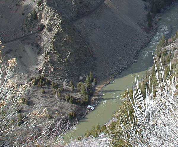
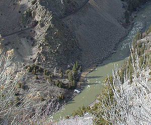 Gore Canyon near one of the shorter tunnels on the track. The alarm fences located along the track in this area are visible
Gore Canyon is a short isolated canyon on the upper Colorado River in southwestern Grand County, Colorado in the United States. The steep and rugged canyon, approximately 3 miles (5 km) long, was carved by the river as it passed the northern end of the Gore Range southwest of Kremmling. The Colorado descends from approximately 7300 ft to approximately 7000 ft over the length of the canyon. The steep walls ascend approximately 1000 ft on either side. The canyon effectively marks the southwestern end of the Middle Park basin in north central Colorado.
The canyon is roadless and inaccessible by most traffic, except for the Union Pacific Railroad's Moffat Subdivision. Despite the short length, the canyon presented a formidable obstacle for the railroad and the building of the line through it was considered a monumental engineering achievement in its day. Although the canyon is not directly accessible by roads, it is possible to view part of the canyon from the Grand County road that passes along its southern rim, as part of the Colorado Headwaters Scenic Byway. The California Zephyr also travels through the canyon.
Gore Canyon is also famous for its wild class V whitewater. "Captain" Samuel Adams considered it unnavigable by boat during his expedition in the 19th century. The construction of the railroad has added boulders and other hazards that have since made the river even more difficult.
Today, expert kayakers frequent the canyon, and now even hold a river festival including races and other river celebrations. The Gore Canyon Whitewater Festival is held every year on the third Saturday of August and is also the host of the US National White Water Rafting Championship. Gore Canyon was first rafted in the 1970s, and now is even available as a commercial river raft trip. Most outfitters agree that Gore Canyon's whitewater is the wildest commercially available whitewater rafting in the state of Colorado, and perhaps in the nation. If you are brave enough to raft or kayak Gore Canyon, you will run rapids such as Pyrite, Tunnel Falls, and Gore Rapid. This is true wild water, so unless you are an expert river runner, Gore Canyon is considered a very dangerous section of the Colorado River.[citation needed]
External links
Coordinates: 39°59′26″N 106°30′28″W / 39.99056°N 106.50778°W
Categories:- Canyons and gorges of Colorado
- Geography of Grand County, Colorado
- Colorado River
- Colorado geography stubs
Wikimedia Foundation. 2010.