- Death Valley Junction, California
-
Death Valley Junction — Unincorporated community —  Location in California
 Death Valley Junction
Coordinates: 36°18′08″N 116°24′49″W / 36.30222°N 116.41361°WCoordinates: 36°18′08″N 116°24′49″W / 36.30222°N 116.41361°W Country United States State California County Inyo County Elevation[1] 2,041 ft (622 m) Death Valley Junction Historic District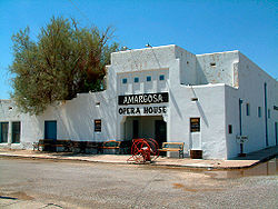 Amargosa Opera House
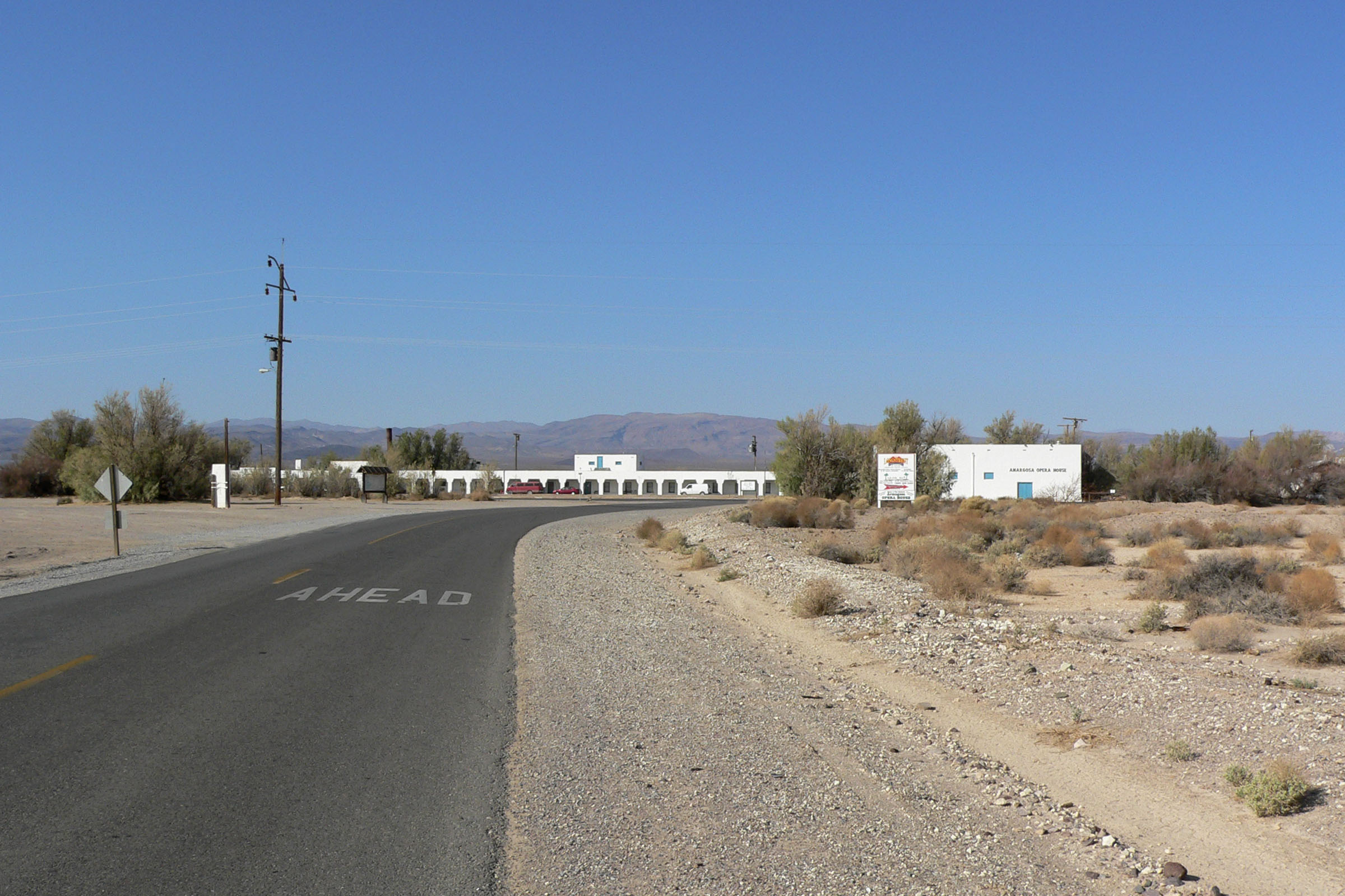
Location: CA 127 and CA 190, Death Valley Junction, California Built: 1923 Architect: Alexander H. McCulloch Architectural style: Mission/Spanish Revival Governing body: Private NRHP Reference#: 80000802[2] Added to NRHP: December 10, 1980 Death Valley Junction (formerly, Amargosa[1] and '"Death Valley'"[3]) is a tiny Mojave Desert community in unincorporated Inyo County, California, at the intersection of SR 190 and SR 127, just east of Death Valley National Park. The zip code is 92328, the elevation is 2,041 ft (622 m), and the population fewer than 20. The city limits sign reports a population of 4. The U.S. Geological Survey lists a historic variant name of Amargosa for the community which is shown as the primary name on an official State of Nevada map from 1971. Its existence and name are official with a USGS feature ID of 1656477. The default format for wired phone numbers in this community is (760) 852-xxxx.
Death Valley Junction is home to the Amargosa Opera House and Hotel, where resident Marta Becket has staged dance and mime shows since the late 1960s. The hotel is operating and the shows continue at the opera house, but beyond these maintained areas, the town is in a state of disrepair. There are no gas stations, and only one restaurant. The single restaurant, T&T Cafe, is part of the Amargosa Opera House and Hotel, but is not run by the hotel staff.
The community's location, 27 miles (43 km) east-southeast of Furnace Creek Inn,[3] on the east side of Death Valley is south of Nevada's Amargosa Valley and near Ash Meadows National Wildlife Refuge. South on SR127 is the town of Shoshone, California. The closest straight-line distance to the Nevada state line is roughly five miles northeast.
Government documents show an effort by the Timbisha Shoshone tribal government to acquire about 7,200 acres (29 km2) in the area during 1999 to 2000. This includes areas for residences and the official federal sanction to use some government lands for traditional ceremonies. It's unclear if these efforts, which were documented in the Congressional Record, succeeded.
Contents
History
In 1914 the Death Valley Railroad started operating between Ryan, CA and Death Valley Junction. It carried borax until 1928, when operations ceased. The name of the town was changed from Amargosa ("bitter water" in a Paiute language) to Death Valley Junction. From 1923 to 1925 the Pacific Coast Borax Company constructed buildings in the town, hiring architect Alexander Hamilton McCulloch to design a Spanish Colonial Revival whistle stop centered at the hotel, theater and office complex building, now known as the Amargosa Opera House and Hotel. The town began to decline in the mid twentieth century, until 1967 when dancer and actress Marta Becket, with help from benefactors, leased, then purchased the hotel and theater complex. The Amargosa is now owned by a non-profit organization.[citation needed]
In 1980 the town was included in the National Register of Historic Places as the "Death Valley Junction Historic District."
The Death Valley post office opened in 1908 and transferred to Furnace Creek Ranch in 1961.[3] The Amargosa post office opened in 1962, changed its name to Death Valley Junction in 1968.[3]
When the Death Valley Railroad was established in 1914, it used 3.19 miles (5.13 km) of tracks belonging to the Tonopah and Tidewater Railroad east-southeast of Death Valley Junction to Horton.[3]
Telephone history
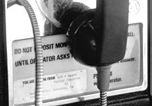 Number detail on instruction card says, "619+Death Valley Junction #2."
Local wired telephones were manual telephone service until the 1980s. To reach a phone in Death Valley Junction when the area was under manual service required dialing the operator and asking for Death Valley Junction, California, Toll Station (and the one-digit number). Placing an outbound call required lifting the receiver and waiting for an operator. The operator who answered was in Los Angeles. The area is now in area code 760.
At right is the bottom instruction card of Death Valley Junction #2, a non-dial Western Electric 1A1 coin collector located at the Amagosa Opera House. Picture was taken in the late 1970s.
Politics
In the state legislature Death Valley Junction is located in the 18th Senate District, represented by Republican Roy Ashburn, and in the 18th Assembly District, represented by Republican Bill Maze. Federally, Death Valley Junction is located in California's 25th congressional district, which has a Cook PVI of R +7[4] and is represented by Republican Buck McKeon.
References
- ^ a b U.S. Geological Survey Geographic Names Information System: Death Valley Junction, California
- ^ "National Register Information System". National Register of Historic Places. National Park Service. 2008-04-15. http://nrhp.focus.nps.gov/natreg/docs/All_Data.html.
- ^ a b c d e Durham, David L. (1998). California's Geographic Names: A Gazetteer of Historic and Modern Names of the State. Quill Driver Books. p. 1159. ISBN 9781884995149.
- ^ "Will Gerrymandered Districts Stem the Wave of Voter Unrest?". Campaign Legal Center Blog. http://www.clcblog.org/blog_item-85.html. Retrieved 2007-10-20.
External links
- The town that Zane Grey helped build
- The Amargosa Opera House and Hotel
- The Amargosa Opera House Museum Fund
- Ghost Towns of Death Valley: Death Valley Junction
Municipalities and communities of Inyo County, California County seat: Independence City 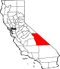
CDPs Big Pine | Cartago | Darwin | Dixon Lane-Meadow Creek | Furnace Creek | Homewood Canyon | Independence | Keeler | Lone Pine | Mesa | Olancha | Pearsonville | Round Valley | Shoshone | Tecopa | Trona | Valley Wells | West Bishop | Wilkerson
Unincorporated
communitiesAberdeen | Alabama Hills | Alico | Alta Vista | Ashford Junction | Aspendell | Badwater | Ballarat | Bartlett | Beatty Junction | Beveridge | Blackrock | Brockmans Corner | Calvada Springs | Coso | Coso Junction | Crater | Death Valley Junction | Deep Springs | Dolomite | Dunmovin | Evelyn | Fish Springs | Grant | Haiwee | Harrisburg | Homewood Canyon-Valley Wells | Indian Village | Junction Ranch | Kearsarge | Keough Hot Springs | Laws | Linnie | Little Lake | Millspaugh | Mock | Monola | Oteys Sierra Village | Owenyo | Panamint Springs | Park Village | Peterson Mill | Poleta | Reward | Rocking K | Rovana | Ryan | Scheelite | Scranton | Seven Pines | Stovepipe Wells | Sykes | Talus | Teakettle Junction | Whitney Portal | Zurich
Indian
reservationsBig Pine Reservation | Lone Pine Reservation
Ghost towns Ashford Mill | Avena | Bend City | Bradford Siding | Burnt Wagons | Carthage | Cerro Gordo Landing | Chloride City | Chrysopolis | Clark | Copperfield | Coso | Echo | Elna | Furnace | Furnace Creek Inn | Greenwater | Grestley | Horton | Intake | Jay | Kasson | Kearsarge | Lane Mill | Leadfield | Lee | Lila C | Lone Pine Station | Lookout City | Manzanar | Narka | Newburyport | Nine Mile Station | Noonday Camp | Owensville | Panamint | Reilly | San Carlos | Schwaub | Skidoo | Skyes | Sodan | Stewarts | Sunland | Swansea | Tule Station | White Mountain City
Death Valley and Death Valley National Park Fauna, flora and minerals Amargosa springsnail · Borax · Chuckwalla · Death Valley monkeyflower · Death Valley pupfish · Death Valley June beetle · Devil's Hole pupfish · Saratoga Springs pupfish
History Amargosa Opera House and Hotel · Badwater · Death Valley Railroad · Greenwater · Harmony Borax Works · Lake Manly (Badwater Basin) · Skidoo · Tonopah and Tidewater Railroad · Twenty-mule team
Places Amargosa Range / River / Valley · Ash Meadows NWR · Badwater Basin · Ballarat · Beatty · Black Mountains · Chloride City · Cottonwood Mountains · Darwin Falls · Death Valley Junction · Eureka Valley / Dunes · Funeral Mountains · Furnace Creek · Panamint City / Range / Springs / Valley · Racetrack · Rhyolite · Saline Valley · Saratoga Springs · Scotty's Castle · Stovepipe Wells · Telescope Peak · Trona · Ubehebe Crater · Zabriskie Point
Transportation U.S. National Register of Historic Places Topics Lists by states Alabama • Alaska • Arizona • Arkansas • California • Colorado • Connecticut • Delaware • Florida • Georgia • Hawaii • Idaho • Illinois • Indiana • Iowa • Kansas • Kentucky • Louisiana • Maine • Maryland • Massachusetts • Michigan • Minnesota • Mississippi • Missouri • Montana • Nebraska • Nevada • New Hampshire • New Jersey • New Mexico • New York • North Carolina • North Dakota • Ohio • Oklahoma • Oregon • Pennsylvania • Rhode Island • South Carolina • South Dakota • Tennessee • Texas • Utah • Vermont • Virginia • Washington • West Virginia • Wisconsin • WyomingLists by territories Lists by associated states Other  Category:National Register of Historic Places •
  Portal:National Register of Historic PlacesCategories:
- Historic districts in California
- National Register of Historic Places in California
- Death Valley
- Amargosa Desert
- Populated places in Inyo County, California
- Populated places in the Mojave Desert
- Unincorporated communities in California


Wikimedia Foundation. 2010.