- Dunmovin, California
-
Dunmovin — Unincorporated community — Location in California
 Dunmovin
Coordinates: 36°05′19″N 117°57′40″W / 36.08861°N 117.96111°WCoordinates: 36°05′19″N 117°57′40″W / 36.08861°N 117.96111°W Country United States State California County Inyo County Elevation[1] 3,507 ft (1,069 m) Dunmovin (formerly, Cowan Station)[2] is an unincorporated community in Inyo County, California.[1] It is located 4.8 km (3 mi) north of Coso Junction and 21.6 km (13.5 mi) south-southeast of Olancha, at an elevation of 3507 feet (1069 m).[1]
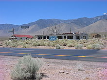 Ruins of Dunmovin
A post office operated at Dunmovin from 1938 to 1941.[2] The place was originally called Cowan Station in honor of homesteader James Cowan.[2] Cowan Station was a freight station for silver ingots being transported from the Cerro Gordo Mines to Los Angeles. When Cowan sold out in 1936, the name was changed to Dunmovin.[2] It was a roadside service station, cafe, and store along U.S. Route 395.
References
Municipalities and communities of Inyo County, California City 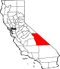
CDPs Big Pine | Cartago | Darwin | Dixon Lane-Meadow Creek | Furnace Creek | Homewood Canyon | Independence | Keeler | Lone Pine | Mesa | Olancha | Pearsonville | Round Valley | Shoshone | Tecopa | Trona | Valley Wells | West Bishop | Wilkerson
Unincorporated
communitiesAberdeen | Alabama Hills | Alico | Alta Vista | Ashford Junction | Aspendell | Badwater | Ballarat | Bartlett | Beatty Junction | Beveridge | Blackrock | Brockmans Corner | Calvada Springs | Coso | Coso Junction | Crater | Death Valley Junction | Deep Springs | Dolomite | Dunmovin | Evelyn | Fish Springs | Grant | Haiwee | Harrisburg | Homewood Canyon-Valley Wells | Indian Village | Junction Ranch | Kearsarge | Keough Hot Springs | Laws | Linnie | Little Lake | Millspaugh | Mock | Monola | Oteys Sierra Village | Owenyo | Panamint Springs | Park Village | Peterson Mill | Poleta | Reward | Rocking K | Rovana | Ryan | Scheelite | Scranton | Seven Pines | Stovepipe Wells | Sykes | Talus | Teakettle Junction | Whitney Portal | Zurich
Indian
reservationsBig Pine Reservation | Lone Pine Reservation
Ghost towns Ashford Mill | Avena | Bend City | Bradford Siding | Burnt Wagons | Carthage | Cerro Gordo Landing | Chloride City | Chrysopolis | Clark | Copperfield | Coso | Echo | Elna | Furnace | Furnace Creek Inn | Greenwater | Grestley | Horton | Intake | Jay | Kasson | Kearsarge | Lane Mill | Leadfield | Lee | Lila C | Lone Pine Station | Lookout City | Manzanar | Narka | Newburyport | Nine Mile Station | Noonday Camp | Owensville | Panamint | Reilly | San Carlos | Schwaub | Skidoo | Skyes | Sodan | Stewarts | Sunland | Swansea | Tule Station | White Mountain City
Categories:- Populated places in Inyo County, California
- Populated places in the Mojave Desert
- Unincorporated communities in California
- Inyo County, California geography stubs


Wikimedia Foundation. 2010.