- Mesa, California
-
Mesa — census-designated place — Location in Inyo County and the state of California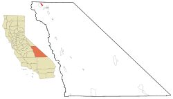
Coordinates: 37°25′18″N 118°32′39″W / 37.42167°N 118.54417°WCoordinates: 37°25′18″N 118°32′39″W / 37.42167°N 118.54417°W Country  United States
State  California
County Inyo Area[1] - Total 3.656 sq mi (9.467 km2) - Land 3.503 sq mi (9.072 km2) - Water 0.153 sq mi (0.395 km2) 4.17% Population (2010) - Total 251 - Density 68.7/sq mi (26.5/km2) Time zone Pacific (PST) (UTC-8) - Summer (DST) PDT (UTC-7) ZIP code 93514 Area code(s) 760 FIPS code 06-47013 Mesa is a census-designated place (CDP) in Inyo County, California, United States. The population was 251 at the 2010 census, up from 214 at the 2000 census.
Contents
Geography
Mesa is located at 37°25′18″N 118°32′39″W / 37.42167°N 118.54417°W (37.421647, -118.544166)[2].
According to the United States Census Bureau, the CDP has a total area of 3.7 square miles (9.6 km2), of which, 3.5 square miles (9.1 km2) of it is land and 0.2 square miles (0.52 km2) of it (4.17%) is water.
Demographics
2010
The 2010 United States Census[3] reported that Mesa had a population of 251. The population density was 68.7 people per square mile (26.5/km²). The racial makeup of Mesa was 220 (87.6%) White, 0 (0.0%) African American, 10 (4.0%) Native American, 3 (1.2%) Asian, 0 (0.0%) Pacific Islander, 14 (5.6%) from other races, and 4 (1.6%) from two or more races. Hispanic or Latino of any race were 26 persons (10.4%).
The Census reported that 251 people (100% of the population) lived in households, 0 (0%) lived in non-institutionalized group quarters, and 0 (0%) were institutionalized.
There were 104 households, out of which 21 (20.2%) had children under the age of 18 living in them, 75 (72.1%) were opposite-sex married couples living together, 2 (1.9%) had a female householder with no husband present, 5 (4.8%) had a male householder with no wife present. There were 5 (4.8%) unmarried opposite-sex partnerships, and 2 (1.9%) same-sex married couples or partnerships. 14 households (13.5%) were made up of individuals and 6 (5.8%) had someone living alone who was 65 years of age or older. The average household size was 2.41. There were 82 families (78.8% of all households); the average family size was 2.62.
The population was spread out with 33 people (13.1%) under the age of 18, 22 people (8.8%) aged 18 to 24, 39 people (15.5%) aged 25 to 44, 117 people (46.6%) aged 45 to 64, and 40 people (15.9%) who were 65 years of age or older. The median age was 50.0 years. For every 100 females there were 97.6 males. For every 100 females age 18 and over, there were 98.2 males.
There were 124 housing units at an average density of 33.9 per square mile (13.1/km²), of which 78 (75.0%) were owner-occupied, and 26 (25.0%) were occupied by renters. The homeowner vacancy rate was 0%; the rental vacancy rate was 0%. 184 people (73.3% of the population) lived in owner-occupied housing units and 67 people (26.7%) lived in rental housing units.
2000
As of the census[4] of 2000, there were 214 people, 85 households, and 64 families residing in the CDP. The population density was 59.9 people per square mile (23.1/km²). There were 91 housing units at an average density of 25.5 per square mile (9.8/km²). The racial makeup of the CDP was 89.25% White, 0.47% Black or African American, 2.80% Native American, 1.87% Asian, 0.47% Pacific Islander, 0.93% from other races, and 4.21% from two or more races. 7.01% of the population were Hispanic or Latino of any race.
There were 85 households out of which 25.9% had children under the age of 18 living with them, 69.4% were married couples living together, 2.4% had a female householder with no husband present, and 24.7% were non-families. 18.8% of all households were made up of individuals and 7.1% had someone living alone who was 65 years of age or older. The average household size was 2.52 and the average family size was 2.86.
In the CDP the population was spread out with 19.2% under the age of 18, 6.1% from 18 to 24, 18.2% from 25 to 44, 41.6% from 45 to 64, and 15.0% who were 65 years of age or older. The median age was 47 years. For every 100 females there were 105.8 males. For every 100 females age 18 and over, there were 101.2 males.
The median income for a household in the CDP was $74,375, and the median income for a family was $76,543. Males had a median income of $51,250 versus $25,357 for females. The per capita income for the CDP was $25,376. About 2.6% of families and 2.4% of the population were below the poverty line, including none of those under the age of eighteen and 6.5% of those sixty five or over.
Politics
In the state legislature Mesa is located in the 18th Senate District, represented by Republican Roy Ashburn, and in the 18th Assembly District, represented by Republican Bill Maze. Federally, Mesa is located in California's 25th congressional district, which has a Cook PVI of R +7[5] and is represented by Republican Buck McKeon.
References
- ^ U.S. Census
- ^ "US Gazetteer files: 2010, 2000, and 1990". United States Census Bureau. 2011-02-12. http://www.census.gov/geo/www/gazetteer/gazette.html. Retrieved 2011-04-23.
- ^ All data are derived from the United States Census Bureau reports from the 2010 United States Census, and are accessible on-line here. The data on unmarried partnerships and same-sex married couples are from the Census report DEC_10_SF1_PCT15. All other housing and population data are from Census report DEC_10_DP_DPDP1. Both reports are viewable online or downloadable in a zip file containing a comma-delimited data file. The area data, from which densities are calculated, are available on-line here. Percentage totals may not add to 100% due to rounding. The Census Bureau defines families as a household containing one or more people related to the householder by birth, opposite-sex marriage, or adoption. People living in group quarters are tabulated by the Census Bureau as neither owners nor renters. For further details, see the text files accompanying the data files containing the Census reports mentioned above.
- ^ "American FactFinder". United States Census Bureau. http://factfinder.census.gov. Retrieved 2008-01-31.
- ^ "Will Gerrymandered Districts Stem the Wave of Voter Unrest?". Campaign Legal Center Blog. http://www.clcblog.org/blog_item-85.html. Retrieved 2007-10-20.
Municipalities and communities of Inyo County, California City 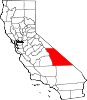
CDPs Big Pine | Cartago | Darwin | Dixon Lane-Meadow Creek | Furnace Creek | Homewood Canyon | Independence | Keeler | Lone Pine | Mesa | Olancha | Pearsonville | Round Valley | Shoshone | Tecopa | Trona | Valley Wells | West Bishop | Wilkerson
Unincorporated
communitiesAberdeen | Alabama Hills | Alico | Alta Vista | Ashford Junction | Aspendell | Badwater | Ballarat | Bartlett | Beatty Junction | Beveridge | Blackrock | Brockmans Corner | Calvada Springs | Coso | Coso Junction | Crater | Death Valley Junction | Deep Springs | Dolomite | Dunmovin | Evelyn | Fish Springs | Grant | Haiwee | Harrisburg | Homewood Canyon-Valley Wells | Indian Village | Junction Ranch | Kearsarge | Keough Hot Springs | Laws | Linnie | Little Lake | Millspaugh | Mock | Monola | Oteys Sierra Village | Owenyo | Panamint Springs | Park Village | Peterson Mill | Poleta | Reward | Rocking K | Rovana | Ryan | Scheelite | Scranton | Seven Pines | Stovepipe Wells | Sykes | Talus | Teakettle Junction | Whitney Portal | Zurich
Indian
reservationsBig Pine Reservation | Lone Pine Reservation
Ghost towns Ashford Mill | Avena | Bend City | Bradford Siding | Burnt Wagons | Carthage | Cerro Gordo Landing | Chloride City | Chrysopolis | Clark | Copperfield | Coso | Echo | Elna | Furnace | Furnace Creek Inn | Greenwater | Grestley | Horton | Intake | Jay | Kasson | Kearsarge | Lane Mill | Leadfield | Lee | Lila C | Lone Pine Station | Lookout City | Manzanar | Narka | Newburyport | Nine Mile Station | Noonday Camp | Owensville | Panamint | Reilly | San Carlos | Schwaub | Skidoo | Skyes | Sodan | Stewarts | Sunland | Swansea | Tule Station | White Mountain City
Categories:- Census-designated places in Inyo County, California


Wikimedia Foundation. 2010.