- Darwin, California
-
Darwin — census-designated place — Location in Inyo County and the state of California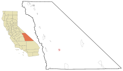
Coordinates: 36°16′05″N 117°35′30″W / 36.26806°N 117.59167°WCoordinates: 36°16′05″N 117°35′30″W / 36.26806°N 117.59167°W Country  United States
State  California
County Inyo Area[1] – Total 1.345 sq mi (3.485 km2) – Land 1.345 sq mi (3.485 km2) – Water 0 sq mi (0 km2) 0% Elevation[2] 4,790 ft (1,460 m) Population (2010) – Total 43 – Density 32/sq mi (12.3/km2) Time zone Pacific (PST) (UTC-8) – Summer (DST) PDT (UTC-7) ZIP code 93522 Area code(s) 760 FIPS code 06-18030 GNIS feature ID 0241269 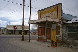 The streets of Darwin
Darwin is a census-designated place (CDP) in Inyo County, California, United States. Darwin is located 22 miles (35 km) southeast of Keeler,[3] at an elevation of 4790 feet (1460 m).[2] The population was 43 at the 2010 census, down from 54 at the 2000 census. It is named after Dr. Darwin French.
Contents
Geography
According to the United States Census Bureau, the CDP has a total area of 1.3 square miles (3.4 km2), all of it land.
History
Silver and lead discovery at the place led to the founding of a settlement in 1875.[3] A post office opened in 1875, closed for a time in 1902, and remains open.[3]
Demographics
2010
The 2010 United States Census[4] reported that Darwin had a population of 43. The population density was 32.0 people per square mile (12.3/km²). The racial makeup of Darwin was 38 (88.4%) White, 0 (0.0%) African American, 2 (4.7%) Native American, 1 (2.3%) Asian, 1 (2.3%) Pacific Islander, 0 (0.0%) from other races, and 1 (2.3%) from two or more races. Hispanic or Latino of any race were 2 persons (4.7%).
The Census reported that 43 people (100% of the population) lived in households, 0 (0%) lived in non-institutionalized group quarters, and 0 (0%) were institutionalized.
There were 28 households, out of which 0 (0%) had children under the age of 18 living in them, 11 (39.3%) were opposite-sex married couples living together, 0 (0%) had a female householder with no husband present, 1 (3.6%) had a male householder with no wife present. There were 1 (3.6%) unmarried opposite-sex partnerships, and 0 (0%) same-sex married couples or partnerships. 14 households (50.0%) were made up of individuals and 9 (32.1%) had someone living alone who was 65 years of age or older. The average household size was 1.54. There were 12 families (42.9% of all households); the average family size was 2.08.
The population was spread out with 0 people (0%) under the age of 18, 0 people (0%) aged 18 to 24, 2 people (4.7%) aged 25 to 44, 20 people (46.5%) aged 45 to 64, and 21 people (48.8%) who were 65 years of age or older. The median age was 63.5 years. For every 100 females there were 168.8 males. For every 100 females age 18 and over, there were 168.8 males.
There were 46 housing units at an average density of 34.2 per square mile (13.2/km²), of which 24 (85.7%) were owner-occupied, and 4 (14.3%) were occupied by renters. The homeowner vacancy rate was 4.0%; the rental vacancy rate was 0%. 37 people (86.0% of the population) lived in owner-occupied housing units and 6 people (14.0%) lived in rental housing units.
2000
As of the census[5] of 2000, there were 54 people, 36 households, and 14 families residing in the CDP. The population density was 39.3 people per square mile (15.1/km²). There were 54 housing units at an average density of 39.3 per square mile (15.1/km²). The racial makeup of the CDP was 90.74% White, 1.85% Black or African American, 3.70% Native American, and 3.70% from two or more races. 5.56% of the population were Hispanic or Latino of any race.
There were 36 households out of which 8.3% had children under the age of 18 living with them, 22.2% were married couples living together, 13.9% had a female householder with no husband present, and 61.1% were non-families. 55.6% of all households were made up of individuals and 8.3% had someone living alone who was 65 years of age or older. The average household size was 1.50 and the average family size was 2.00.
In the CDP the population was spread out with 5.6% under the age of 18, 1.9% from 18 to 24, 16.7% from 25 to 44, 59.3% from 45 to 64, and 16.7% who were 65 years of age or older. The median age was 53 years. For every 100 females there were 145.5 males. For every 100 females age 18 and over, there were 142.9 males.
The median income for a household in the CDP was $13,333, and the median income for a family was $15,000. Males had a median income of under $2500 versus $36,250 for females. The per capita income for the CDP was $11,048. There were 33.3% of families and 37.7% of the population living below the poverty line, including 100.0% of under eighteens and none of those over 64.
Politics
In the state legislature Darwin is located in the 18th Senate District, represented by Republican Jean Fuller, and in the 18th Assembly District, represented by Republican Bill Maze. Federally, Darwin is located in California's 25th congressional district, which has a Cook PVI of R +7[6] and is represented by Republican Buck McKeon.
See also
- Darwin Falls
- Darwin Falls Wilderness
- Darwin Hills
- Darwin, a 2011 documentary film about Darwin, CA
References
- ^ U.S. Census
- ^ a b U.S. Geological Survey Geographic Names Information System: Darwin, California
- ^ a b c Durham, David L. (1998). California's Geographic Names: A Gazetteer of Historic and Modern Names of the State. Quill Driver Books. p. 1158. ISBN 9781884995149.
- ^ All data are derived from the United States Census Bureau reports from the 2010 United States Census, and are accessible on-line here. The data on unmarried partnerships and same-sex married couples are from the Census report DEC_10_SF1_PCT15. All other housing and population data are from Census report DEC_10_DP_DPDP1. Both reports are viewable online or downloadable in a zip file containing a comma-delimited data file. The area data, from which densities are calculated, are available on-line here. Percentage totals may not add to 100% due to rounding. The Census Bureau defines families as a household containing one or more people related to the householder by birth, opposite-sex marriage, or adoption. People living in group quarters are tabulated by the Census Bureau as neither owners nor renters. For further details, see the text files accompanying the data files containing the Census reports mentioned above.
- ^ "American FactFinder". United States Census Bureau. http://factfinder.census.gov. Retrieved 2008-01-31.
- ^ "Will Gerrymandered Districts Stem the Wave of Voter Unrest?". Campaign Legal Center Blog. http://www.clcblog.org/blog_item-85.html. Retrieved 2007-10-20.
Bibliography
References: Palazzo, Robert P. Darwin, California, Lake Grove, OR: Western Places, 1996. The history of the boom and bust of this mining town from 1874-1878.
Robert P. Palazzo. "Post Offices and Postmasters of Inyo County, California 1866-1966", Fernley, NV: MacDonald, 2005.
Municipalities and communities of Inyo County, California City 
CDPs Big Pine | Cartago | Darwin | Dixon Lane-Meadow Creek | Furnace Creek | Homewood Canyon | Independence | Keeler | Lone Pine | Mesa | Olancha | Pearsonville | Round Valley | Shoshone | Tecopa | Trona | Valley Wells | West Bishop | Wilkerson
Unincorporated
communitiesAberdeen | Alabama Hills | Alico | Alta Vista | Ashford Junction | Aspendell | Badwater | Ballarat | Bartlett | Beatty Junction | Beveridge | Blackrock | Brockmans Corner | Calvada Springs | Coso | Coso Junction | Crater | Death Valley Junction | Deep Springs | Dolomite | Dunmovin | Evelyn | Fish Springs | Grant | Haiwee | Harrisburg | Homewood Canyon-Valley Wells | Indian Village | Junction Ranch | Kearsarge | Keough Hot Springs | Laws | Linnie | Little Lake | Millspaugh | Mock | Monola | Oteys Sierra Village | Owenyo | Panamint Springs | Park Village | Peterson Mill | Poleta | Reward | Rocking K | Rovana | Ryan | Scheelite | Scranton | Seven Pines | Stovepipe Wells | Sykes | Talus | Teakettle Junction | Whitney Portal | Zurich
Indian
reservationsBig Pine Reservation | Lone Pine Reservation
Ghost towns Ashford Mill | Avena | Bend City | Bradford Siding | Burnt Wagons | Carthage | Cerro Gordo Landing | Chloride City | Chrysopolis | Clark | Copperfield | Coso | Echo | Elna | Furnace | Furnace Creek Inn | Greenwater | Grestley | Horton | Intake | Jay | Kasson | Kearsarge | Lane Mill | Leadfield | Lee | Lila C | Lone Pine Station | Lookout City | Manzanar | Narka | Newburyport | Nine Mile Station | Noonday Camp | Owensville | Panamint | Reilly | San Carlos | Schwaub | Skidoo | Skyes | Sodan | Stewarts | Sunland | Swansea | Tule Station | White Mountain City
Categories:- Populated places in the Mojave Desert
- Census-designated places in Inyo County, California
- Ghost towns in California
- Populated places established in 1875


Wikimedia Foundation. 2010.