- Placer County, California
-
Coordinates: 39°04′N 120°44′W / 39.06°N 120.73°W
County of Placer — County — 
SealLocation in the state of California California's location in the United States
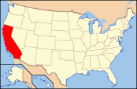
Country  United States
State  California
Regions Sacramento Valley/Sierra Nevada Metro area Greater Sacramento Incorporated 1851 County seat Auburn Largest city Roseville Area – Total 1,503 sq mi (3,892.8 km2) – Land 1,404 sq mi (3,636.3 km2) – Water 98 sq mi (253.8 km2) Population (2010) – Total 348,432 – Density 231.8/sq mi (89.5/km2) Time zone Pacific Standard Time (UTC-8) – Summer (DST) Pacific Daylight Time (UTC-7) Website www.placer.ca.gov Placer County (
 /ˈplæsər/, PLASS-er) is a county located in both the Sacramento Valley and Sierra Nevada regions of the U.S. state of California, in what is known as the Gold Country. It stretches from the suburbs of Sacramento to Lake Tahoe and the Nevada border. Because of the expansion of the Greater Sacramento, Placer County is one of the fastest growing counties in California. Between 2000 and 2010, the population grew from 248,399 to 348,432. The county seat is Auburn.
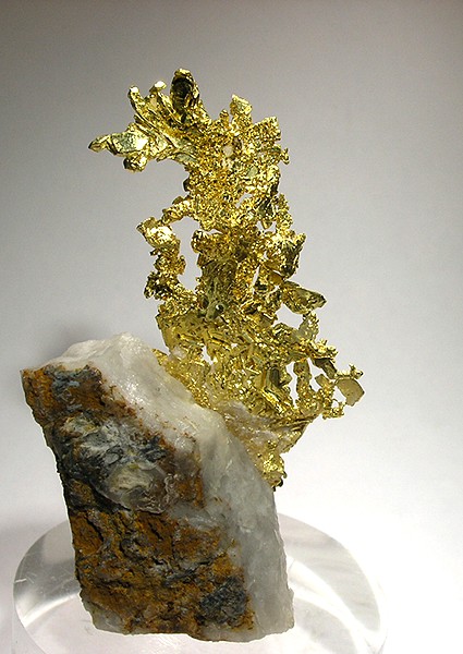
 Gold specimen from the Eagle's Nest Mine, a famous source of specimen gold in Placer County
Contents
History
Placer County was home to the Maidu and Miwok Native Americans for hundreds of years. The discovery of gold in 1848 brought tens of thousands of miners from around the world, in addition to many more thousands intending to provide goods and services to the miners. Only three years after the discovery of gold, the fast-growing county was formed from portions of Sutter and Yuba counties on April 25, 1851 with Auburn as the county seat. Placer County took its name from the Spanish word for sand or gravel deposits containing gold. Miners washed away the gravel, leaving the heavier gold, in a process known as "placer mining."
Gold mining was a major industry through the 1880s, but gradually the new residents turned to farming the fertile foothill soil, harvesting timber and working for the Southern Pacific Railroad. Auburn was settled when Claude Chana discovered gold in Auburn Ravine in May 1848 and later became a shipping and supply center for the surrounding gold camps. The cornerstone of Placer's beautiful and historic courthouse, which is clearly visible from Interstate 80 through Auburn, was laid on July 4, 1894. The building itself was renovated during the late 1980s and continues to serve the public today with courtrooms, a historic sheriff's office and the Placer County Museum. Roseville, once a small agricultural center, became a major railroad center and grew to the county's most populous city after Southern Pacific Railroad moved its railroad switching yards there in 1908.
Loomis and Newcastle began as mining towns, but soon became centers of a booming fruit-growing industry, supporting many local packing houses. Penryn was founded by a Welsh miner, Griffith Griffith, who turned from mining to establish a large granite quarry. Rocklin began as a railroad town and became home to a number of granite quarries. Lincoln and Sheridan continue to support ranching and farming. Lincoln also is the home of one of the county's oldest businesses, the Gladding, McBean terra cotta clay manufacturing plant established in 1875.
In 1960, the 1960 Winter Olympics were hosted in Squaw Valley, which is located in Placer County.
Geography
According to the 2000 census, the county has a total area of 1,502.78 square miles (3,892.2 km2), of which 1,404.37 square miles (3,637.3 km2) (or 93.45%) is land and 98.41 square miles (254.9 km2) (or 6.55%) is water.[1] Watercourses in Placer County include the American River and Bunch Creek. Lake Tahoe has 40.96% of its surface area in Placer County, more than in any of the four other counties in which it lies.[2]
Incorporated cities
Incorporated towns
Unincorporated places
- Alta
- Applegate
- Baxter
- Carnelian Bay
- Dollar Point
- Dutch Flat
- Foresthill
- Granite Bay
- Kings Beach
- Meadow Vista
- Newcastle
- North Auburn
- Ophir
- Penryn
- Olympic Valley
- Sheridan
- Sunnyside-Tahoe City
- Tahoe Vista
- Weimar
Ghost towns
- Iowa Hill
Adjacent counties
- El Dorado County, California - south
- Sacramento County, California - southwest
- Sutter County, California - west
- Yuba County, California - northwest
- Nevada County, California - north
- Washoe County, Nevada - east
- Carson City, Nevada - east
- Douglas County, Nevada - southeast
See also: List of counties bordering eight or more countiesNational protected areas
- El Dorado National Forest in part
- Tahoe National Forest in part
Transportation infrastructure
Major highways
 Interstate 80
 State Route 28
 State Route 49
 State Route 65
 State Route 89
 State Route 174
 State Route 267
Public transportation
- Placer County Transit provides basic bus service primarily along the I-80 corridor between Alta and the Watt Ave. Sacramento Regional Transit light rail station. PCT also runs commuter service to Downtown Sacramento.
- The cities of Auburn, Lincoln, and Roseville have their own local transit service. The city of Roseville also offers a commuter service to Sacramento.
- Gold Country Stage (Nevada County) provides a connection between Auburn and Grass Valley.
- Tahoe Area Regional Transit operates in Truckee (Nevada County), Tahoe City and along the North Shore of Lake Tahoe to Incline Village, Nevada.
- Greyhound and Amtrak provide long distance intercity service.
Airports
There are three general aviation airports in Placer County:
- Lincoln Regional Airport
- Auburn Airport
- Truckee-Tahoe Airport
The closest commercial airport is Sacramento International Airport in Sacramento.
Demographics
2010
The 2010 United States Census reported that Placer County had a population of 348,432. The racial makeup of Placer County was 290,977 (83.5%) White, 4,751 (1.4%) African American, 3,011 (0.9%) Native American, 20,435 (5.9%) Asian, 778 (0.2%) Pacific Islander, 13,375 (3.8%) from other races, and 15,105 (4.3%) from two or more races. Hispanic or Latino of any race were 44,710 persons (12.8%).[3]
Population reported at 2010 United States Census The County Total
PopulationWhite African
AmericanNative
AmericanAsian Pacific
Islanderother
racestwo or
more racesHispanic
or Latino
(of any race)Placer County 348,432 290,977 4,751 3,011 20,435 778 13,375 15,105 44,710 Incorporated
cities and townsTotal
PopulationWhite African
AmericanNative
AmericanAsian Pacific
Islanderother
racestwo or
more racesHispanic
or Latino
(of any race)Auburn 13,330 11,863 100 129 240 9 405 584 1,331 Colfax 1,963 1,759 4 26 29 2 54 89 178 Lincoln 42,819 34,087 629 399 2,663 115 3,125 1,801 7,597 Loomis 6,430 5,733 33 74 169 12 149 260 568 Rocklin 56,974 47,047 858 410 4,105 150 1,538 2,866 6,555 Roseville 118,788 94,199 2,329 885 10,026 346 5,087 5,916 17,359 Census-designated
placesTotal
PopulationWhite African
AmericanNative
AmericanAsian Pacific
Islanderother
racestwo or
more racesHispanic
or Latino
(of any race)Alta 610 592 1 3 5 1 2 6 23 Carnelian Bay 524 493 1 4 14 0 1 11 13 Dollar Point 1,215 1,145 4 6 19 0 24 17 83 Dutch Flat 160 155 0 3 1 0 0 1 4 Foresthill 1,483 1,371 8 29 6 2 17 50 97 Granite Bay 20,402 17,960 148 138 1,152 28 222 754 1,260 Kings Beach 3,796 3,216 15 20 14 2 409 120 2,115 Kingvale‡ 2 2 0 0 0 0 0 0 0 Meadow Vista 3,217 3,017 1 21 35 6 34 103 171 Newcastle 1,224 1,113 7 19 17 0 35 33 104 North Auburn 13,022 11,081 115 172 298 13 893 450 2,108 Penryn 831 718 3 22 32 3 27 26 79 Sheridan 1,238 1,026 7 20 13 3 113 56 253 Sunnyside-Tahoe City 1,557 1,480 3 4 15 1 32 22 84 Tahoe Vista 1,433 1,279 3 8 21 2 82 38 352 Tahoma‡ 411 393 4 3 7 0 1 3 16 Unincorporated
communitiesTotal
PopulationWhite African
AmericanNative
AmericanAsian Pacific
Islanderother
racestwo or
more racesHispanic
or Latino
(of any race)All others not CDPs (combined) 57,003 51,248 478 616 1,554 83 1,125 1,899 4,360 ‡ Note: these numbers reflect only the portion of these CDPs in Placer County 2000
As of the census[4] of 2000, there were 248,399 people, 93,382 households, and 67,701 families residing in the county. The population density was 177 people per square mile (68/km²). There were 107,302 housing units at an average density of 76 per square mile (30/km²). The racial makeup of the county was 88.6% White, 0.8% Black or African American, 0.9% Native American, 3.0% Asian, 0.2% Pacific Islander, 3.4% from other races, and 3.2% from two or more races. 9.7% of the population were Hispanic or Latino of any race. 15.5% were of German, 12.3% English, 10.6% Irish, 7.1% Italian and 7.0% American ancestry according to Census 2000. 89.7% spoke only English at home; 6.0% spoke Spanish.
There were 93,382 households out of which 35.3% had children under the age of 18 living with them, 59.4% were married couples living together, 9.2% had a female householder with no husband present, and 27.5% were non-families. 21.3% of all households were made up of individuals and 8.1% had someone living alone who was 65 years of age or older. The average household size was 2.63 and the average family size was 3.06.
In the county the population was spread out with 26.5% under the age of 18, 6.9% from 18 to 24, 29.00% from 25 to 44, 24.5% from 45 to 64, and 13.1% who were 65 years of age or older. The median age was 38 years. For every 100 females there were 96.40 males. For every 100 females age 18 and over, there were 93.90 males.
The median income for a household in the county was $57,535, and the median income for a family was $65,858 (these figures had risen to $68,463 and $80,987 respectively as of a 2007 estimate[5]). Males had a median income of $50,410 versus $33,763 for females. The per capita income for the county was $27,963. About 3.9% of families and 5.8% of the population were below the poverty line, including 6.3% of those under age 18 and 3.8% of those age 65 or over.
Politics
Presidential Election Results Year GOP DEM Others 2008 54.5% 80,209 43.8% 64,460 1.7% 2,465 2004 62.6% 95,969 36.3% 55,573 1.1% 1,736 2000 59.3% 69,835 36.0% 42,449 4.7% 5,515 1996 52.8% 49,808 37.1% 34,981 10.2% 9,638 1992 41.9% 38,298 33.7% 30,783 24.4% 22,285 1988 59.6% 42,096 39.0% 27,516 1.5% 1,030 1984 62.9% 38,035 35.2% 21,294 1.8% 1,098 1980 54.8% 28,179 33.7% 17,311 11.6% 5,950 1976 45.0% 18,154 52.2% 21,026 2.8% 1,131 1972 50.3% 18,597 45.8% 16,911 3.9% 1,437 1968 42.6% 12,427 48.2% 14,050 9.2% 2,667 1964 33.9% 9,389 66.0% 18,256 0.1% 31 1960 43.8% 10,439 55.8% 13,304 0.5% 120 Placer County is a stronghold of the Republican Party; it consistently elects Republican public officials and has voted for presidential candidates from the party in every election since 1980.
Placer is part of California's 4th congressional district, which is held by Republican Tom McClintock. McClintock does not reside in the district, but in the 3rd congressional district, Elk Grove. While running for that office, his legal residence for his state senate seat was Thousand Oaks in Southern California. In the State Assembly, Placer is part of the 3rd, 4th, and 5th districts, which are held by Republican Dan Logue, Republican Beth Gaines and Democrat Richard Pan respectively. In the State Senate, Placer is mostly in the 1st district with parts in the 4th district. Both districts are held by Republicans, Ted Gaines and Doug LaMalfa respectively.
In 2004, current and former Placer County social workers reported that the county had an "unwritten policy" of homeless dumping, encouraging employees to send homeless individuals to neighboring jurisdictions—namely facilities in Sacramento County. The story was initially reported in the Sacramento News & Review and corroborated in an independent story in the Sacramento Bee.[6][7] Based on this and other instances of homeless dumping in Sacramento, California State Assembly Member Dave Jones introduced Assembly Bill 2745, prohibiting hospitals from sending a homeless person to a facility in another county without that facility's consent.[8] The bill became law in 2006 when it was signed by Governor Schwarzenegger and included in Section 1262.4 of the California Health and Safety Code.[9][10]
Economy
Top employers
According to the County's 2010 Comprehensive Annual Financial Report,[11] the top employers in the county are:
# Employer # of Employees 1 Kaiser Permanente 3,064 2 Hewlett-Packard 2,500 3 Placer County 2,400 4 Union Pacific Railroad 2,000 5 Sutter Health 1,983 6 Northstar at Tahoe 1,500 7 Thunder Valley Casino Resort 1,412 8 City of Roseville 1,282 9 PRIDE Industries 1,135 10 Raley's Supermarkets 1,006 See also
- Hiking trails in Placer County
- List of school districts in Placer County, California
- National Register of Historic Places listings in Placer County, California
References
- ^ "Census 2000 U.S. Gazetteer Files: Counties". United States Census. http://www.census.gov/tiger/tms/gazetteer/county2k.txt. Retrieved 2011-02-13.
- ^ Lake Tahoe census tract blocks, 2000 Census, United States Census Bureau
- ^ "2010 Census P.L. 94-171 Summary File Data". United States Census Bureau. http://www2.census.gov/census_2010/01-Redistricting_File--PL_94-171/California/.
- ^ "American FactFinder". United States Census Bureau. http://factfinder.census.gov. Retrieved 2008-01-31.
- ^ "Placer County, California - Fact Sheet - American FactFinder". Factfinder.census.gov. http://factfinder.census.gov/servlet/ACSSAFFFacts?_event=Search&geo_id=05000US06059&_geoContext=01000US%7C04000US06%7C05000US06059&_street=&_county=placer&_cityTown=placer&_state=04000US06&_zip=&_lang=en&_sse=on&ActiveGeoDiv=geoSelect&_useEV=&pctxt=fph&pgsl=050&_submenuId=factsheet_1&ds_name=ACS_2007_3YR_SAFF&_ci_nbr=null&qr_name=null®=null%3Anull&_keyword=&_industry=. Retrieved 2010-07-22.
- ^ Duman, Jill (2004-02-14). "Exporting indigence: Social worker calls recent homeless-dumping the 'tip of the iceberg'". Sacramento News & Review (Chico Community Publishing, Inc.). http://www.newsreview.com/sacramento/Content?oid=27474. Retrieved 2008-07-14.
- ^ Wiener, Jocelyn (2004-02-22). "Is Placer dumping homeless? With no emergency shelter of its own, county sends its clients to Sacramento, social workers say". Sacramento Bee (The McClatchy Company). Archived from the original on 2008-05-15. http://web.archive.org/web/20080515194720/http://dwb.sacbee.com/content/news/story/8319787p-9250150c.html. Retrieved 2008-07-14.
- ^ "Castoff practice banned by bills: Shipping homeless across county lines draws legislators' ire" (fee required). Sacramento Bee (The McClatchy Company): p. B1. May 5, 2006. Article 1. http://www.sacbee.com/static/live/search. Retrieved 2008-07-14.
- ^ "AB 2745 Assembly Bill - Chaptered". Legislative Counsel, State of California. http://leginfo.ca.gov/pub/05-06/bill/asm/ab_2701-2750/ab_2745_bill_20060929_chaptered.html. Retrieved 2008-07-14.
- ^ "California Health and Safety Code Division 2, Chapter 2, Article 1.". Legislative Counsel, State of California. http://leginfo.ca.gov/cgi-bin/displaycode?section=hsc&group=01001-02000&file=1250-1264. Retrieved 2008-07-14.
- ^ County of Placer CAFR
External links
- Official Placer County website
- Placer County Seat Information
- Placer County Library
- Placer Nature Center
- Placer County Museums
- Placer Sentinel Newspaper
- [1] Special Election called for 4th Assembly District, 1/11/2011

Wikimedia Commons has media related to: 
Yuba County Nevada County Sutter County 
Washoe County, Nevada and Carson City, Nevada  Placer County, California

Sacramento County El Dorado County Douglas County, Nevada Municipalities and communities of Placer County, California Cities and towns 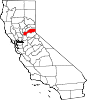
CDPs Alta | Carnelian Bay | Dollar Point | Dutch Flat | Foresthill | Granite Bay | Kings Beach | Kingvale‡ | Meadow Vista | Newcastle | North Auburn | Penryn | Sheridan | Sunnyside-Tahoe City | Tahoe Vista | Tahoma‡
Unincorporated
communitiesAlpine Meadows | Applegate | Baxter | Big Bend | Blue Canyon | Brockway | Cape Horn | Casa Loma | Chambers Lodge | Cisco | Cisco Grove | Clayton | Clipper Gap | Donner | Eder | Elders Corner | Emigrant Gap | Forebay | Four Acres | Gold Hill | Greekstore | Heather Glen | Hidden Valley | Homewood | Hughes Mill | Idlewild | Iowa Hill | Kilaga Springs | Lake Forest | Lander Crossing | Last Chance | Magra | McCulloh | Michigan Bluff | Midas | Monte Vista | Nielsburg | Ophir | Pinecroft | Rainbow | Rampart | Ramsey Crossing | Rawhide | Secret Town | Soda Springs | Squaw Valley | Sunnyside | Tahoe City | Tahoe Pines | The Cedars | Todd Valley | Towle | Troy | Virginiatown | Westville | Weimar | Whitney | Yankee Jims | Zuver
Ghost
townsAckerman | Andover | Arctic | Baltimore | Bath | Blue Bluffs | Bullion | Cairns | Ceres Flat | Chicago Park | Coon Creek | Deadwood | Drum | East Auburn | Flat Ravine | Florence Spring | Fort Trojan | Frytown | Fulda | Gilsons Station | Goggins | Gold Run | Indiana Hill | Knapp | Kulkumish | Leta | Little Rattlesnake Bar | Lone Star | Lost Camp | Mayflower | Millertown | Mineral Bar | Molma | Moss Hills | Oilville | Pine Grove | Pitsokut | Ralston | Red Point | Secret Canyon | Secret Ravine | Smiths | Spruce | Stanford | Stewarts Flat | Stonehill | Tamarack | Union Shed | Vantrent | Webster | Yorkville
Footnotes ‡This CDP also has portions in an adjacent county or counties
Greater Sacramento Counties Douglas (NV) · El Dorado · Nevada · Placer · Sacramento · Sutter · Yolo · Yuba
Major City Cities
and
towns100k–200k25k–100kArden Arcade · Auburn · Carmichael · Citrus Heights · Davis · Folsom · Florin · Laguna · Lincoln · North Highlands · Orangevale · Parkway-South Sacramento · Rancho Cordova · Rocklin · West Sacramento · Woodland · Yuba City
10k–25kCameron Park · El Dorado Hills · Fair Oaks · Foothill Farms · Galt · Gardnerville Ranchos (NV) · Granite Bay · Grass Valley · La Riviera · Linda · Marysville · North Auburn · Olivehurst · Placerville · Rosemont · Rio Linda · South Lake Tahoe · South Yuba City · Truckee · Vineyard
Sub-regions Gold Country · Lake Tahoe · Sacramento Valley · Sierra Nevada · Yuba-Sutter Area
Categories:- California counties
- Placer County, California
- Sacramento metropolitan area


Wikimedia Foundation. 2010.