- North Auburn, California
-
North Auburn — census-designated place — Location in Placer County and the state of California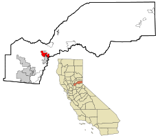
Coordinates: 38°56′2″N 121°5′2″W / 38.93389°N 121.08389°WCoordinates: 38°56′2″N 121°5′2″W / 38.93389°N 121.08389°W Country  United States
State  California
County Placer Government – N/A – State Senate Dave Cox (R) – State Assembly Ted Gaines (R) – U. S. Congress Tom McClintock (R) Area[1] – Total 7.801 sq mi (20.205 km2) – Land 7.798 sq mi (20.198 km2) – Water 0.003 sq mi (0.007 km2) 0.04% Elevation 1,470 ft (448 m) Population (2000) – Total 11,847 – Density 1,558.8/sq mi (598.3/km2) Time zone PST (UTC-8) – Summer (DST) PDT (UTC-7) ZIP code 95603 Area code(s) 530 FIPS code 06-51637 GNIS feature ID 1867045 North Auburn is a census-designated place (CDP) in Placer County, California, United States. It is part of the Sacramento–Arden-Arcade–Roseville Metropolitan Statistical Area. The population was 13,022 at the 2010 census, up from 11,847 at the 2000 census.
Contents
Geography
North Auburn is located at 38°56′2″N 121°5′2″W / 38.93389°N 121.08389°W (38.933881, -121.083769).[2]
According to the United States Census Bureau, the CDP has a total area of 7.8 square miles (20 km2), 99.96% of it land and 0.04% of it water.
Demographics
2010
The 2010 United States Census[3] reported that North Auburn had a population of 13,022. The population density was 1,669.3 people per square mile (644.5/km²). The racial makeup of North Auburn was 11,081 (85.1%) White, 115 (0.9%) African American, 172 (1.3%) Native American, 298 (2.3%) Asian, 13 (0.1%) Pacific Islander, 893 (6.9%) from other races, and 450 (3.5%) from two or more races. Hispanic or Latino of any race were 2,108 persons (16.2%).
The Census reported that 11,999 people (92.1% of the population) lived in households, 308 (2.4%) lived in non-institutionalized group quarters, and 715 (5.5%) were institutionalized.
There were 5,080 households, out of which 1,440 (28.3%) had children under the age of 18 living in them, 2,254 (44.4%) were opposite-sex married couples living together, 598 (11.8%) had a female householder with no husband present, 238 (4.7%) had a male householder with no wife present. There were 312 (6.1%) unmarried opposite-sex partnerships, and 24 (0.5%) same-sex married couples or partnerships. 1,657 households (32.6%) were made up of individuals and 978 (19.3%) had someone living alone who was 65 years of age or older. The average household size was 2.36. There were 3,090 families (60.8% of all households); the average family size was 2.97.
The population was spread out with 2,732 people (21.0%) under the age of 18, 1,125 people (8.6%) aged 18 to 24, 2,988 people (22.9%) aged 25 to 44, 3,535 people (27.1%) aged 45 to 64, and 2,642 people (20.3%) who were 65 years of age or older. The median age was 42.5 years. For every 100 females there were 93.2 males. For every 100 females age 18 and over, there were 92.7 males.
There were 5,539 housing units at an average density of 710.0 per square mile (274.1/km²), of which 3,092 (60.9%) were owner-occupied, and 1,988 (39.1%) were occupied by renters. The homeowner vacancy rate was 2.9%; the rental vacancy rate was 10.1%. 6,869 people (52.7% of the population) lived in owner-occupied housing units and 5,130 people (39.4%) lived in rental housing units.
2000
As of the census[4] of 2000, there were 11,847 people, 4,817 households, and 2,991 families residing in the CDP. The population density was 1,553.2 people per square mile (599.5/km²). There were 4,982 housing units at an average density of 653.2 per square mile (252.1/km²). The racial makeup of the CDP was 89.74% White, 0.71% African American, 1.17% Native American, 1.79% Asian, 0.09% Pacific Islander, 3.73% from other races, and 2.76% from two or more races. Hispanic or Latino of any race were 9.21% of the population.
There were 4,817 households out of which 28.0% had children under the age of 18 living with them, 45.3% were married couples living together, 12.7% had a female householder with no husband present, and 37.9% were non-families. 31.7% of all households were made up of individuals and 17.9% had someone living alone who was 65 years of age or older. The average household size was 2.32 and the average family size was 2.90.
In the CDP the population was spread out with 22.3% under the age of 18, 8.1% from 18 to 24, 25.7% from 25 to 44, 22.5% from 45 to 64, and 21.4% who were 65 years of age or older. The median age was 41 years. For every 100 females there were 90.4 males. For every 100 females age 18 and over, there were 86.9 males.
The median income for a household in the CDP was $37,493, and the median income for a family was $46,418. Males had a median income of $37,673 versus $26,789 for females. The per capita income for the CDP was $22,091. About 7.0% of families and 9.4% of the population were below the poverty line, including 14.7% of those under age 18 and 3.0% of those age 65 or over.
References
- ^ U.S. Census
- ^ "US Gazetteer files: 2010, 2000, and 1990". United States Census Bureau. 2011-02-12. http://www.census.gov/geo/www/gazetteer/gazette.html. Retrieved 2011-04-23.
- ^ All data are derived from the United States Census Bureau reports from the 2010 United States Census, and are accessible on-line here. The data on unmarried partnerships and same-sex married couples are from the Census report DEC_10_SF1_PCT15. All other housing and population data are from Census report DEC_10_DP_DPDP1. Both reports are viewable online or downloadable in a zip file containing a comma-delimited data file. The area data, from which densities are calculated, are available on-line here. Percentage totals may not add to 100% due to rounding. The Census Bureau defines families as a household containing one or more people related to the householder by birth, opposite-sex marriage, or adoption. People living in group quarters are tabulated by the Census Bureau as neither owners nor renters. For further details, see the text files accompanying the data files containing the Census reports mentioned above.
- ^ "American FactFinder". United States Census Bureau. http://factfinder.census.gov. Retrieved 2008-01-31.
External links

Sheridan Alta Sierra Foresthill Rio Oso 
Georgetown  North Auburn

Lincoln Auburn Cool Municipalities and communities of Placer County, California Cities and towns 
CDPs Alta | Carnelian Bay | Dollar Point | Dutch Flat | Foresthill | Granite Bay | Kings Beach | Kingvale‡ | Meadow Vista | Newcastle | North Auburn | Penryn | Sheridan | Sunnyside-Tahoe City | Tahoe Vista | Tahoma‡
Unincorporated
communitiesAlpine Meadows | Applegate | Baxter | Big Bend | Blue Canyon | Brockway | Cape Horn | Casa Loma | Chambers Lodge | Cisco | Cisco Grove | Clayton | Clipper Gap | Donner | Eder | Elders Corner | Emigrant Gap | Forebay | Four Acres | Gold Hill | Greekstore | Heather Glen | Hidden Valley | Homewood | Hughes Mill | Idlewild | Iowa Hill | Kilaga Springs | Lake Forest | Lander Crossing | Last Chance | Magra | McCulloh | Michigan Bluff | Midas | Monte Vista | Nielsburg | Ophir | Pinecroft | Rainbow | Rampart | Ramsey Crossing | Rawhide | Secret Town | Soda Springs | Squaw Valley | Sunnyside | Tahoe City | Tahoe Pines | The Cedars | Todd Valley | Towle | Troy | Virginiatown | Westville | Weimar | Whitney | Yankee Jims | Zuver
Ghost
townsAckerman | Andover | Arctic | Baltimore | Bath | Blue Bluffs | Bullion | Cairns | Ceres Flat | Chicago Park | Coon Creek | Deadwood | Drum | East Auburn | Flat Ravine | Florence Spring | Fort Trojan | Frytown | Fulda | Gilsons Station | Goggins | Gold Run | Indiana Hill | Knapp | Kulkumish | Leta | Little Rattlesnake Bar | Lone Star | Lost Camp | Mayflower | Millertown | Mineral Bar | Molma | Moss Hills | Oilville | Pine Grove | Pitsokut | Ralston | Red Point | Secret Canyon | Secret Ravine | Smiths | Spruce | Stanford | Stewarts Flat | Stonehill | Tamarack | Union Shed | Vantrent | Webster | Yorkville
Footnotes ‡This CDP also has portions in an adjacent county or counties
Greater Sacramento Counties Douglas (NV) · El Dorado · Nevada · Placer · Sacramento · Sutter · Yolo · Yuba
Major City Cities
and
towns100k–200k25k–100kArden Arcade · Auburn · Carmichael · Citrus Heights · Davis · Folsom · Florin · Laguna · Lincoln · North Highlands · Orangevale · Parkway-South Sacramento · Rancho Cordova · Rocklin · West Sacramento · Woodland · Yuba City
10k–25kCameron Park · El Dorado Hills · Fair Oaks · Foothill Farms · Galt · Gardnerville Ranchos (NV) · Granite Bay · Grass Valley · La Riviera · Linda · Marysville · North Auburn · Olivehurst · Placerville · Rosemont · Rio Linda · South Lake Tahoe · South Yuba City · Truckee · Vineyard
Sub-regions Gold Country · Lake Tahoe · Sacramento Valley · Sierra Nevada · Yuba-Sutter Area
Categories:- Census-designated places in Placer County, California
- Sacramento metropolitan area


Wikimedia Foundation. 2010.