- San Benito County, California
-
For the California wine region, see San Benito AVA.
County of San Benito — County — 
SealLocation in the state of California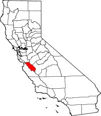 California's location in the United States
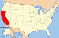
Country  United States
State  California
Region Central California, San Francisco Bay Area Combined Statistical Area Incorporated 1874 County seat Hollister Area – Total 3,602 km2 (1,390.73 sq mi) – Land 3,597.6 km2 (1,389.06 sq mi) – Water 4.4 km2 (1.68 sq mi) Population (2010) 55,269 Time zone Pacific Standard Time (UTC-8) – Summer (DST) Pacific Daylight Time (UTC-7) Website www.san-benito.ca.us San Benito County is a county located in the Coast Range Mountains of the U.S. state of California, south of San Jose. As of 2010 the population was 55,269. The county seat is Hollister, which includes nearly two-thirds of the county's population. El Camino Real passes through the county and includes one mission in San Juan Bautista.
San Benito is included in the U.S. government's 11-county designation of the San Francisco Bay Area Combined Statistical Area.
Contents
History
San Benito County was formed from parts of Monterey County in 1874.
The county is named after the San Benito Valley. Father Juan Crespí, in his expedition in 1772, named a small river in honor of San Benedicto (Saint Benedict), the patron saint of the married, and it is from the contraction of this name that the county took its name.
Geography
According to the 2000 census, the county has a total area of 1,390.73 square miles (3,602.0 km2), of which 1,389.06 square miles (3,597.6 km2) (or 99.88%) is land and 1.68 square miles (4.4 km2) (or 0.12%) is water.[1]
Sharing a border with Santa Clara County, San Benito County lies adjacent to the San Francisco Bay Area and is sometimes considered a part of that region. Frequently, the county is associated with the Monterey Bay Area through governmental organizations such as the Association of Monterey Bay Area Governments as well as the Pajaro River, which flows from northern San Benito County into the Monterey Bay. However, the United States Census Bureau includes the county in the San Jose-Sunnyvale-Santa Clara MSA and the San Jose-San Francisco-Oakland CSA, which the Census uses as a statistical definition of the San Francisco Bay Area.
The county is also the location of the Mount Harlan and San Benito American Viticultural Areas. The latter contains the Cienega Valley, Lime Kiln Valley, and Paicines AVAs.
Fauna and flora
There are a number of plant communities that occur in San Benito County including grasslands and chaparral; however, one of the more unusual is the Sargent cypress forest.[2] Benitoite, the official gem of the State of California, was discovered in San Benito County.[3] The county is also home to the San Benito evening primrose (Camissonia benitensis);[4] and Illacme plenipes, a millipede having more legs than any other millipede species, discovered in the county in 1926.[5] The plant genus Benitoa was named for San Benito County.[6]
Incorporated Cities
Unincorporated Towns
- Aromas
- Paicines
- Tres Pinos
- New Idria (abandoned)
Adjacent counties
- Santa Clara County — north/northwest
- Merced County — northeast
- Fresno County — east/southeast
- Monterey County — southwest/west
- Santa Cruz County — northwest
National protected area
Transportation Infrastructure
Major highways
Public transportation
San Benito County Express provides fixed route service in the city of Hollister, and intercity service in the northern portion of the county. Service operates as far north as Gilroy, in Santa Clara County.
Airports
Hollister Municipal Airport is a general aviation airport located just north of Hollister.
Demographics
Historical populations Census Pop. %± 1880 5,584 — 1890 6,412 14.8% 1900 6,633 3.4% 1910 8,041 21.2% 1920 8,995 11.9% 1930 11,311 25.7% 1940 11,392 0.7% 1950 14,370 26.1% 1960 15,396 7.1% 1970 18,226 18.4% 1980 25,005 37.2% 1990 36,697 46.8% 2000 53,234 45.1% 2010 55,269 3.8% 2010
The 2010 United States Census reported that San Benito County had a population of 55,269. The racial makeup of San Benito County was 35,181 (63.7%) White, 483 (0.9%) African American, 895 (1.6%) Native American, 1,443 (2.6%) Asian, 94 (0.2%) Pacific Islander, 14,471 (26.2%) from other races, and 2,702 (4.9%) from two or more races. Hispanic or Latino of any race were 31,186 persons (56.4%).[7]
Population reported at 2010 United States Census The County Total
PopulationWhite African
AmericanNative
AmericanAsian Pacific
Islanderother
racestwo or
more racesHispanic
or Latino
(of any race)San Benito County 55,269 35,181 483 895 1443 94 14,471 2,702 31,186 Incorporated
citiesTotal
PopulationWhite African
AmericanNative
AmericanAsian Pacific
Islanderother
racestwo or
more racesHispanic
or Latino
(of any race)Hollister 34,928 20,761 341 617 929 63 10,437 1,780 22,965 San Juan Bautista 1,862 1,125 12 58 52 2 494 119 907 Census-designated
placesTotal
PopulationWhite African
AmericanNative
AmericanAsian Pacific
Islanderother
racestwo or
more racesHispanic
or Latino
(of any race)Aromas ‡ 1,292 961 9 13 14 3 207 85 413 Ridgemark 3,016 2,520 23 14 105 3 248 103 623 Tres Pinos 476 390 3 8 6 0 57 12 112 Unincorporated
communitiesTotal
PopulationWhite African
AmericanNative
AmericanAsian Pacific
Islanderother
racestwo or
more racesHispanic
or Latino
(of any race)All others not CDPs (combined) 13,695 9,424 95 185 337 23 3,028 603 6,166 ‡ Note: these numbers reflect only the portion of this CDP in San Benito County 2000
As of the census[8] of 2000, there were 53,234 people, 15,885 households, and 12,898 families residing in the county. The population density was 38 people per square mile (15/km²). There were 16,499 housing units at an average density of 12 per square mile (5/km²). The racial makeup of the county in 2010 was 38.3% non-Hispanic White, 0.6% non-Hispanic Black or African American, 0.4% Native American, 2.3% Asian, 0.1% Pacific Islander, 0.1% from other races, and 1.7% from two or more races. 56.4% of the population were Hispanic or Latino of any race. 7.6% were of German, 6.3% Irish and 5.4% Italian ancestry according to Census 2000. 62.8% spoke English and 35.3% Spanish as their first language. As of the 2010 United States Census, San Benito County was the only county in the greater San Francisco Bay Area with a Hispanic majority and where a minority race formed the largest race composition.
There were 15,885 households out of which 46.3% had children under the age of 18 living with them, 65.7% were married couples living together, 10.5% had a female householder with no husband present, and 18.8% were non-families. 14.1% of all households were made up of individuals and 5.4% had someone living alone who was 65 years of age or older. The average household size was 3.32 and the average family size was 3.64.
In the county the population was spread out with 32.2% under the age of 18, 8.8% from 18 to 24, 31.5% from 25 to 44, 19.3% from 45 to 64, and 8.1% who were 65 years of age or older. The median age was 31 years. For every 100 females there were 102.5 males. For every 100 females age 18 and over, there were 99.6 males.
The median income for a household in the county was $57,469, and the median income for a family was $60,665. Males had a median income of $44,158 versus $29,524 for females. The per capita income for the county was $20,932. About 6.7% of families and 10.0% of the population were below the poverty line, including 11.4% of those under age 18 and 8.5% of those age 65 or over.
Politics
San Benito County vote
by party in presidential electionsYear GOP DEM Others 2008 37.7% 7,425 60.5% 11,917 2.3% 446 2004 46.5% 8,698 52.6% 9,851 0.9% 176 2000 41.7% 7,015 54.3% 9,131 4.1% 685 1996 38.7% 5,384 50.6% 7,030 10.7% 1,492 1992 32.3% 4,112 42.0% 5,354 25.7% 3,273 1988 54.1% 5,578 44.2% 4,559 1.7% 171 1984 60.7% 5,695 37.9% 3,554 1.4% 131 1980 53.3% 4,054 36.2% 2,749 10.5% 799 1976 50.9% 3,398 46.7% 3,122 2.4% 160 1972 57.6% 3,961 37.5% 2,582 4.9% 338 1968 47.5% 2,961 45.1% 2,809 7.4% 459 1964 39.2% 2,444 60.6% 3,779 0.2% 14 1960 51.4% 3,056 48.4% 2,876 0.2% 13 1956 59.5% 3,252 40.3% 2,201 0.2% 10 1952 65.2% 3,733 34.4% 1,968 0.4% 22 1948 55.6% 2,775 42.0% 2,096 2.3% 116 1944 52.8% 2,253 46.8% 1,998 0.4% 16 1940 49.3% 2,407 50.0% 2,441 0.7% 35 1936 36.6% 1,515 61.9% 2,565 1.5% 62 1932 33.9% 1,269 61.0% 2,283 5.1% 192 1928 58.9% 1,971 40.8% 1,366 0.3% 11 1924 53.5% 1,443 13.4% 361 33.1% 891 1920 65.0% 1,965 29.8% 900 5.2% 158 San Benito is a Democratic-leaning county in Presidential and congressional elections. The last Republican to win a majority in the county was George H.W. Bush in 1988. It is often considered the bellwether of California, as most of its election returns mirrored the state as a whole. San Benito is part of California's 17th congressional district, which is held by Democrat Sam Farr. In the state legislature San Benito is in the 28th Assembly district, which is held by Democrat Luis Alejo, and the 12th Senate district, which is held by Republican Anthony Cannella.
County government is overseen by a five-member elected Board of Supervisors, who serve four year terms of office. Other elected county leaders include:
- Assessor
- Clerk-Auditor-Recorder
- District Attorney
- Marshal
- Sheriff-Coroner
- Treasurer-Tax Collector-Public Administrator
San Benito County has the last elected Marshal in California. Shasta and Trinity Counties still have appointed Marshals.
As of May, 2010, the California Secretary of State reports that San Benito County has 34,562 eligible voters. Of those 24,736 (71.57%) are registered voters. Of those, 11,959 (48.35%) are registered Democratic, 7,477 (30.23%) are registered Republican, 565 (2.28%)are registered American Independent, and 116 (0.47%) are Green Party. The two incorporated municipalities of Hollister and San Juan Bautista have Democratic majorities on their voter rolls, whereas the unincorporated areas of San Benito County have a small Republican plurality in voter registration.
Economy
Top employers
According to the San Benito County Chamber of Commerce,[9] the top employers in the county are:
# Employer # of employees 1 Earthbound Farm 1000+ 2 Hazel Hawkins Memorial Hospital 250-499 3 Milgard 250-499 4 Pacific Scientific 250-499 5 San Benito High School 250-499 6 True Leaf Farms 250-499 7 Nob Hill Foods 100-249 8 Target 100-249 9 Trical 100-249 10 Corbin 100-249 11 West Marine 100-249 12 Ridgemark 100-249 13 Casa de Fruita 100-249 14 Cedar Valley Shingle Systems 100-249 15 Tanimura & Antle 100-249 16 El Modeno Gardens[10]100-249 17 LifeSparc 100-249 18 MC Electronics 100-249 19 San Benito Foods 100-249 See also
- National Register of Historic Places listings in San Benito County, California
- George H. Moore, San Benito County district attorney
References
- ^ "Census 2000 U.S. Gazetteer Files: Counties". United States Census. http://www.census.gov/tiger/tms/gazetteer/county2k.txt. Retrieved 2011-02-13.
- ^ C. Michael Hogan. 2010. Leather Oak, Quercus durata. Encyclopedia of Earth. National Council for Science and Environment. Wash.DC
- ^ Louderback, George Davis. 1907. "Benitoite, A New California Gem Mineral." Bulletin of The Department of Geology, Vol. 5, No. 9. University of California Publications.
- ^ Hickman, James C. (editor). 1993. The Jepson Manual: Higher Plants of California. University of California Press.
- ^ Sara Goudarzi (June 7, 2006). "666-Legged Creature Rediscovered.". LiveScience. http://www.livescience.com/animals/060607_leggy_millipede.html.
- ^ Flora of North America: Benitoa
- ^ "2010 Census P.L. 94-171 Summary File Data". United States Census Bureau. http://www2.census.gov/census_2010/01-Redistricting_File--PL_94-171/California/.
- ^ "American FactFinder". United States Census Bureau. http://factfinder.census.gov. Retrieved 2008-01-31.
- ^ San Benito County Chamber of Commerce-Economic Development
- ^ Color Spot Buys El Modeno Assets. Greenhouse Grower.
External links

Santa Cruz County Santa Clara County Merced County Monterey County 
Fresno County  San Benito County, California

Monterey County Monterey County Fresno County Municipalities and communities of San Benito County, California Cities 
CDPs Aromas‡ | Ridgemark | Tres Pinos
Unincorporated
communitiesGhost
townFootnotes ‡This populated place also has portions in an adjacent county or counties
California Central Coast Counties 
Cities and towns
100k-250kCities and towns
25k-100kAtascadero • Goleta • Hollister • Lompoc • Marina • Monterey • Orcutt • Paso Robles • San Luis Obispo • Santa Barbara • Santa Cruz • Santa Maria • Seaside • Soledad • WatsonvilleCities and towns
10k-25kArroyo Grande • Baywood-Los Osos • Capitola • Carpinteria • Greenfield • Grover Beach • Isla Vista • King City • Live Oak • Montecito • Morro Bay • Nipomo • Pacific Grove • Prunedale • Scotts ValleySub-regions Counties in italics sometimes included in the definition of the Central CoastCategories:- California counties
- Counties in the San Francisco Bay Area
- San Benito County, California
- Counties of the United States with Hispanic majority populations


Wikimedia Foundation. 2010.