- Aromas, California
Infobox Settlement
official_name = Aromas, California
settlement_type = CDP
imagesize =
image_caption =
image_
imagesize =
image_caption =
image_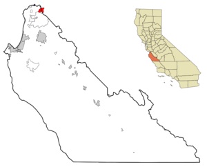
mapsize = 250x200px
map_caption = Location in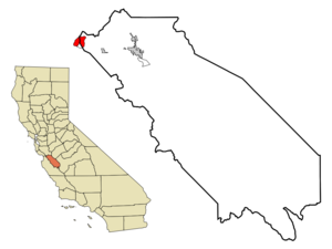
mapsize1 = 250x200px
map_caption1 = Location in San Benito County and the state ofCalifornia
subdivision_type = Country
subdivision_type1 = State
subdivision_type2 = Counties
subdivision_name =United States
subdivision_name1 =California
subdivision_name2 = Monterey, San Benito
government_type =
leader_title = N/A
leader_name =
leader_title1 = Senate
leader_name1 =Jeff Denham (R)
leader_title2 = Assembly
leader_name2 =Anna M. Caballero (D)
leader_title3 = U. S. Congress
leader_name3 =Sam Farr (D)
established_date =
area_magnitude =
area_total_km2 = 12.3
area_total_sq_mi = 4.7
area_land_km2 = 12.3
area_land_sq_mi = 4.7
area_water_km2 = 0
area_water_sq_mi = 0
elevation_ft = 131
elevation_m = 40
population_as_of = 2000
population_footnotes =
population_total = 2797
population_metro =
population_density_km2 = 227.4
population_density_sq_mi = 595.1
timezone = PST
utc_offset = -8
latd = 36 |latm = 53 |lats = 13 |latNS = N
longd = 121 |longm = 38 |longs = 29 |longEW = W
timezone_DST = PDT
utc_offset_DST = -7
postal_code_type =ZIP code
postal_code = 95004
area_code = 831
blank_name = FIPS code
blank_info = 06-02812
blank1_name = GNIS feature ID
blank1_info = 1657949
footnotes =
website =Aromas is a
census-designated place (CDP) in Monterey County, and San Benito County,California ,United States . The CDP straddles the border of the two counties, with Monterey County to the west and San Benito County to the east. Santa Cruz County sits less than a mile to the Northwest, and Santa Clara County about two miles to the North. The population was 2,797 at the 2000 census and was almost equally distributed between the two counties at 1,427 in Monterey County and 1,370 in San Benito County. Aromas is the only CDP in California that is divided between two or more counties. [ [http://factfinder.census.gov/servlet/GCTTable?_bm=y&-geo_id=04000US06&-_box_head_nbr=GCT-PH1&-ds_name=DEC_2000_SF1_U&-redoLog=false&-mt_name=DEC_2000_SF1_U_GCTPH1_ST2&-format=ST-7] Places in California, United States Census Bureau ]Geography
Aromas is located at coor dms|36|53|13|N|121|38|29|W|city (36.886988, -121.641396)GR|1.According to the
United States Census Bureau , the CDP has a total area of 4.753square mile s (12.311km² ). 4.747 square miles (12.295 km²) of it is land and 0.006 square miles (0.016 km²) or 0.13% is water. [ [http://factfinder.census.gov/servlet/DTTable?_bm=y&-context=dt&-ds_name=DEC_2000_SF1_U&-CONTEXT=dt&-mt_name=DEC_2000_SF1_U_P001&-tree_id=4001&-transpose=N&-redoLog=true&-all_geo_types=N&-_caller=geoselect&-geo_id=16000US0602812&-search_results=16000US0602812&-format=&-_lang=en&-show_geoid=Y] Aromas CDP, United States Census Bureau ]Demographics
As of the
census GR|2 of 2000, there were 2,797 people, 889 households, and 731 families residing in the CDP. Thepopulation density was 589.2 people per square mile (227.4/km²). There were 915 housing units at an average density of 192.7/sq mi (74.4/km²). The racial makeup of the CDP was 79.23% White, 0.18% Black or African American, 1.32% Native American, 2.61% Asian, 0.07% Pacific Islander, 11.01% from other races, and 5.58% from two or more races. 22.92% of the population were Hispanic or Latino of any race.There were 889 households out of which 45.0% had children under the age of 18 living with them, 68.6% were married couples living together, 7.9% had a female householder with no husband present, and 17.7% were non-families. 11.8% of all households were made up of individuals and 4.4% had someone living alone who was 65 years of age or older. The average household size was 3.15 and the average family size was 3.42.
In the CDP the population was spread out with 30.3% under the age of 18, 6.5% from 18 to 24, 29.1% from 25 to 44, 26.5% from 45 to 64, and 7.7% who were 65 years of age or older. The median age was 37 years. For every 100 females there were 100.6 males. For every 100 females age 18 and over, there were 98.2 males.
The median income for a household in the CDP was $69,145, and the median income for a family was $70,000. Males had a median income of $51,771 versus $41,875 for females. The
per capita income for the CDP was $25,220. About 5.7% of families and 6.2% of the population were below thepoverty line , including 7.2% of those under age 18 and 10.2% of those age 65 or over.The Aromas-San Juan School District has three schools – Aromas Elementary School, San Juan School and Anzar High School. Aromas has one K-8 school, Aromas Elementary School with less than 400 students, (in
2000 ). Stephanie Siddens is the current principal of Aromas School. Anzar High School, which opened in 1994, was named after early area pioneers.Aromas is also home to a
Granite Rock quarry.External links
* [http://www.asjusd.k12.ca.us/ Aromas-San Juan Unified School District]
References

Wikimedia Foundation. 2010.