- California State Route 174
Infobox road
state=CA
type=SR
route=174
section=474
maint=Caltrans 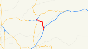
length_mi=13.096
length_ref=
length_round=3
history=State highway in 1933; SR 174 in 1964
direction_a=South
terminus_a=jct|state=CA|I|80 in Colfax
direction_b=North
terminus_b=jct|state=CA|SR|20|SR|49 in Grass Valley
previous_type=SR
previous_route=173
next_type=SR
next_route=175State Route 174 (SR 174) is a
state highway in theU.S. state ofCalifornia . The two-lane 13-mile (21 km) highway, added to the state highway system in 1933, connects Interstate 80 in Colfax with SR 20/SR 49 in Grass Valley, crossing the Bear River next to a 1924 concretearch bridge . The majority of the highway is eligible for the State Scenic Highway System, but local residents have blocked its designation due toproperty rights concerns.Route description
State Route 174 begins at exit 135 of I-80 in Colfax. Immediately after crossing I-80, the route turns right on Auburn Street and right again on Central Street, which bypasses downtown; a
business route follows Auburn Street, Grass Valley Street, and Main Street through downtown. SR 174 follows the oldLincoln Highway (US 40) north out of downtown to Rollins Lake Road, where the present state highway turns northwest along the Colfax Highway. It then crosses the Bear River from Placer County into Nevada County on a 1987 bridge, with the old 1924 bridge preserved for non-motorized traffic. The land flattens out as SR 174 curves north and west through theEmpire Mine State Historic Park into Grass Valley. Turning west on Colfax Avenue, the state highway passes under the SR 20/SR 49freeway before ending just beyond at Auburn Street, the former surface routing of SR 49.Google Maps street maps andUSGS topographic map s, accessed December 2007 via [http://mapper.acme.com/ ACME Mapper] ]History
The
Capital Construction Company began improving thecounty road between Colfax (on Route 37, signed as US 40) and Grass Valley (on Route 17) undercontract on September 29, 1931, ["Oakland Tribune ", Construction Started on Colfax Highway, September 30, 1931] and completed the work by mid-September 1932. [Oakland Tribune , Automotive Section, September 18, 1932] The state legislature placed it on the state highway system in 1933 as an extension of the existing Nevada City-Downieville Route 25. [cite CAstat|year=1933|ch=767|p=2035: "State Highway Route 37 near Colfax to State Highway Route 17 near Grass Valley."] [cite CAstat|year=1935|ch=29|p=277: "Route 25 is from: (a) Route 37 near Colfax to Route 17 near Grass Valley. (b) Nevada City to Route 83 near Sattley via Downieville."] In the 1964 renumbering, the highway received a signed designation, State Route 174.cite CAstat|year=1963|ch=385|p=1184: "Route 174 is from Route 80 near Colfax to Route 49 near Grass Valley."]Local residents created the Colfax Highway Association in 1967 at the Peardale firehouse, about halfway between the two ends, in order to preserve the
rural nature of the road. ["Sacramento Bee ", Highway Boosters Stay Ahead of Curve, August 17, 1997, p. N1] When the 21-foot (6.5 m) wide 1924 concretearch bridge that took SR 174 across the Bear River on the county line was set for replacement in the late 1980s, the group successfully lobbied to preserve it for non-motorized traffic. ["Sacramento Bee ", Slated for Razing, Span Gets Reprieve, January 14, 1987, p. B1] The association also pushed for Nevada County'sGold Country Stage bus service to add a route along the highway to Colfax, which was agreed to in late 1998 ["Sacramento Bee ", Bus Route to Penetrate Foothills' Last Transitless Corridor, December 10, 1998, p. N1] and still runs as Route 12, connecting downtown Grass Valley with Colfax's Amtrak station.Gold Country Stage , [https://docs.co.nevada.ca.us/dsweb/Get/Document-191080/ System Map] , updated September 2006] After a request by Nevada County in 1988, the state legislature designated the part of SR 174 in unincorporated Nevada County (between the county line and the Grass Valley city limits) as eligible for the State Scenic Highway System in 1991. [cite CAstat|year=1991|ch=775|p=3483] In 1999, the Colfax Highway Association attempted to get the route officially declared a State Scenic Highway. They argued that the designation would "protect the scenic character and rural flavor of the highway". A newly-formed group, Concerned Citizens for 174, opposed the designation because it would restrict theproperty rights of residents along the highway, for instance requiring them to use "natural colors". ["Sacramento Bee ", Scenic Highway Concept Spurs Alarm, March 25, 1999, p. N1] The opposition was successful, [Dave Moller,Union of Grass Valley , [http://www.theunion.com/apps/pbcs.dll/article?AID=/20040807/NEWS/40807009 CABPRO's Urke steps down] , August 7, 2004] and SR 174 remains eligible for State Scenic Highway status but is not a State Scenic Highway. [California Department of Transportation , [http://www.dot.ca.gov/hq/LandArch/scenic_highways/nevada.htm California Scenic Highway Mapping System: Nevada County] , accessed December 2007]Major intersections
:"Note: Except where prefixed with a letter, postmiles were measured in 1964, based on the alignment as it existed at that time, and do not necessarily reflect current mileage. The numbers reset at county lines; the start and end postmiles in each county are given in the county column."
References
External links
* [http://www.dot.ca.gov/hq/roadinfo/sr174 California Highway Conditions: SR 174]
* [http://www.cahighways.org/169-176.html#174 California Highways: SR 174]

Wikimedia Foundation. 2010.