California State Route 175
- California State Route 175
Infobox road
state=CA
type=SR
route=175
section=475
maint=Caltrans
length_mi=37.89
length_round=2
length_ref=[ [http://www.dot.ca.gov/hq/structur/strmaint/brlog2.htm January 1, 2006 California Log of Bridges on State Highways] ] ]
direction_a=West
terminus_a=jct|state=CA|US|101 at Hopland
junction=jct|state=CA|SR|29 near Lakeport
direction_b=East
terminus_b=jct|state=CA|SR|29 at Middletown
previous_type=SR
previous_route=174
next_type=SR
next_route=177
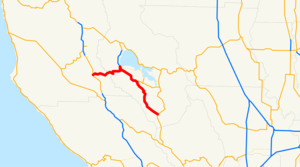
State Route 175 is a state highway in California, USA. It connects U.S. Route 101 at Hopland to State Route 29 near Lakeport through the Mayacamas Mountains. From there it joins Route 29 until Kelseyville, where it loops out until meeting Route 29 again at its end at Middletown. The section between Hopland and Lakeport is also known locally as the "Hopland Grade", or "Hopland Pass." Originally constructed in the early 1920s, it is one of the steepest and most difficult to drive of any California state highway. Indeed, until recently it was called the "crookedest road in California". Vehicles more than convert|39|ft|m in length are banned from the Hopland Grade, due to its many tight hairpin turns and curves.
Major intersections
:"Note: Except where prefixed with a letter, postmiles were measured in 1964, based on the alignment as it existed at that time, and do not necessarily reflect current mileage. The numbers reset at county lines; the start and end postmiles in each county are given in the county column."
References
Wikimedia Foundation.
2010.
Look at other dictionaries:
California State Route 29 — Autres noms Lake County Highway Saint Helena Highway Napa Vallejo Highway Sonoma Boulevard Longueur 170 km (106 mi) Direction nord / sud … Wikipédia en Français
California State Route 57 — State Route 57 Orange Freeway … Wikipedia
California State Route 29 — Infobox road state=CA type=SR route=29 section=329 maint=Caltrans length mi=106 length round=0 length ref= [ [http://www.dot.ca.gov/hq/structur/strmaint/brlog2.htm January 1, 2006 California Log of Bridges on State Highways] ] established=… … Wikipedia
California State Route 174 — Infobox road state=CA type=SR route=174 section=474 maint=Caltrans length mi=13.096 length ref= length round=3 history=State highway in 1933; SR 174 in 1964 direction a=South terminus a=jct|state=CA|I|80 in Colfax direction b=North terminus… … Wikipedia
California State Route 177 — Infobox road state=CA type=SR route=177 alternate name=Desert Center Rice Road section=477 maint= length mi=27.024 length round=3 length ref= direction a=South terminus a=jct|state=CA|I|10 near Desert Center direction b=North terminus b=jct|state … Wikipedia
Route californienne 29 — California State Route 29 California State Route 29 Autres noms Lake County Highway Saint Helena Highway Napa Vallejo Highway Sonoma Boulevard … Wikipédia en Français
Route de Californie 29 — California State Route 29 California State Route 29 Autres noms Lake County Highway Saint Helena Highway Napa Vallejo Highway Sonoma Boulevard … Wikipédia en Français
California Freeway and Expressway System — The California Freeway and Expressway System is a system of existing or planned freeways and expressways in the U.S. state of California. It is defined by the Streets and Highways Code.List of roads in the system*State Route 1 (part) *State Route … Wikipedia
List of highways numbered 175 — The following highways are numbered 175: Canada Quebec Route 175 Mexico Mexican Federal Highway 175 United States Interstate 175 (Florida) … Wikipedia
Liste der State-, U.S.- und Interstate-Highways in Kalifornien — Dies ist eine Aufstellung von State Highways in Kalifornien, USA nach Nummern. Inhaltsverzeichnis 1 State Routes 2 Interstates 2.1 Zubringer und Umgehungen 3 U.S. Highways … Deutsch Wikipedia
