- California State Route 29
Infobox road
state=CA
type=SR
route=29
section=329
maint=Caltrans 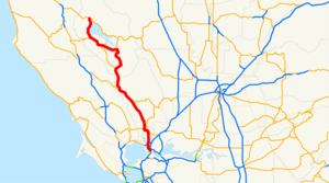
length_mi=106
length_round=0
length_ref= [ [http://www.dot.ca.gov/hq/structur/strmaint/brlog2.htm January 1, 2006 California Log of Bridges on State Highways] ]
established=
direction_a=South
terminus_a=jct|state=CA|I|80 in Vallejo
junction=jct|state=CA|SR|12 near Napa
jct|state=CA|SR|128 in Calistoga
jct|state=CA|SR|53 near Clearlake
jct|state=CA|SR|175 near Lakeport
direction_b=North
terminus_b=jct|state=CA|SR|20 at Upper Lake
previous_type=SR
previous_route=28
next_type=SR
next_route=32State Route 29 is a
state highway in theU.S. state ofCalifornia that travels in a north-south direction from State Route 20 in Upper Lake to Interstate 80 in Vallejo.This route is part of the
California Freeway and Expressway System [http://www.leginfo.ca.gov/cgi-bin/displaycode?section=shc&group=00001-01000&file=250-257 CA Codes (shc:250-257)] ] and is eligible for the State Scenic Highway System [http://www.leginfo.ca.gov/cgi-bin/displaycode?section=shc&group=00001-01000&file=260-284 CA Codes (shc:260-284)] ] .Route description
SR 29 starts as a two-lane highway until Lakeport and becomes a freeway as it bypasses the city. South of the city, it reverts back to a highway, going around
Clear Lake , the largest natural freshwater lake completely within California, passing through Kelseyville, Lower Lake, and Middletown. It then climbsMount Saint Helena , an extinctvolcano , at the border between Lake County and Napa County. Through Napa Valley, the highway passes through Calistoga, St. Helena, Rutherford, Oakville, Yountville and Napa while passing many of the region's notable vineyards and wineries.At the city of Napa the road briefly becomes a freeway again and returns to a four-lane highway (at some parts five) the remainder of the route, terminating at I-80 near the Al Zampa Bridge in Vallejo.
Historically, the route between Middletown and the Napa Valley was served by the Old Bull Trail Road, built by volunteers in the
1850s that had grades up to 35 percent. That was replaced by the St. Helena Toll Road in1868 , which had more manageable inclines of up to 12 percent. The State of California purchased the toll road in1925 .Points of interest
*
Lower Lake Stone Jail (California Historical Landmark (CHL) #429) is just south of the intersection of State Route 53 in Lower Lake.
*CHL #450, the Stone House, is at the corner of Hidden Valley Rd., north of Middletown.
*The marker for CHL #467, St. Helena Toll Road and Bull Trail, can be found at the intersection of Hill Ave in Middletown (postmile LAK 5.5).
*Robert Louis Stevenson State Park CHL #710 located near the county line between Lake and Napa Counties at the summit of Mount Saint Helena.
*Bale Grist Mill State Historic Park CHL #359 between Calistoga and St. Helena.
*Bothe-Napa Valley State Park between Calistoga and St. HelenaMajor intersections and exit list
:"Note: Except where prefixed with a letter,
postmile s were measured in 1964, based on the alignment as it existed at that time, and do not necessarily reflect current mileage. The numbers reset at county lines; the start and end postmiles in each county are given in the county column."References
External links
* [http://www.westcoastroads.com/california/ca-029.html California @ WestCoastRoads - State Route 29]
* [http://www.dot.ca.gov/hq/roadinfo/sr29 Caltrans: Route 29 highway conditions]
* [http://www.cahighways.org/025-032.html#029 California Highways: SR 29]
* [http://www.dot.ca.gov/hq/traffops/signtech/calnexus/reports/twentyninenorth.htm Cal-NExUS: Route 29 North]
* [http://www.dot.ca.gov/hq/traffops/signtech/calnexus/reports/twentyninesouth.htm Cal-NExUS: Route 29 South]

Wikimedia Foundation. 2010.