- Utah State Route 103
Infobox road
state=UT
type=SR
alternate_name=650 North
route=103
section=116
maint=UDOT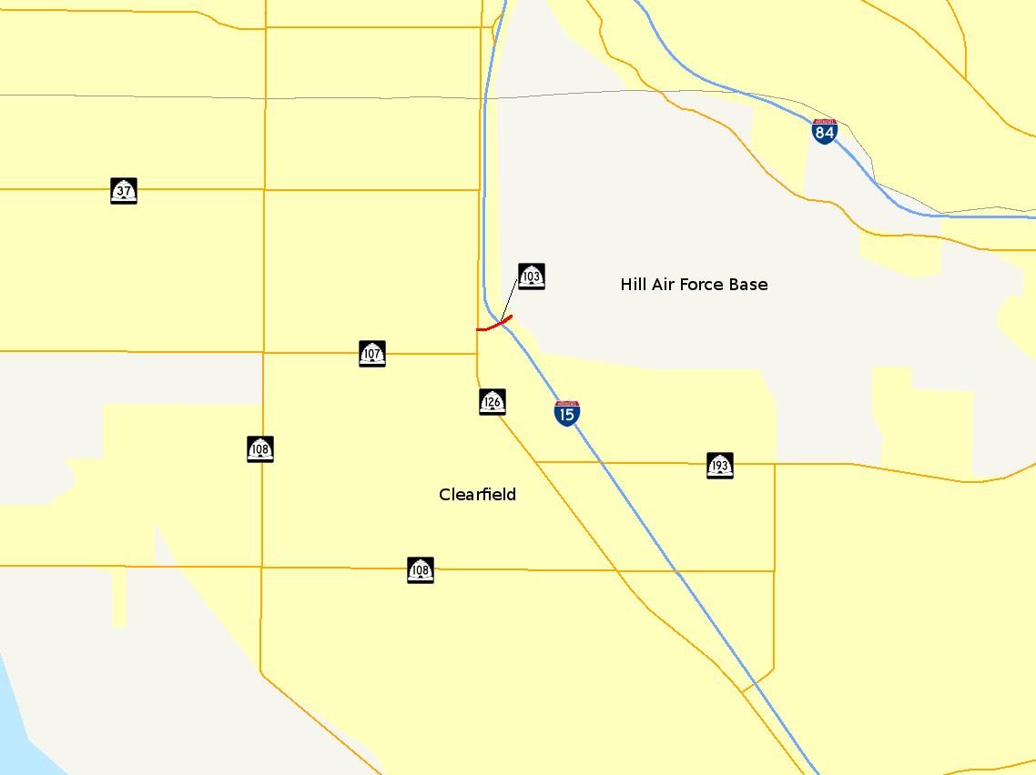
map_notes=SR-103 highlighted in red
length_mi=0.225
length_round=3
length_ref=cite web|title=Route 103|date=2008-05-01|work= [http://www.udot.utah.gov/main/f?p=100:pg:3977778294530221:::1:T,V:814 Highway Reference] |url=http://www.udot.utah.gov/main/uconowner.gf?n=15466206666581740|publisher=Utah Department of Transportation |accessdate=2008-08-20|format=PDF]
established=1965
direction_a=West
starting_terminus=jct|state=UT|SR|126 in Clearfield
junction=jct|state=UT|I|15 in Clearfield
direction_b=East
ending_terminus=Hill Air Force Base west access gate
previous_type=SR
previous_route=102
next_type=SR
next_route=104State Route 103 (SR-103) is a convert|0.225|mi|km|3|adj=on long
state highway in theU.S. state ofUtah . It branches off from SR-126 in downtown Clearfield and extends east to Interstate 15 (I-15), terminating atHill Air Force Base . The entire route is located in Davis County and was formed in 1965 coinciding with the construction of I-15.Route description
Located entirely in Davis County, SR-103 begins at the intersection of Main Street, Clearfield, (SR-126) and 650 North. The highway takes a gentle northerly turn, crossing over the Davis–Weber Canal as a five lane road, with two lanes each direction and a center turn lane. SR-103 intersects I-15 at a pair of
traffic light s before crossing what was once the path of aUnion Pacific Railroad line, which has been paved over and replaced by a parking lot on the south eastern side of SR-103 for the Pass & Registration office. Visible past the office is aF-16 monument, located on the base.cite map |publisher=United States Air Force |title=Hill AFB West Area |url=http://www.hill.af.mil/shared/media/document/AFD-070710-039.pdf |year=2007 |cartography=MARCOA Publishing |page=60 |accessdate=2008-09-29] The highway has now gained another lane in each direction, but has lost its center turn lane. Directly northeast, 6th Street passes near but does not connect to the highway. The eastern terminus of SR-103 is a gate granting access to authorized Hill Air Force Base personnel.cite map|url=http://maps.google.com/maps?f=q&hl=en&geocode=&q=state+route+103&sll=41.134225,-112.022824&sspn=0.006658,0.012531&ie=UTF8&ll=41.123865,-112.023768&spn=0.00333,0.006266&t=h&z=17 |publisher=Google Maps |cartography=NAVTEQ |title=SR-103 Overview|accessdate=2008-09-26] SR-103 is one of four Utah state highways that connect to Hill Air Force Base, the others being SR-97,cite web|url=http://www.sr.ex.state.ut.us/main/uconowner.gf?n=47513723098186660|title=Route 97|date=January 2006|work= [http://www.udot.utah.gov/main/f?p=100:pg:3977778294530221:::1:T,V:814 Highway Reference] |publisher=Utah Department of Transportation|accessdate=2008-08-26|format=PDF] SR-168cite web|url=http://www.sr.ex.state.ut.us/main/uconowner.gf?n=15550418506765007|title=Route 168|date=November 2005|work= [http://www.udot.utah.gov/main/f?p=100:pg:3977778294530221:::1:T,V:814 Highway Reference] |publisher=Utah Department of Transportation|accessdate=2008-08-26|format=PDF] and SR-232,cite web|url=http://www.sr.ex.state.ut.us/main/uconowner.gf?n=7193512317884619|title=Route 232|date=November 2005|work= [http://www.udot.utah.gov/main/f?p=100:pg:3977778294530221:::1:T,V:814 Highway Reference] |publisher=Utah Department of Transportation|accessdate=2008-08-26|format=PDF] and has the second lowest average daily traffic, higher only than SR-168.For the year 2007, a daily average of 22,525 cars traveled along SR-103, representing only a slight growth from previous years (in 2006, the average was 22,215; in 2005, 21,275).cite web|url=http://www.udot.utah.gov/main/uconowner.gf?n=2363711025498494585|format=PDF|title=Traffic on Utah Highways - 2007|date=2008-07-02|publisher=Utah Department of Transportation|pages=pg 25|accessdate=2008-08-21] Three percent of this traffic was composed of trucks.cite web|url=http://www.udot.utah.gov/main/uconowner.gf?n=2363733707060508179|format=PDF|title=Truck Traffic on Utah Highways - 2007|date=2008-07-02|publisher=Utah Department of Transportation|pages=pg 24|accessdate=2008-08-21] The average traffic measurement is collected at a point on SR-103 between the interchange with I-15 and Hill Air Force Base.
History
SR-103, constructed in 1965, connected the former
U.S. Route 91 (US-91) to Hill Air Force Base, with an intermediate connection to I-15. US-91 before the formation of I-15 was the major thoroughfare through Utah, connecting it to California and Montana.cite map |publisher=United States Department of Agriculture |title=United States System of Highways |url=http://upload.wikimedia.org/wikipedia/commons/5/55/1926us.jpg|year=1926 |accessdate=2008-09-26] SR-103 serves the important function of connecting the town of Clearfield, and residents along I-15 to Hill Air Force Base. The base, as of 2002, was the fifth largest employer in the state of Utah. It is the second largest employer which is neither the state government or a state-funded higher education institution.cite web|url=http://relocate2.utah.gov/workforce/largestemployers.html|title=Utah's Largest Employers|work=Corporate Site Selection|publisher=Governor's Office of Economic Development|accessdate=2008-09-20] The route has been mostly unchanged since its formation, except for the name of the road that the highway is on. Originally the street SR-103 was routed along was named 600 North, but it was changed to 650 North in 1979, still using the same alignment.cite web|url=http://www.udot.utah.gov/main/uconowner.gf?n=200609181312471|format=PDF|title=Route 103|date=November 2007|work= [http://www.udot.utah.gov/main/f?p=100:pg:3977778294530221:::1:T,V:1348 Highway Resolutions] |publisher=Utah Department of Transportation|accessdate=2008-08-20]Major intersections
{|class=wikitable!Locationcite map|publisher=Utah Department of Transportation|title=Wasatch Front Highway Map|url=http://www.udot.utah.gov/main/uconowner.gf?n=41979620535238803|accessdate=2008-08-16] !Mile!Junction!Notes
-Jctint
state=UT
location=Clearfield
lspan=2
mile=0.000
road=jct|state=UT|SR|126|name1=Main Street
notes=Western terminusJctint
state=UT
mile=0.080–0.174
road=jct|state=UT|I|15|city1=Salt Lake City|city2=OgdenJctint
state=UT
location=
mile=0.225
road=West access gate,Hill Air Force Base
notes=Eastern terminusReferences
Wikimedia Foundation. 2010.