- Utah State Route 126
Infobox road
state=UT
type=SR
route=126
section=118
maint=UDOT 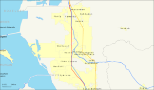
length_mi=21.609
length_round=3
length_ref=cite web | title=State Route 126 Highway reference | publisher=Utah Department of Transportation | url=http://www.dot.utah.gov/main/uconowner.gf?n=15509627715682499 ]
established=1935 as SR-84; renumbered 1977
direction_a=South
terminus_a=jct|state=UT|I|15 in Layton
junction=jct|state=UT|SR|108 in Layton
jct|state=UT|SR|39 in Marriott-Slaterville
jct|state=UT|I|15|I|84 in South Willard
direction_b=North
terminus_b=jct|state=UT|US|89 in South Willard
previous_type=SR
previous_route=125
next_type=SR
next_route=127State Route 126 (SR-126) is a highway completely within the
Ogden-Clearfield metropolitan area in northernUtah that makes a loop around Interstate 15 in its more than twenty-one mile path. The street is given the names Main Street, 1900 West and 2000 West respectively from south to north. Previous to1977 , SR-126 was a road in southern Utah. A portion of the highway is an old routing of US-91.Route description
After its southern terminus, the route heads northwest in Layton. After entering Clearfield, the route turns straight to the north. It continues this direction through Sunset, Roy, and West Haven before veering to the northwest when the highway reaches Marriott-Slaterville. The route again reverts to a northerly direction before reaching Farr West. Just before terminating in South Willard, the route turns northwest one final time.
The entirety of the route, with the exception of a small portion from the Interstate 15/Interstate 84 junction to the northern terminus, lies west of the aforementioned interstates.
History
The first iteration of SR-126 was originally created in
1931 . This route went from Greenville to SR-21 just west of Beaver. It was deleted from the state route system in1969 .The portion of what is now numbered SR-126 from the southern terminus to the junction with SR-26 was previously part of US-91.cite map
url=http://www.broermapsonline.org/members/NorthAmerica/UnitedStates/NorthernRockies/randmcnally_ra_1946_020.html
title=Rand McNally Road Atlas
page=22
publisher=Rand McNally, (hosted by Broer Map Library)
year=1946] The northern portion of what is now SR-126 was numbered State Route 84 starting in 1953.cite web
title=Highway Resolution SR-84
publisher=Utah Department of Transportation
url=http://www.dot.utah.gov/main/uconowner.gf?n=200609181109591
accessdate=2008-05-18] In 1974, US-91 was eliminated throughout most of Utah,cite web
url=http://www.dot.utah.gov/main/uconowner.gf?n=200609181116091
title=Highway Resolution route 91
publisher=Utah Department of Transportation
accessdate=2008-03-08] and SR-84 absorbed the portion of former US-91 from Layton to Roy.The
1977 Utah state route renumbering was implemented, in part, to eliminate instances where a state route used the same number as aU.S. Route orInterstate route in the state. As the 84 designation was also in use for Interstate 84 most of SR-84 was renumbered to SR-126. The only change from then to now was a portion of the old highway that was relinquished to be used by the city of Layton for parking lots in1991 .cite web | title=State Route 126 History | publisher=Utah Department of Transportation | url=http://www.dot.utah.gov/main/uconowner.gf?n=200609181323351 ]Major intersections
{|class=wikitable!County!Locationcite web
publisher=Utah Department of Transportation
title=State Highway Map
url=http://www.udot.utah.gov/main/f?p=100:pg:2117854713443240831::::V,T:,346
accessdate=18 May
accessmonth=
accessyear=2008] cite web | title=Utah Code -- Title 72 -- Chapter 04 -- Section 118 -- Designation of State Highways Act | url=http://le.utah.gov/~code/TITLE72/htm/72_04_011800.htm | accessdate=2008-08-06 | publisher=Utah State Legislature ]!Mile!Junction!Notes
-Jctint
state=UT
county=Davis
cspan=8
location=Layton
lspan=4
mile=0.000-0.164
road=Jct|state=UT|I|15|city1=Salt Lake City
notes=Southern terminus
Northbound exit, southbound entranceJctint
state=UT
mile=0.494
road=Jct|state=UT|SR|109|name1=Gentile Street|dir1=eastJctint
state=UT
mile=1.591
road=Jct|state=UT|SR|232|name1=Hill Field Road|dir1=eastJctint
state=UT
mile=3.218
road=Jct|state=UT|SR|108|name1=Antelope Drive|city1=Antelope IslandJctint
state=UT
mile=4.468
location=Clearfield
lspan=3
road=Jct|state=UT|SR|193|name1=700 South|dir1=eastJctint
state=UT
mile=5.661
road=Jct|state=UT|SR|107|dir1=west|name1=300 NorthJctint
state=UT
mile=6.007
road=Jct|state=UT|SR|103|I|15|to2=yes|dir1=east|name1=650 NorthJctint
state=UT
location=Sunset
mile=7.169
road=Jct|state=UT|SR|37|dir1=west|name1=1800 NorthJctint
state=UT
county=Weber
cspan=7
location=Roy
lspan=4
mile=8.678
road=Jct|state=UT|SR|97|name1=5600 SouthJctint
state=UT
mile=9.073
road=Jct|state=UT|SR|26|I|15|I|84|to2=yes|to3=yes|dir1=east|name1=Riverdale RoadJctint
state=UT
mile=11.174
road=Jct|state=UT|SR|79|dir1=east|name1=Hinckley DriveJctint
state=UT
mile=11.697
road=Jct|state=UT|SR|108|dir1=west|name1=Midland DriveJctint
state=UT
location=West Haven
mile=13.307
road=Jct|state=UT|SR|104|dir1=east|name1=Wilson LaneJctint
state=UT
location=Marriott-Slaterville
mile=14.431
road=Jct|state=UT|SR|39|name1=12th StreetJctint
state=UT
location=Farr West
mile=18.718
road=Jct|state=UT|SR|134|name1=2700 NorthJctint
state=UT
county=Box Elder
cspan=2
location=South Willard
mile=21.021-21.278
road=Jct|state=UT|I|15|I|84|city1=TremontonJctint
state=UT
location=Hot Springs Junction
mile=21.609
road=Jct|state=UT|US|89|city1=Brigham City|city2=Logan
notes=Northern terminusReferences

Wikimedia Foundation. 2010.