- Sacramento
-
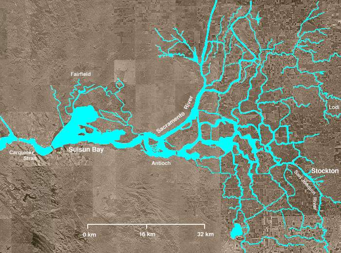
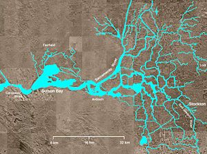 Northern California's Sacramento-San Joaquin River Delta. The Sacramento River flows into the delta from the north and the San Joaquin River from the south through Stockton.
The Sacramento-San Joaquin River Delta, or California Delta, is an expansive inland river delta and estuary in northern California in the United States. The Delta is formed at the western edge of the Central Valley by the confluence of the Sacramento and San Joaquin rivers and lies just east of where the rivers enter Suisun Bay (an upper arm of San Francisco Bay). The Delta is recognized for protection by the California Bays and Estuaries Policy.[1] The city of Stockton is located on the San Joaquin River on the eastern edge of the delta.
Contents
Description
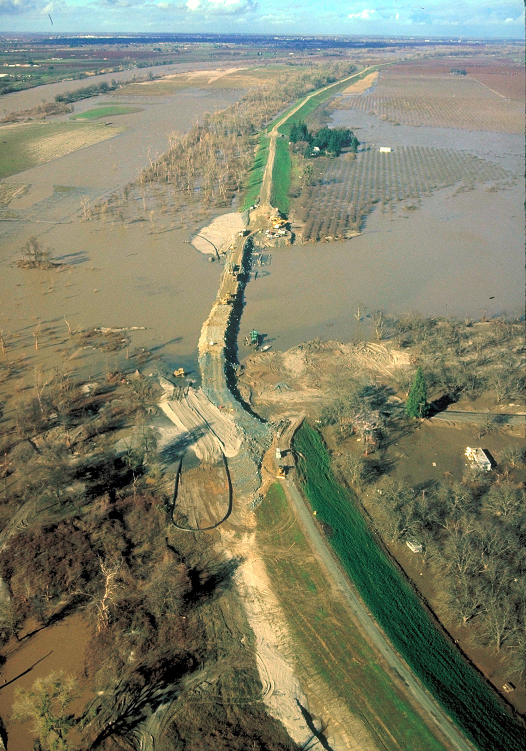
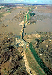 A broken levee and resultant flooding in the Sacramento delta. The U.S. Army Corps of Engineers is repairing the levee.
The Sacramento-San Joaquin River Delta is an example of an inverted river delta, one of only a few worldwide. It is the largest estuary on the United States' Pacific Coast.[2] The fan-like area of the delta moves downstream, as the two rivers are forced to exit the Central Valley through the Coast Range via the narrow channel known as the Carquinez Strait, which leads to the San Francisco Bay and mainly the Pacific Ocean through the Golden Gate.
The delta consists of myriad small natural and man-made channels (locally called sloughs), creating a system of isolated lowland islands and wetlands defined by dikes or levees. The delta islands are not islands in the classic sense, but are referred to as such because they are completely surrounded by water and are so isolated in many cases that they are accessible only by boat, ferry or aircraft.
An extensive system of earthen levees has allowed widespread farming throughout the delta. Its peat soil makes it one of the most fertile agricultural areas in California and arguably even the nation, contributing billions of dollars to the state's economy. Certain specialty crops, such as asparagus, are grown in the delta in quantities unmatched anywhere else in the United States.
The delta and its "Thousand Miles of Waterways" are a recreation destination. The warm, breezy summers are popular among water skiers and boaters and even the chilly, foggy winters draw fishermen and hunters.
Development
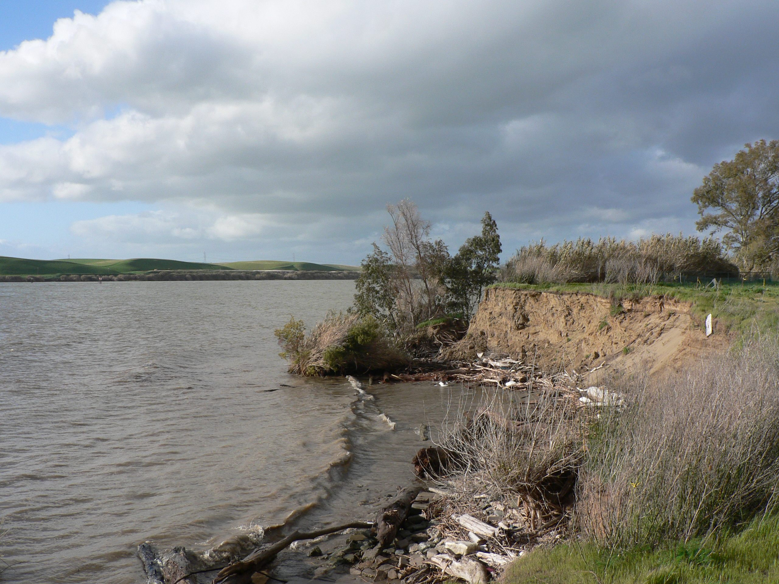
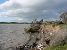 A view from Windy Cove, inside the delta
The delta is an estuary which acts as the funnel for a drainage basin covering thousands of square miles of California's land. Ultimately flowing into the Pacific Ocean, runoff moves through, and into, the delta from several major mountain ranges, including virtually the entire western flank of the Sierra Nevada, the southern reaches of the Cascade Range, and the eastern flanks of those parts of the Pacific Coast Range that border California's Central Valley. For thousands of years, huge swaths of the delta flooded regularly with every spring melt, and the delta represented one of the largest estuaries on North America's west coast.
Starting in the late 19th century, Chinese workers were used to construct hundreds of miles of levees throughout the delta's waterways in an effort to reclaim and preserve farmland and control flooding. These levees confine waterflow to the riverbeds.
Levee failures in the delta can result in the flooding of vast tracts of both agricultural land and developed cities. On 3 June 2004, a 350 foot (110 m) section of a levee 10 mi (16 km) west of Stockton collapsed, flooding the Upper and Lower Jones Tracts, a 12,000 acres (4,900 ha) island.[3] Tens of thousands of people live near these levees (in many cases, right next to them), in scores of communities ranging from Tracy in the south to Stockton in the east, Sacramento in the north, and the San Francisco Bay area in the west. In light of the 2005 Hurricane Katrina disaster affecting similarly low-lying river delta regions in Louisiana and Mississippi, there has been a strong outcry for the state of California and/or the federal government to thoroughly inspect and, if necessary, strengthen and repair the delta's levees.
Construction and history
The total area is around 1,100 square miles (2,800 km2), around 70 reclaimed islands and tracts, surrounded by 1,100 miles (1,800 km) of levees surrounded by 700 miles (1,100 km) of waterways. The delta was originally marshland; reclamation was made by the building of levees, by Chinese laborers in the 1850s.
A typical levee was constructed as being approximately trapezoidal, 10 ft (3.0 m) above original ground level, and approximately 30 ft (9.1 m) wide at the base rock armoured on the river side. The construction was a colossal engineering undertaking.
Effects of the Levee System and Freshwater Diversion
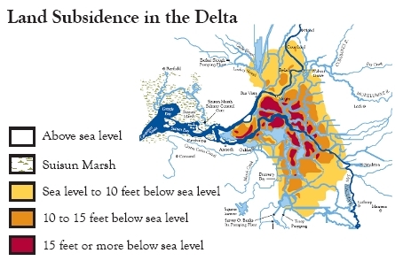
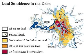 Land Subsidence in the Delta 1995
The levee system allowed farmers to drain and reclaim almost a 500,000 acres (2,000 km2) of the Delta, then a tidal marsh. Once the rivers were confined to their riverbeds, the peat soil of the former tidal marsh was exposed to oxygen. As the oxygen-rich peat soil decomposed and then released carbon dioxide, profound subsidence of the land resulted. Now, most the Delta is below sea level, and a great deal of the western and central Delta is at least 15 feet (4.6 m) below sea level. Land subsidence renders unstable the Delta’s 1,100-mile (1,800 km) system of protective levees, instigating levee failure and subsequent flooding. Land subsidence also allows saltwater intrusion into the Delta, compounded by water diversions that remove 40% of the freshwater flowing into the Delta. Loss of freshwater in the Delta has had a profound effect on the ecology of the Delta.[4]
Ecology
Further, the Delta's fish population is in question. The Delta is home to approximately 22 species of fish including the Delta smelt, a key indicator species for the health of the Delta's ecosystem. In 2004, the Delta smelt was found to be on the edge of extinction.[2]
Current status
The administration of the region is also in flux. CALFED, a federal-state program in charge of the Delta, is on the verge of financial insolvency.
A number of solutions have been proposed. A first set of alternatives would maintain the Delta in its current homogeneous freshwater state. The second would return the Delta to a heterogeneous mixed salt water-fresh water body, and would serve in the Delta's current water-supply with a series of aqueducts.
The Contra Costa County Public Works Department is working with the California Coastal Commission and the Department of Boating and Waterways to protect the drinking water quality, prevent pollution and environmental health of the Delta.[2]
A strong movement is emerging to construct a Peripheral Canal to redirect water flowing from the Sacramento and San Joaquin rivers directly to man-made aqueducts headed south and west. Senator Diane Feinstein and Governor Arnold Schwarzenegger have both declared their support for such a project.
All solutions, however, aim to produce a Delta which simultaneously supports a vibrant ecosystem and continues to supply fresh water to the Central Valley Project, the State Water Project and the Bay Area.[5]
In April 2009, the Sacramento River Delta was declared the nation's most endangered waterway system by the environmental group American Rivers, due to water shortages caused by the Delta's environmental problems, declining fish populations and aging levees, among other problems.[6]
Major tributaries
Islands
- Category: Islands of the Sacramento-San Joaquin Delta
See also
- CALFED Bay-Delta Program
- John P. Irish, Delta landowner
References
- ^ State Water Resources Control Board Water Quality Control Policy for the Enclosed Bays and Estuaries of California (1974) State of California
- ^ a b c http://www.coastal.ca.gov/ccbn/keep_the_delta_clean.html
- ^ http://modeling.water.ca.gov/delta/reports/annrpt/2005/2005Ch3.pdf modeling.water.ca.gov
- ^ Bay Delta Blog (Sept. 20, 2009). "Bay-Delta: Levees, Climate Change, and Water Quality". http://baydelta.wordpress.com/2009/09/20/bay-delta-levees-climate-change-and-water-quality/. Retrieved Apr. 29, 2010.
- ^ http://www.ppic.org/content/pubs/rb/RB_207JLRB.pdf
- ^ http://www.sacbee.com/topstories/story/1760320.html
External links
- California Delta Chambers and Visitors Bureau
- Delta Wetlands Project
- Sacramento-San Joaquin Delta Atlas at California Department of Water Resources
- What is this place called the Delta? (slideshow)
- Delta Waterways at California Department of Water Resources
- SFGate: Deluge in the Delta (4 Jun 2004)
- Cnet -- Visiting SF Bay (and delta) in a warehouse. Article by Daniel Terdimen, photos by James Martin, Cnet News, Aug 27, 2007
- Cnet -- Barge-scale cleanup in California waterways (photos), by James Martin, March 20, 2010
- Cnet -- Engineering a massive cleanup of toxic waterways (photos), by James Martin, March 20, 2010
- San Joaquin Delta Land Reclamation Photographs, ca. 1904-1907, The Bancroft Library
Coordinates: 38°04′05″N 121°50′34″W / 38.067975°N 121.8427354°W
Categories:- Sacramento-San Joaquin Delta
- River deltas
- Estuaries of California
- San Joaquin Valley
- Central Valley of California
- Landforms of Sacramento County, California
- Geography of the San Francisco Bay Area
- Sacramento River
- Regions of California
- Landforms of San Joaquin County, California
- Rivers of California
Wikimedia Foundation. 2010.