- California State Route 198
Infobox road
state=CA
type=SR
route=198
section=498
maint=Caltrans 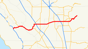
length_mi=141.273
length_round=3
length_ref=
length_notes=(plus about 8.5 mi (14 km) on SR 33)
direction_a=West
terminus_a=jct|state=CA|US|101 near San Lucas
junction=jct|state=CA|SR|33 in Coalinga
jct|state=CA|I|5 near Coalinga
jct|state=CA|SR|41 in Lemoore
jct|state=CA|SR|43 near Hanford
jct|state=CA|SR|99 in Visalia
jct|state=CA|SR|63 in Visalia
direction_b=East
terminus_b=Sequoia National Park
previous_type=SR
previous_route=197
next_type=US
next_route=199State Route 198 is an east-west state highway that connects the California Central Coast to the mid-Central Valley at Visalia, although the most-traveled portion is in the Central Valley itself.
This route is part of the
California Freeway and Expressway System [http://www.leginfo.ca.gov/cgi-bin/displaycode?section=shc&group=00001-01000&file=250-257 CA Codes (shc:250-257)] ] and is eligible for the State Scenic Highway System [http://www.leginfo.ca.gov/cgi-bin/displaycode?section=shc&group=00001-01000&file=260-284 CA Codes (shc:260-284)] ] .Route description
The road begins at a remote interchange with U.S. Route 101 south of King City in the Salinas River Valley. Leaving Route 101, SR 198 passes through the Priest Valley, climbs the Coast Range as a two-lane road, and crosses over an unnamed pass; it then descends along Warthan Canyon to the town of Coalinga, where it joins with SR 33.
Portions of the highway between U.S. Route 101 and Coalinga contain several switchback turns making freight hauling difficult through this part of the Coast Range. Freight haulers are advised to use SR 46 to the south instead.
On both sides of Coalinga the road passes through the enormous
Coalinga Oil Field , which was the largest-producing field in California in the first decade of the 20th century. Production continues there, as is evident from the number ofnodding donkey s a traveler sees in this vicinity. After going through Coalinga, the road becomes flatter.SR 198 then intersects Interstate 5 in Fresno County before becoming a freeway west of Lemoore. The landscape become a bit less rural as it goes through Hanford, where it quickly reverts to a two-lane road until entering Tulare County and the
freeway -to-freeway interchange with SR 99 as it entersVisalia , the largest city it will intersect. It will remain a freeway until east of Visalia, where the road starts to climb the Sierra Nevada and it ends atSequoia National Park . This is the main route from both the Los Angeles and San Francisco Bay areas to Sequoia National Park.History
All of SR 198 was added to the state highway system in the three
bond issue s floated to pay for the construction of the system. The first bond issue, approved by the state's voters in 1910, included the road from Visalia west to Hanford, connecting the twocounty seat s with the central north-south highway (Route 4, now SR 99). As part of the 1916 bond issue, the route was extended west from Hanford through Coalinga to the coast trunk highway (Route 2, now US 101) near San Lucas, and assigned it the Route 10 designation. The third bond issue, passed in 1919, included a further extension east from Visalia toSequoia National Park . [Howe & Peters, [http://books.google.com/books?id=G0w7AAAAMAAJ&pg=PA3#PRA1-PA3,M1 Engineers' Report to California State Automobile Association Covering the Work of the California Highway Commission for the Period 1911-1920] , pp. 11-16] The entire length of Route 10 was marked as Sign Route 198 in 1934, [California Highways and Public Works , [http://www.gbcnet.com/roads/ca_routes_1934.html State Routes will be Numbered and Marked with Distinctive Bear Signs] , August 1934] and this number was adopted legislatively in the 1964 renumbering. [cite CAstat|year=1963|ch=385|p=1185] The portion east of I-5 near Coalinga was added to theCalifornia Freeway and Expressway System in 1959, [cite CAstat|year=1959|ch=1062|p=3112: "Route 10 from Route 238 [I-5] near Coalinga to Sequoia National Park."] and parts of it have been built as such.Major intersections and exit list
:"Note: Except where prefixed with a letter,
postmile s were measured in 1964, based on the alignment as it existed at that time, and do not necessarily reflect current mileage. The numbers reset at county lines; the start and end postmiles in each county are given in the county column."References
External links
* [http://www.westcoastroads.com/california/ca-198.html California @ WestCoastRoads.com - State Route 198]
* [http://www.dot.ca.gov/hq/roadinfo/sr198 Caltrans: Route 198 highway conditions]
* [http://www.cahighways.org/193-200.html#198 California Highways: SR 198]

Wikimedia Foundation. 2010.