California State Route 269
- California State Route 269
Infobox road
state=CA
type=SR
route=269
section=569
maint=Caltrans
length_mi=30
length_round=0
length_ref= [ [http://www.dot.ca.gov/hq/structur/strmaint/brlog2.htm January 1, 2006 California Log of Bridges on State Highways] ]
direction_a=South
terminus_a=jct|state=CA|SR|33 in Avenal
direction_b=North
terminus_b=jct|state=CA|SR|145 near Kerman
previous_type=SR
previous_route=267
next_type=SR
next_route=270
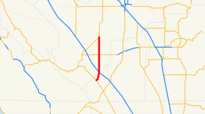
State Route 269 is a state highway in California, USA, which runs from Avenal to State Route 145.
Route description
The southern terminus of SR 269 is at State Route 33 in Avenal, where it drops into the San Joaquin Valley at I-5. In the city of Avenal, it is known as "Skyline Boulevard." From the Fresno-Kings county line, right before I-5 to its northern terminus at SR 145, the road is known as "Lassen Avenue" and heads due north through Huron.
Major Cities
Bolded cities are designated as Control cities.
Avenal all Southbound
Huron Northbound till Huron City Limits, same Southbound
Five Points SR 269's Northern Terminus
Major intersections
:"Note: Except where prefixed with a letter, postmiles were measured in 1964, based on the alignment as it existed at that time, and do not necessarily reflect current mileage. The numbers reset at county lines; the start and end postmiles in each county are given in the county column."
External links
* [http://www.dot.ca.gov/hq/roadinfo/sr269 Caltrans: Route 269 highway conditions]
* [http://www.cahighways.org/265-272.html#269 California Highways: Route 269]
* [http://www.geocities.com/bennyp81/ca269.html The Big Highways Page: California Route 269]
References
Wikimedia Foundation.
2010.
Look at other dictionaries:
California State Route 33 — CA 33 redirects here. For the congressional district, see California s 33rd congressional district. State Route 33 … Wikipedia
California State Route 267 — Infobox road state=CA type=SR route=267 section=567 maint=Caltrans length mi=12.69 length round=2 length ref= [ [http://www.dot.ca.gov/hq/structur/strmaint/brlog2.htm January 1, 2006 California Log of Bridges on State Highways] ] direction a=West … Wikipedia
California State Route 270 — Infobox road state=CA type=SR route=270 section=570 maint=Caltrans alternate name=Bodie Road length mi=9.805 length round=3 length ref= direction a=West terminus a=jct|state=CA|US|395 near Bridgeport direction b=East terminus b=Bodie previous… … Wikipedia
California Freeway and Expressway System — The California Freeway and Expressway System is a system of existing or planned freeways and expressways in the U.S. state of California. It is defined by the Streets and Highways Code.List of roads in the system*State Route 1 (part) *State Route … Wikipedia
List of highways numbered 269 — The following highways are numbered 269: Canada Quebec Route 269 United States Interstate 269 (future) Alabama State Route 269 … Wikipedia
Liste der State-, U.S.- und Interstate-Highways in Kalifornien — Dies ist eine Aufstellung von State Highways in Kalifornien, USA nach Nummern. Inhaltsverzeichnis 1 State Routes 2 Interstates 2.1 Zubringer und Umgehungen 3 U.S. Highways … Deutsch Wikipedia
Avenal, California — Infobox Settlement official name = Avenal, California settlement type = City imagesize = image caption = image imagesize = image caption = image mapsize = 250x200px map caption = Location in Kings County and the state of California mapsize1 = map … Wikipedia
Ruta Estatal de California 33 — Ruta Estatal 33 … Wikipedia Español
Orange County, California — For other uses, see Orange County (disambiguation). Coordinates: 33°40′N 117°47′W / 33.67°N 117.78°W / 33.67; 117.78 … Wikipedia
Fresno County, California — County of Fresno County Seal … Wikipedia
