- North Tustin, California
-
North Tustin
Tustin Foothills— census-designated place — Location in Orange County and the state of California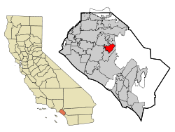
Coordinates: 33°45′54″N 117°47′57″W / 33.765°N 117.79917°WCoordinates: 33°45′54″N 117°47′57″W / 33.765°N 117.79917°W Country  United States
State  California
County Orange Area[1] – Total 6.673 sq mi (17.284 km2) – Land 6.673 sq mi (17.284 km2) – Water 0 sq mi (0 km2) 0% Population (2010) – Total 24,917 – Density 3,734/sq mi (1,441.6/km2) Time zone PST (UTC-8) – Summer (DST) PDT (UTC-7) ZIP code 92705 Area code(s) 714 FIPS code 06-80868 North Tustin[2] is a census-designated place and unincorporated community in Orange County, California. The population was 24,917 at the 2010 census, up from 24,044 at the 2000 census. It is Orange County's largest Census Designated place. It is not located in the city limits of Tustin, using Santa Ana as its proper mailing addresses according to the USPS, and a 92705 ZIP Code. The name was changed from Tustin Foothills in 2005.[3]
Contents
Communities within North Tustin
North Tustin is a large census area north of the city of Tustin and include separate unincorporated communities of Cowan Heights, East Tustin, Lemon Heights, North Tustin, Panorama Heights, and Red Hill. The Foothill Communities Association is a nonprofit corporation that has strived since the 1960s to preserve the highly valued living environment in these unincorporated communities.
Geography
North Tustin is located at 33°45′54″N 117°47′57″W / 33.765°N 117.79917°W (33.765117, -117.799268).[4]
According to the United States Census Bureau, the CDP has a total area of 6.7 square miles (17 km2), all of it land.
North Tustin is bordered by the city of Tustin on the west, south, and east, and by the city of Orange on the north.
Demographics
Historical populations Census Pop. %± 1970 26,598 — 1980 26,174 −1.6% 1990 24,358 −6.9% 2000 24,044 −1.3% 2010 24,917 3.6% source:[5][6] 2010
The 2010 United States Census[7] reported that North Tustin had a population of 24,917. The population density was 3,733.7 people per square mile (1,441.6/km²). The racial makeup of North Tustin was 20,836 (83.6%) White, 148 (0.6%) African American, 104 (0.4%) Native American, 1,994 (8.0%) Asian, 52 (0.2%) Pacific Islander, 908 (3.6%) from other races, and 875 (3.5%) from two or more races. Hispanic or Latino of any race were 3,260 persons (13.1%).
The Census reported that 24,726 people (99.2% of the population) lived in households, 161 (0.6%) lived in non-institutionalized group quarters, and 30 (0.1%) were institutionalized.
There were 8,580 households, out of which 3,036 (35.4%) had children under the age of 18 living in them, 5,971 (69.6%) were opposite-sex married couples living together, 685 (8.0%) had a female householder with no husband present, 310 (3.6%) had a male householder with no wife present. There were 200 (2.3%) unmarried opposite-sex partnerships, and 69 (0.8%) same-sex married couples or partnerships. 1,276 households (14.9%) were made up of individuals and 764 (8.9%) had someone living alone who was 65 years of age or older. The average household size was 2.88. There were 6,966 families (81.2% of all households); the average family size was 3.19.
The population was spread out with 5,857 people (23.5%) under the age of 18, 1,709 people (6.9%) aged 18 to 24, 4,613 people (18.5%) aged 25 to 44, 7,979 people (32.0%) aged 45 to 64, and 4,759 people (19.1%) who were 65 years of age or older. The median age was 45.6 years. For every 100 females there were 96.3 males. For every 100 females age 18 and over, there were 94.0 males.
There were 8,866 housing units at an average density of 1,328.5 per square mile (513.0/km²), of which 7,676 (89.5%) were owner-occupied, and 904 (10.5%) were occupied by renters. The homeowner vacancy rate was 0.9%; the rental vacancy rate was 3.4%. 22,095 people (88.7% of the population) lived in owner-occupied housing units and 2,631 people (10.6%) lived in rental housing units.
2000
As of the census[8] of 2000, there were 24,044 people, 8,269 households, and 6,945 families residing in the CDP. The population density was 3,590.5 people per square mile (1,385.6/km²). There were 8,417 housing units at an average density of 1,256.9 per square mile (485.0/km²). The racial makeup of the CDP was 86.80% White, 0.56% African American, 0.36% Native American, 7.05% Asian, 0.13% Pacific Islander, 2.62% from other races, and 2.48% from two or more races. Hispanic or Latino of any race were 8.47% of the population.
There were 8,269 households out of which 34.9% had children under the age of 18 living with them, 74.2% were married couples living together, 7.0% had a female householder with no husband present, and 16.0% were non-families. 11.9% of all households were made up of individuals and 6.7% had someone living alone who was 65 years of age or older. The average household size was 2.89 and the average family size was 3.12.
In the CDP the population was spread out with 25.0% under the age of 18, 5.4% from 18 to 24, 24.6% from 25 to 44, 28.2% from 45 to 64, and 16.8% who were 65 years of age or older. The median age was 42 years. For every 100 females there were 96.6 males. For every 100 females age 18 and over, there were 94.4 males.
The median income for a household in the CDP was $96,230, and the median income for a family was $103,257. Males had a median income of $71,688 versus $42,785 for females. The per capita income for the CDP was $42,656. About 2.2% of families and 3.3% of the population were below the poverty line, including 3.2% of those under age 18 and 1.9% of those age 65 or over.
Politics
In the state legislature North Tustin is located in the 33rd Senate District, represented by Republican Dick Ackerman, and in the 70th and 71st Assembly District, represented by Republicans Chuck DeVore and Todd Spitzer respectively. Federally, North Tustin is located in California's 48th congressional district, which has a Cook PVI of R +8[9] and is represented by Republican John Campbell.
Education
Primary and secondary education is overseen by the Tustin Unified School District, which also serves the incorporated City of Tustin. It has one of the highest accelerated learning percentages in the US.
See also
References
- ^ U.S. Census
- ^ North Tustin detailed profile
- ^ U.S. Census Geographic Change Notes: California
- ^ "US Gazetteer files: 2010, 2000, and 1990". United States Census Bureau. 2011-02-12. http://www.census.gov/geo/www/gazetteer/gazette.html. Retrieved 2011-04-23.
- ^ "CENSUS OF POPULATION AND HOUSING (1790-2000)". U.S. Census Bureau. http://www.census.gov/prod/www/abs/decennial/index.html. Retrieved 2010-07-17.
- ^ Census figures from 1980 to 2000 enumerated as Tustin Foothills. Census figure from 1970 returned as Tustin-Foothills.
- ^ All data are derived from the United States Census Bureau reports from the 2010 United States Census, and are accessible on-line here. The data on unmarried partnerships and same-sex married couples are from the Census report DEC_10_SF1_PCT15. All other housing and population data are from Census report DEC_10_DP_DPDP1. Both reports are viewable online or downloadable in a zip file containing a comma-delimited data file. The area data, from which densities are calculated, are available on-line here. Percentage totals may not add to 100% due to rounding. The Census Bureau defines families as a household containing one or more people related to the householder by birth, opposite-sex marriage, or adoption. People living in group quarters are tabulated by the Census Bureau as neither owners nor renters. For further details, see the text files accompanying the data files containing the Census reports mentioned above.
- ^ "American FactFinder". United States Census Bureau. http://factfinder.census.gov. Retrieved 2008-01-31.
- ^ "Will Gerrymandered Districts Stem the Wave of Voter Unrest?". Campaign Legal Center Blog. http://www.clcblog.org/blog_item-85.html. Retrieved 2008-02-10.
Municipalities and communities of Orange County, California Cities Aliso Viejo | Anaheim | Brea | Buena Park | Costa Mesa | Cypress | Dana Point | Fountain Valley | Fullerton | Garden Grove | Huntington Beach | Irvine | La Habra | La Palma | Laguna Beach | Laguna Hills | Laguna Niguel | Laguna Woods | Lake Forest | Los Alamitos | Mission Viejo | Newport Beach | Orange | Placentia | Rancho Santa Margarita | San Clemente | San Juan Capistrano | Santa Ana | Seal Beach | Stanton | Tustin | Villa Park | Westminster | Yorba Linda
CDPs Coto de Caza | Ladera Ranch | Las Flores | Midway City | North Tustin | Rossmoor | Sunset Beach
Unincorporated
communitiesAnaheim Island | Modjeska Canyon | Orange Park Acres | Santa Ana Heights | Santiago Canyon | Silverado | Trabuco Canyon
Categories:- Census-designated places in Orange County, California
- Unincorporated communities in California


Wikimedia Foundation. 2010.