- Dana Point, California
-
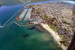
City of Dana Point — City — Aerial view of Dana Point 
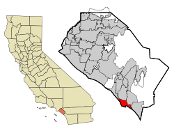
SealLocation of Dana Point within Orange County, California. Coordinates: 33°28′2″N 117°41′53″W / 33.46722°N 117.69806°WCoordinates: 33°28′2″N 117°41′53″W / 33.46722°N 117.69806°W Country  United States
State  California
County Orange Incorporation 1989 Government - Mayor Scott Schoeffel Area[1] - Total 29.484 sq mi (76.364 km2) - Land 6.497 sq mi (16.828 km2) - Water 22.987 sq mi (59.536 km2) 77.96% Elevation 144 ft (44 m) Population (2010) - Total 33,351 - Density 1,131.1/sq mi (436.7/km2) Time zone PST (UTC-8) - Summer (DST) PDT (UTC-7) ZIP codes 92624, 92629 Area code(s) 949 FIPS code 06-17946 GNIS feature ID 1656474 Website http://www.danapoint.org/ Dana Point is a city located in southern Orange County, California. The population was 33,351 at the 2010 census. It has one of the few harbors along the Orange County coast, and with ready access via State Route 1, it is a popular local destination for surfing and was home to a legendary surf break called Killer Dana.
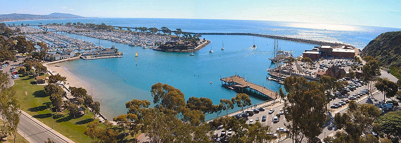
The city was named after the headland of Dana Point, which was in turn named for Richard Henry Dana, Jr., author of Two Years Before the Mast, which included a description of the area. Dana described the locale, including neighboring San Juan Capistrano, as "the only romantic spot on the coast".[2] Although Dana described the anchorage as poor, it is now a developed harbor and contains a replica of his ship, the Pilgrim. The Pilgrim is used as a classroom by the Ocean Institute, which is located at the harbor. This area is designated California Historical Landmark #189.
One of the very few known specimens of the megamouth shark was caught off Dana Point in 1990.
Producers of Laguna Beach: The Real Orange County scouted Dana Point and numerous other affluent Southern California rich towns and beaches including San Marino, Palos Verdes, Carlsbad,and Malibu, before deciding to locate the show in Laguna Beach.
Contents
History
Dana Point
In 1923, Los Angeles Times publisher Harry Chandler and General M.H. Sherman, Director of the Pacific Electric Railway Company, created a major real estate group to develop what is known today as the Hollywood Hills, Sidney H. Woodruff, already a prominent Los Angeles homebuilder, was hired to lead the project. In 1926, Woodruff, Chandler, and Sherman created the Dana Point Syndicate. They invited other heavy hitters, company presidents, movie producers, and real estate investors, to join them in purchasing 1,388 acres (5.6 km2) of land, some of which includes the "Headlands" of today. Promising tree-lined, paved streets, electricity, telephones, sidewalks, water mains, storm drains, sewers, and other amenities, Woodruff built 35 homes and a number of commercial buildings.
Most of these "Woodruff" houses are concentrated in a Dana Point's historic core, also called Lantern Village (currently about 12,000 residents). The streets are named after the different colored lanterns, street of the Violet Lantern, Blue Lantern, etc. (colored lanterns were used by ships 200 years ago to advertise their fares when pulled into the Dana Point natural harbor). His crowning structure was to be the Dana Point Inn, a Mediterranean-like resort hotel. After a celebratory groundbreaking in 1930, a three-story foundation was poured and a 135-foot (41 m) elevator shaft was dug. Unfortunately, the Depression caused construction to halt. Although Woodruff continuously sought financial support through the years, this project was abandoned in 1939. Subsequently, he sold the remaining holdings of the Dana Point Syndicate. Thirty-four of the original Woodruff residences are still occupied.
Capistrano Beach
In 1928, a corporate entity of the American industrial giant Edward Doheny, who had built his fortune in oil production in Southern California and Mexico, purchased a number of lots in Capistrano Beach. Doheny's son, Ned, formed a development company, the Capistrano Beach Company, which included his wife's twin brothers, Clark and Warren Smith and Luther Eldridge, a contractor, to build a community of Spanish style houses. According to Dana Point historians Baum and Burnes,* Eldridge favored two dominant characteristics in his homes, a typically Spanish roof line and the use of large ceiling beams in the houses' main rooms. The roofline, covered with red ceramic tiles, incorporated a low-pitched gable, spreading out to one short and one long roof. The ceiling beams were stenciled artwork painted by artist Alex Meston. Eldridge was able to complete the original Doheny family house on the bluffs, four houses on the beach, and 18 other homes scattered throughout the area before tragedy struck the ambitious project. Edward Doheny was preparing for his criminal trial for bribery in the Teapot Dome Scandal, and on February 16, 1929, Ned Doheny and, Hugh Plunkett, his friend and secretary, who were to testify in the trial, were killed in a murder that still remains unsolved. In 1931, as a memorial to Ned, Petroleum Securities Company, Doheny's family-owned business, made a gift of 41.4 acres (168,000 m2) to the State of California, which is now Doheny State Park. The unimproved Capistrano Beach properties passed back to Edward Doheny, and, upon his death in 1935, to his wife and heirs. By 1944, all of the properties had been sold to private parties.
The Doheny family also funded the building of the what was then called St. Edward's Chapel in Capistrano Beach. The Chapel soon grew, received canonical status as a parish, and moved to its current bluff-top location in Dana Point, overlooking Doheny State Beach.
Geography
According to the United States Census Bureau, the city has a total area of 29.5 square miles (76 km2). 6.5 square miles (17 km2) of it is land and 23.0 square miles (60 km2) of it (77.96%) is water.
Dana Point headlands are a prominent feature in Orange County geography and after years of controversy,[3] are currently being developed as a 118-house gated community.
However 68 acres (280,000 m2) of the site is open to the public and features a nature center and walking trails exhibiting "lost" plants of the Southern California coast. Views on a clear day extend to Catalina Island and La Jolla in San Diego county. link Dana Point Headlands

Laguna Beach Laguna Niguel San Juan Capistrano 
Pacific Ocean 
San Juan Capistrano  Dana Point

Pacific Ocean Pacific Ocean San Clemente Climate
Dana Point enjoys a mild climate where temperatures tend to average around the 60's. The warmest month of the year is August with an average temperature of 79 degrees Fahrenheit. The coldest month is December with an average minimum temperature of 44 degrees Fahrenheit.[citation needed]
Demographics
2010
The 2010 United States Census[4] reported that Dana Point had a population of 33,351. The population density was 1,131.1 people per square mile (436.7/km²). The racial makeup of Dana Point was 28,701 (86.1%) White, 294 (0.9%) African American, 229 (0.7%) Native American, 1,064 (3.2%) Asian, 37 (0.1%) Pacific Islander, 1,952 (5.9%) from other races, and 1,074 (3.2%) from two or more races. Hispanic or Latino of any race were 5,662 persons (17.0%).
The Census reported that 33,110 people (99.3% of the population) lived in households, 160 (0.5%) lived in non-institutionalized group quarters, and 81 (0.2%) were institutionalized.
There were 14,182 households, out of which 3,459 (24.4%) had children under the age of 18 living in them, 6,902 (48.7%) were opposite-sex married couples living together, 1,232 (8.7%) had a female householder with no husband present, 645 (4.5%) had a male householder with no wife present. There were 780 (5.5%) unmarried opposite-sex partnerships, and 137 (1.0%) same-sex married couples or partnerships. 4,012 households (28.3%) were made up of individuals and 1,406 (9.9%) had someone living alone who was 65 years of age or older. The average household size was 2.33. There were 8,779 families (61.9% of all households); the average family size was 2.85.
The population was spread out with 5,959 people (17.9%) under the age of 18, 2,522 people (7.6%) aged 18 to 24, 8,261 people (24.8%) aged 25 to 44, 10,927 people (32.8%) aged 45 to 64, and 5,682 people (17.0%) who were 65 years of age or older. The median age was 44.8 years. For every 100 females there were 98.2 males. For every 100 females age 18 and over, there were 96.9 males.
There were 15,938 housing units at an average density of 540.6 per square mile (208.7/km²), of which 8,314 (58.6%) were owner-occupied, and 5,868 (41.4%) were occupied by renters. The homeowner vacancy rate was 2.0%; the rental vacancy rate was 7.0%. 19,419 people (58.2% of the population) lived in owner-occupied housing units and 13,691 people (41.1%) lived in rental housing units.
2000
As of the census[5] of 2000, there were 35,110 people, 14,456 households, and 9,280 families residing in the city. The population density was 5,290.1 inhabitants per square mile (2,041.6/km²). There were 15,682 housing units at an average density of 2,362.8 per square mile (911.9/km²). The racial makeup of the city was 87.25% White, 0.82% Black or African American, 0.57% Native American, 2.52% Asian, 0.10% Pacific Islander, 5.92% from other races, and 2.81% from two or more races. 15.49% of the population were Hispanic or Latino of any race.
There were 14,456 households out of which 26.2% had children under the age of 18 living with them, 51.4% were married couples living together, 8.8% had a female householder with no husband present, and 35.8% were non-families. 26.0% of all households were made up of individuals and 7.1% had someone living alone who was 65 years of age or older. The average household size was 2.41 and the average family size was 2.90.
In the city the population was spread out with 20.6% under the age of 18, 7.1% from 18 to 24, 31.4% from 25 to 44, 28.0% from 45 to 64, and 13.0% who were 65 years of age or older. The median age was 40 years. For every 100 females there were 100.1 males. For every 100 females age 18 and over, there were 98.4 males.
The median income for a household in the city was $63,043, and the median income for a family was $73,373 (these figures had risen to $81,665 and $97,826 respectively as of a 2007 estimate[6]). Males had a median income of $52,159 versus $38,902 for females. The per capita income for the city was $37,938. About 3.4% of families and 6.7% of the population were below the poverty line, including 6.8% of those under age 18 and 5.3% of those age 65 or over.
In 2010 Dana Point had a population of 33,351. The median age was 44.8 years. The racial and ethnic composition of the population was 76.4% non-Hispanic white, 0.9% black or African American, 0.7% Native American, 3.2% Asian, 0.1% Pacific Islander, 0.2% non-Hispanic of some other race, 3.2% reporting two or more races and 17.0% Hispanic or Latino. Mexicans made up 13.2% of the population.[7]
Annual cultural events
Dana Point has held a Festival of Whales since 1972. This celebration is held over two weekends in March.[8]
The Tall Ships Festival is held in September. It is considered the largest annual gathering of its kind on the West Coast of the United States.[9]
Dana Point has hosted the Dana Point Concours d'Elegance since 2008. The event is located on the Monarch Beach Golf Links and supports various charities.
The Dana Point Grand Prix is an annual criterium bike race overlooking Dana Point Harbor. The course winds its way through downtown Dana Point into Heritage Park and the adjoining residential community with spectacular viewing for fans and spectators before finishing on a long straightaway on PCH. http://www.danapointgrandprix.com/
Government
In the state legislature Dana Point is located in the 35th Senate District, represented by Republican Tom Harman, and in the 73rd Assembly District, represented by Republican Diane Harkey. Federally, Dana Point is located in California's 48th congressional district, which has a Cook PVI of R +8[10] and is represented by Republican John Campbell.
Education
The city is served by Capistrano Unified School District. It includes Dana Hills High School, one of the oldest in the area which opened in 1972.
Emergency services
Fire protection in Dana Point is provided by the Orange County Fire Authority with ambulance service by Doctor's Ambulance. Law enforcement is provided by the Orange County Sheriff's Department. Year round marine safety services are provided by U.S. Ocean Safety Lifeguards on county beaches and California State Lifeguards on state beaches.
See also
References
- ^ U.S. Census
- ^ Dana, Jr., Richard Henry (1912). Two Years Before the Mast. D. Appleton. p. 147. http://books.google.com/books?id=SXQaAAAAYAAJ&dq=two+years+before+the+mast&printsec=frontcover#v=onepage&q&f=false. Retrieved 1 July 2010.
- ^ http://www.surfingthemag.com/news/surfing-pulse/strands-061305-dana-point/ surfingthemag.com
- ^ All data are derived from the United States Census Bureau reports from the 2010 United States Census, and are accessible on-line here. The data on unmarried partnerships and same-sex married couples are from the Census report DEC_10_SF1_PCT15. All other housing and population data are from Census report DEC_10_DP_DPDP1. Both reports are viewable online or downloadable in a zip file containing a comma-delimited data file. The area data, from which densities are calculated, are available on-line here. Percentage totals may not add to 100% due to rounding. The Census Bureau defines families as a household containing one or more people related to the householder by birth, opposite-sex marriage, or adoption. People living in group quarters are tabulated by the Census Bureau as neither owners nor renters. For further details, see the text files accompanying the data files containing the Census reports mentioned above.
- ^ "American FactFinder". United States Census Bureau. http://factfinder.census.gov. Retrieved 2008-01-31.
- ^ http://factfinder.census.gov/servlet/ACSSAFFFacts?_event=Search&geo_id=16000US0617750&_geoContext=01000US%7C04000US06%7C16000US0617750&_street=&_county=dana+point&_cityTown=dana+point&_state=04000US06&_zip=&_lang=en&_sse=on&ActiveGeoDiv=geoSelect&_useEV=&pctxt=fph&pgsl=160&_submenuId=factsheet_1&ds_name=ACS_2007_3YR_SAFF&_ci_nbr=null&qr_name=null®=null%3Anull&_keyword=&_industry=
- ^ Census General Population and Housing Characteristics report for Dana Point, 2010
- ^ Daines, Chris (March 3, 2009). "Festival of Whales coasts into Dana Point". The Orange County Register. http://www.ocregister.com/articles/whales-festival-point-2324011-dana-whale. Retrieved March 6, 2009.
- ^ "Tall Ships Festival". The Orange County Register: pp. Show 1. 2008-09-05.
- ^ "Will Gerrymandered Districts Stem the Wave of Voter Unrest?". Campaign Legal Center Blog. http://www.clcblog.org/blog_item-85.html. Retrieved 2008-02-10.
- Stillman, Deanne (January 17, 1999). "Sunshine States - Legends of the Surf at Dana Point". The New York Times. http://query.nytimes.com/gst/fullpage.html?sec=travel&res=9E00E5D81731F934A25752C0A96F958260. Retrieved February 13, 2007.
External links
- City of Dana Point website
- Dana Point Visitors Bureau
- Dana Point Times, local newspaper
- Dana Point Chamber of Commerce
- Dana Point Harbor, Recreational Area
Municipalities and communities of Orange County, California County seat: Santa Ana Cities Aliso Viejo | Anaheim | Brea | Buena Park | Costa Mesa | Cypress | Dana Point | Fountain Valley | Fullerton | Garden Grove | Huntington Beach | Irvine | La Habra | La Palma | Laguna Beach | Laguna Hills | Laguna Niguel | Laguna Woods | Lake Forest | Los Alamitos | Mission Viejo | Newport Beach | Orange | Placentia | Rancho Santa Margarita | San Clemente | San Juan Capistrano | Santa Ana | Seal Beach | Stanton | Tustin | Villa Park | Westminster | Yorba Linda
CDPs Unincorporated
communitiesAnaheim Island | Modjeska Canyon | Orange Park Acres | Santa Ana Heights | Santiago Canyon | Silverado | Trabuco Canyon
Categories:- Cities in Southern California
- California Historical Landmarks
- Cities in Orange County, California
- Populated coastal places in California
- Populated places established in 1926
- Incorporated cities and towns in California
Wikimedia Foundation. 2010.


