- Fountain Valley, California
:"This article is for the city in California. For the valley and rural community in British Columbia, Canada, see
Fountain Valley (British Columbia) .Infobox Settlement
official_name = City of Fountain Valley, California
settlement_type =City
motto = "A Nice Place to Live"
imagesize =
image_caption =
image_
imagesize =
image_caption =
image_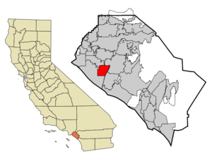
mapsize = 250x200px
map_caption = Location of Fountain Valley withinOrange County, California .
mapsize1 =
map_caption1 =
subdivision_type = Country
subdivision_type1 = State
subdivision_type2 = County
subdivision_name =United States
subdivision_name1 =California
subdivision_name2 = Orange
government_type =
leader_title =Mayor
leader_name = John Collins
established_date =
area_magnitude = 1 E8
area_total_km2 = 23.1
area_land_km2 = 23.1
area_water_km2 = 0.0
population_footnotes = cite web | date = May 1, 2006 | url = http://www.dof.ca.gov/HTML/DEMOGRAP/ReportsPapers/Estimates/E1/documents/e-1press.pdf | title = E-1 Population Estimates for Cities, Counties and the State with Annual Percent Change — January 1, 2005 and 2006 | format = PDF | publisher = California Department of Finance | accessmonthday=November 16 | accessyear = 2006]
population_as_of = 2007
population_total = 57741
population_density_km2 = 2859.5
timezone = PST
utc_offset = -8
timezone_DST = PDT
utc_offset_DST = -7
latitude = 33°42'31" N
longitude = 117°57'23" W
latd = 33 |latm = 42 |lats = 31 |latNS = N
longd = 117 |longm = 57 |longs = 23 |longEW = W
area_total_sq_mi = 8.9
area_land_sq_mi = 8.9
area_water_sq_mi = 0.0
elevation_m = 10
elevation_ft = 33
website = http://www.fountainvalley.org
postal_code_type =ZIP code s
postal_code = 92708, 92728
area_code = 714
blank_name = FIPS code
blank_info = 06-25380
blank1_name = GNIS feature ID
blank1_info = 1652712Fountain Valley is a city in Orange County,
California ,United States . The population was 57,741 at the 2007 census. A classic bedroom community, Fountain Valley is a safe, middle-class, residential area.History
The area encompassing Fountain Valley was originally inhabited by the
Tongva people. European settlement of the area began whenManuel Nieto was granted the land forRancho Los Nietos , which encompassed over convert|300000|acre|km2, including present-day Fountain Valley. Control of the land was subsequently transferred toMexico upon independence fromSpain , and then to theUnited States as part of theTreaty of Guadalupe Hidalgo .The city was incorporated in 1957, before which it was known as Talbert (also as Gospel Swamps by residents). The name of Fountain Valley refers to the very high
water table in the area at the time the name was chosen, and the many corresponding artesian wells in the area. Early settlers constructed drainage canals to make the land usable for agriculture, which remained the dominant use of land until the 1960s, when construction of large housing tracts accelerated. History of the City of Fountain Valley, www.fountainvalley.org]Geography
Fountain Valley is located at coor dms|33|42|31|N|117|57|23|W|city (33.708618, -117.956295)GR|1. The elevation of the city is approximately twenty feet above sea level, slightly lower than surrounding areas. This can be seen first-hand on the southwest end of the city where westbound streets rise up about twenty-five feet after crossing into Huntington Beach.
It is located southwest and northeast of the
San Diego Freeway (405), which diagonally bisects the city, and is surrounded by Huntington Beach, Westminster, Garden Grove, Santa Ana, and Costa Mesa. Its eastern border is theSanta Ana River .According to the
United States Census Bureau , the city has a total area of 23.1 km² (8.9 mi²). 23.1 km² (8.9 mi²) of it is land and 0.11% is water.Demographics
As of the
census GR|2 of 2007, there were 57,741 people, 18,162 households, and 14,220 families residing in the city. Thepopulation density was 2,382.4/km² (6,167.8/mi²). There were 18,473 housing units at an average density of 800.5/km² (2,072.4/mi²). The racial makeup of the city was 64.02% White, 1.11% Black or African American, 0.46% American Indian or Alaskan Native, 25.76% Asian, 0.40% Native Hawaiian or other Pacific Islander, 3.95% from other races, and 4.30% from two or more races. 10.68% of the population were Hispanic or Latino of any race.There were 18,162 households out of which 34.3% had children under the age of 18 living with them, 63.4% were married couples living together, 10.5% had a female householder with no husband present, and 21.7% were non-families. 16.0% of all households were made up of individuals and 5.5% had someone living alone who was 65 years of age or older. The average household size was 3.00 and the average family size was 3.35. More than 1/3 of all the housing units in the city are those other than single-family homes, such as
condominiums orapartments .In the city the population was spread out with 23.5% under the age of 18, 7.9% from 18 to 24, 30.1% from 25 to 44, 27.2% from 45 to 64, and 11.3% who were 65 years of age or older. The median age was 38 years. For every 100 females there were 95.6 males. For every 100 females age 18 and over, there were 93.0 males.
The median income for a household in the city was $69,734, and the median income for a family was $74,502. Males had a median income of $50,399 versus $36,089 for females. The
per capita income for the city was $26,521. About 3.0% of families and 4.3% of the population were below thepoverty line , including 4.7% of those under age 18 and 6.0% of those age 65 or over.Politics
In the state legislature Fountain Valley is located in the 35th Senate District, represented by Republican
Tom Harman , and in the 68th Assembly District, represented by RepublicanVan Tran . Federally, Fountain Valley is located inCalifornia's 46th congressional district , which has a Cook PVI of R +6 [cite web | title = Will Gerrymandered Districts Stem the Wave of Voter Unrest? | publisher = Campaign Legal Center Blog | url=http://www.clcblog.org/blog_item-85.html | accessdate = 2008-02-10] and is represented by RepublicanDana Rohrabacher .Community amenities
As a
suburb an city, most of Fountain Valley's residents commute to work in other urban centers. However, unlike most commuter towns, Fountain Valley is not considered a rural or "exurban" city, as it is part Orange County's sprawling developed landscape. In recent years, Fountain Valley has seen an increase in workers commuting "to" the city, with the growth of an office/commercial center near the Santa Ana River.Fountain Valley is home to
Mile Square Regional Park , a 640 acre (2.6 km²) park containing two lakes, three 18-hole golf courses, playing fields, picnic shelters, and a twenty-acre urban nature area planted withCalifornia native plants , a 55 acre (223,000 m²) recreation center with tennis courts, basketball courts, racquetball courts, a gymnasium, and the Kingston Boys & Girls Club; also a community center and a new senior center that opened in June, 2005. A major redevelopment of the recreation center and sports fields is under construction as of December 2007.Fire protection and emergency medical services are provided by two stations of the
Fountain Valley Fire Department . Law enforcement is provided by theFountain Valley Police Department . Ambulance service is provided byCare Ambulance Service .The Orange County Sanitation District's primary plant is located in Fountain Valley next to the Santa Ana River. The agency is the third-largest sanitation district in the western United States. This location is also home to the agency's administrative offices, as well as the offices of the Municipal Water District of Orange County, a member of the
Metropolitan Water District of Southern California Fountain Valley has two fully accredited major medical centers: the
Fountain Valley Regional Hospital with 400 beds available, and Orange Coast Memorial Hospital with 230 beds and a medical clinic. Orange Coast Memorial recently announced plans for a six-story outpatient center to be added. The project was initially met by some opposition due to its height and location next to residences, but was eventually approved unanimously by the city council.The city also has 18 churches, one Reform
synagogue , a mosque and a public library.Fountain Valley has its own newspaper, the Fountain Valley View, operated by the
Orange County Register .Education
There are three
high school s, threemiddle school s, nineelementary school s, one K-12 school, and two K-8 schools. However, some students who live in the city of Fountain Valley actually attend schools in other cities.Fountain Valley is also home to
Coastline Community College and a campus of theUniversity of Phoenix . High school students from Fountain Valley often go on to attendOrange Coast College orGolden West College , located nearby in the cities of Costa Mesa and Huntington Beach, respectively.High schools in
Huntington Beach Union High School District
*Fountain Valley High School
*Valley Vista High School, California High schools in
Garden Grove Unified School District
*Los Amigos High School Middle schools in
Fountain Valley School District
*Fulton Middle School
*Masuda Middle School -this school is named in honor of Kazuo Masuda
*Talbert Middle School Middle schools inOcean View Middle School District
*Vista View Middle School Elementary schools in Garden Grove Unified School District
*Allen Elementary School
*Monroe Elementary School
*Northcutt Elementary School Elementary schools in Fountain Valley School District
*Courreges Elementary School
*Cox Elementary School
*Gisler Elementary School
*Moiola Elementary School (K-8)
*Plavan Elementary School
*Tamura Elementary School
*Newland Elementary School Private schools
*Carden School of Fountain Valley (K-8)
*First Southern Baptist Christian School (K-12)Business
Fountain Valley has blooming commercial innovations but little industrial production of its own. The remaining agricultural production consists of several fields of strawberries or other small crops.
Fountain Valley is home to the national headquarters of
Hyundai Motor Company andD-Link Corporation, the global headquarters of memory chip manufacturerKingston Technologies , and the corporate headquarters of Surefire, LLC, maker of military and commercial flashlights. The commercial area along Newhope Street is also home to offices for companies such asD-Link ,Starbucks , Satura and the Orange County Register. There are also a limited number of light industrial companies in this area.The increasing commercial growth can be evidenced by the frequent rush-hour traffic bottlenecks on the I-405 through Fountain Valley.
Transportation
In addition to the I-405 freeway which bisects the city, Fountain Valley is served by several bus lines operated by the Orange County Transportation Authority. Bus routes 33, 35, 37, 70, 72, 74, and 172 cover the city's major streets.
Most of the major roads are equipped with
bicycle lanes, especially around Mile Square Park, which offers wide bike paths along the major streets that mark its boundary. Dedicated bike paths along the Santa Ana River run from the city of Corona to thePacific Ocean .References
External links
* [http://www.fountainvalley.org/ City of Fountain Valley] official site
*Fountain Valley [http://www.fountainvalley.org/concierge/html/Content001.asp?pagetype=Content001&pageid=656&AppID=18&pagename=FV_city%20information&pagetypeid=19&folder=Fountain&theme=trueblue&menu=Gold&kioskid=&variable1= Community Economic Profile]
Wikimedia Foundation. 2010.