- Quebec Autoroute 40
-
Autoroute 40
Autoroute Félix-Leclerc
Metropolitan Expressway
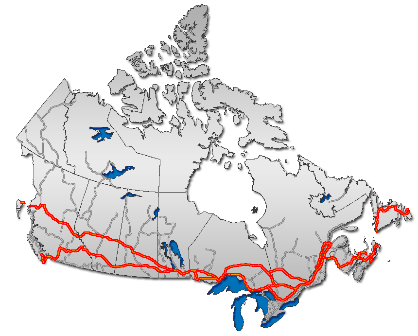
Trans-Canada Highway
Route information Maintained by Transports Québec Length: 347 km[1][2] (215.6 mi) Existed: 1959 [1] – present Major junctions West end:  Highway 417 near Pointe-Fortune, Quebec
 A-540 in Vaudreuil-Dorion

 A-13 and A-520 in Dorval


 A-15, A-19, A-25 in Montreal
 A-640 in Charlemagne
 A-31 in Lavaltrie
 A-55 in Trois-Rivières


 A-73, A-540, A-573, A-740 in Quebec City
East end: 
 Route 138/368 near Boischatel
Location Major cities: Vaudreuil-Dorion, Montreal, Charlemagne, Repentigny, Trois-Rivières, Quebec City Highway system ←  A-35
A-35A-50  →
→

Autoroute 40 (officially called Autoroute Félix-Leclerc outside Montreal and Metropolitan Autoroute/Autoroute Métropolitaine within Montreal) is a major highway on the north shore of the St. Lawrence River in Quebec, Canada. It is one of the two main connections between Montreal and Quebec City (the other being Autoroute 20 on the south shore of the St. Lawrence). Autoroute 40 is currently 347 km (215.6 mi) long.
The western terminus of Autoroute 40 is located at the Ontario–Quebec border, where it continues as Highway 417 towards Ottawa; the eastern terminus is in Boischatel, where it transitions into Route 138 at the end of the freeway.
Two sections of Autoroute 40 were not part of the original plans: The original intention was to bypass Trois-Rivières to the north (the existing A-40 through downtown would have been Autoroute 755 and the concurrency with Autoroute 55 would have been simply A-55). In addition, a different route was originally planned around Sainte-Foy (now in the west end of Quebec City) south of Jean Lesage International Airport (the existing 12 km segment of Autoroute 40 between St-Augustin and Autoroute 73 would have been the western end of Autoroute 440, thus explaining the exit numbering starting at 12). While the right-of-ways of both bypasses still exist and may still be developed in the future as congestion increases, there are no immediate plans to renew construction.
Some discussion of eastward extensions of A-40 into the Charlevoix region and beyond have taken place, most likely to Route 360 in Beaupré or even as far as Route 362 in La Malbaie since tourism in the region is increasing; however, that appears unlikely in the short term.
The portion of Autoroute 40 from the Ontario border to Autoroute 25 is part of the Trans-Canada Highway.
In 1997, the highway (apart from the portion served by the Metropolitan Autoroute) was renamed Autoroute Félix-Leclerc after the late Quebec artist and political activist Félix Leclerc.
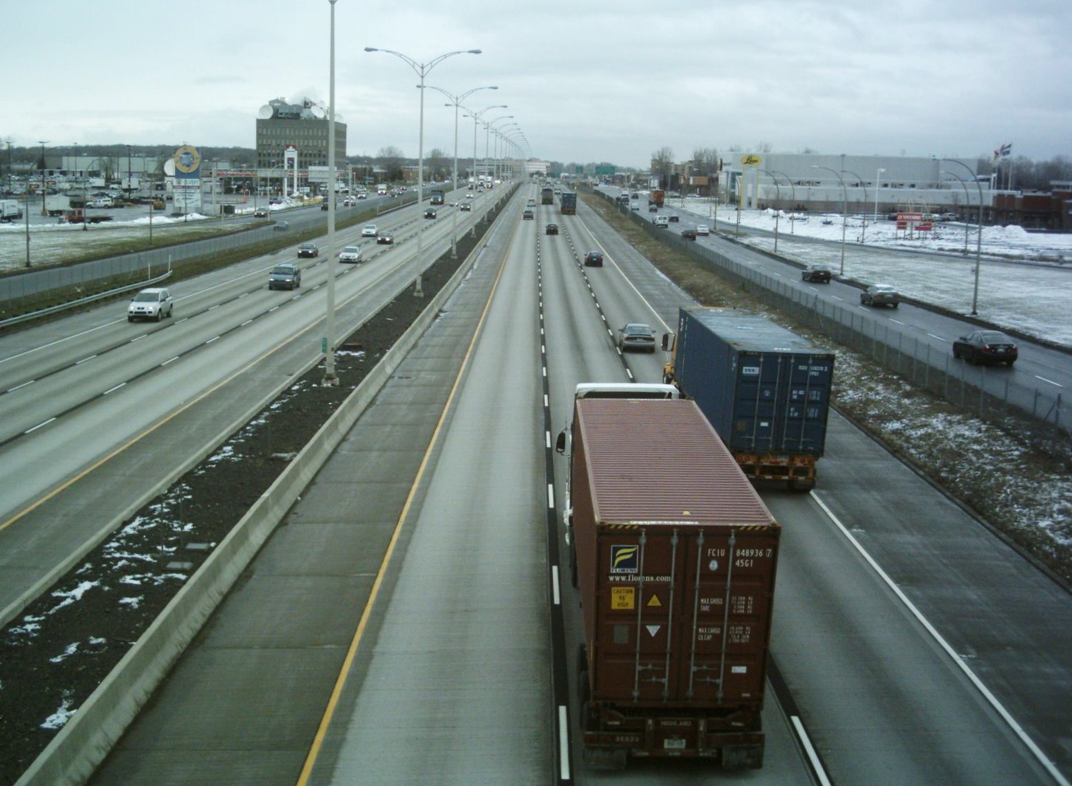
Its Metropolitan Autoroute portion in Montreal is the busiest highway in Quebec, as well as the second busiest in Canada after Highway 401 in Toronto.
Of historical note, a 25 km (16 mi) stretch of the highway in Pointe-Claire (from roughly St. John's Boulevard near Fairview Pointe-Claire Shopping Centre to St. Charles Boulevard) was used during the 1976 Summer Olympics for the men's road team time trial cycling race.[3]
Contents
Exit list
Location # Destinations Notes Pointe-Fortune 1  Route 342 – Pointe-Fortune
Eastbound Exit 1 accesses Route 342 via Montée Jansson / Concession Road 1 and Montée La Grande (Prescott-Russell County Road 14). 2 Montée Wilson – Pointe-Fortune Rigaud 6 Montée Baie Saint-Thomas 9 Route 342 – Rigaud12 Route 34217  Route 201 (Montée Lavigne) – Salaberry-de-Valleyfield
Saint-Lazare 22 Hudson, Saint-Lazare Vaudreuil-Dorion 26 Route 342 – Hudson, Saint-Lazare32 

 A-540 to A-20 / Highway 401 – Salaberry-de-Valleyfield, Toronto
35 Avenue Saint-Charles – Vaudreuil-Dorion, Vaudreuil-sur-le-Lac 36 Chemin Dumberry, Chemin des Chenaux Westbound exit and eastbound entrance Senneville 40 Montreal Westbound exit and eastbound entrance (U-turn ramp) Sainte-Anne-de-Bellevue 41 Sainte-Anne-de-Bellevue, Île-Perrot 44 Boulevard Morgan Kirkland 49 Chemin Sainte-Marie 50 Boulevard Saint-Charles Pointe-Claire 52 Boulevard Saint-Jean 55 Boulevard des Sources Dorval Dollard-des-Ormeaux 58 Boulevard Hymus, Boulevard Alfred-Nobel, Boulevard Henri-Bourassa Westbound exit is via exits 60 (Boulevard Alfred-Nobel) and 62 (Boulevard Hymus, Boulevard Henri-Bourassa) Montreal 60  A-13 – Lachine, Downtown Montreal, Laval
62 Boulevard de la Côte-Vertu 64 Boulevard Cavendish 65  A-520 west (Autoroute Côte-de-Liesse)
Montreal
Mount Royal66-S 
 A-15 south to A-10 – Downtown Montreal, Champlain Bridge
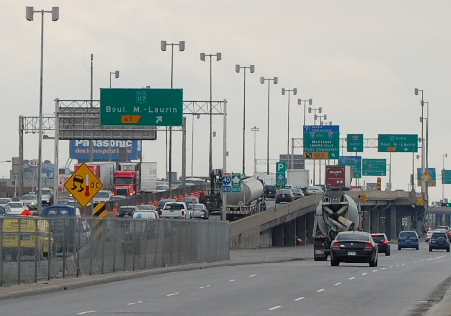
West end of A-15 overlap 67  Route 117 north (Boulevard Marcel-Laurin)
Eastbound exit is via exit 65 68 Rue Stinson, Chemin Rockland Westbound exit is via exit 70 70 A-15 north – Laval, Saint-JérômeEast end of A-15 overlap Montreal Boulevard de l'Acadie Eastbound exit is via exit 68; westbound exit is via exit 71 71 Boulevard Saint-Laurent  Route 335 (Rue Saint-Denis)
Eastbound exit is via exit 71; westbound exit is via exit 73 73 Rue Saint-Hubert, Avenue Christophe-Colomb  A-19 (Avenue Papineau)
Eastbound exit is via exit 73; westbound exit is via exit 75 74 Rue d'Iberville Westbound exit is via exit 75 75 Boulevard Saint-Michel 76  Route 125 (Boulevard Pie-IX) / Boulevard Viau
77 Boulevard Lacordaire Westbound exit is via exit 76 78 Boulevard Langelier, Boulevard Les Galeries-d'Anjou 80 
 A-25 / TCH east to A-20 / Boulevard Henri-Bourassa – Tunnel Louis-Hippolyte-Lafontaine
Signed as exits 80-S (south) and 80-N (north) 82 Boulevard Roi-René, Boulevard Ray-Lawson 85 Boulevard Bourget, Avenue Marien, Boulevard Saint-Jean-Baptiste (eastbound)/(westbound) Montréal-Est Montreal 87 Boulevard Tricentenaire Westbound exit is via exit 85 89  Route 138 (Rue Sherbrooke) / Boulevard Henri-Bourassa
Eastbound exit is via exit 87 92 Boulevard Gouin Eastbound exit and westbound entrance Terrebonne 94  Route 344 – Lachenaie
96  A-640 – Laval, Saint-Eustache, Charlemagne
Signed as exits 96-E (east) and 96-O (west) Charlemagne Repentigny 97 Boulevard Pierre-Le Gardeur – Le Gardeur, Charlemagne Eastbound exit and westbound entrance 98 Repentigny / Le Gardeur 100 Boulevard Industriel, Rue Valmont 102 Rue Valmont (westbound only) L'Assomption 108  Route 341 /
  Route 343 L'Épiphanie, L'Assomption, Saint-Sulpice
Lavaltrie 118 Point-du-Jour Service Area 122  Autoroute 31 /
  Route 131 Joliette / Lavaltrie
Lanoraie 130 Lanoraie Sainte-Geneviève-de-Berthier 141 Rang Sainte-Philomène Berthierville 144  Route 158 Saint-Gabriel, Berthierville
Saint-Cuthbert 151  Route 138 Saint-Cuthbert
Saint-Barthélemy 155 Saint-Bathélémy, Maskinongé Maskinongé 160 Rang de la Rivière Sud-Est Pointe-du-Lac Rest Area Maskinongé - Louiseville Boundary 166 Louiseville, Maskinongé Louiseville - Yamachiche Boundary 174 Route 138 Louiseville, YamachicheYamachiche 180  Route 153 Yamachiche
Trois-Rivières 187 Route 138 Pointe-du-Lac189 Rang St-Charles 192 Chemin des Petites-Terres 196  Autoroute 40 East
  Autoroute 55
  Route 155 Shawinigan / Trois-Rivières, Quebec
(3.5 km concurrency does not count in exit numbering) 197 Autoroute 40 West Autoroute 55 Route 155 Bécancour / Montreal, Shawinigan198 Boulevard des Récollets 199 Boulevard des Forges (indicated as Trois-Rivières Centre-Ville) 201 Boulevard des Chenaux Trois-Rivières 202 Boulevard des Estacades 203  Route 157 Rue Thibeau, Saint-Louis-de-France, Shawinigan-Sud
205 Boulevard des Prairies, Sainte-Marthe-du-Cap Saint-Maurice 210  Route 352 Saint-Maurice
Champlain 220  Route 359 Champlain / Saint-Luc-de-Vincennes / Grand-Mère
Saint-Geneviève-de-Batiscan 229  Route 361 Narcisse / Bastiscan / Sainte-Geneviève-de-Batiscan
Sainte-Anne-de-la-Pérade 236  Route 159 Saint-Prosper / Saint-Casimir / Saint-Tite / Sainte-Anne-de-La-Pérade
Deschambault-Grondines 250 Chemin de St-Casimir Deschambault-Grondines 254  Route 363 Saint-Marc-des-Carrières / Deschambault-Grondines
257 Saint-Gilbert / Deschambault Portneuf 261 Portneuf, Notre-Dame-de-Portneuf (Rue Provencher) Cap-Santé 269  Route 358 Pont-Rouge / Saint-Basile / Cap-Santé
Donnacona 274 Donnacona Neuville 281  Route 365 Pont-Rouge / Saint-Raymond / Neuville
285 Neuville Saint-Augustin-de-Desmaures 295  Route 367 Route de Fossambault, Sainte-Catherine-de-la-Jacques-Cartier / Saint-Augustin-de-Desmaures
298 Route 138 Saint-Augustin-de-Desmaures / L'Anceinne-LoretteSaint-Augustin-de-Desmaures - Quebec City boundary 300 Chemin du Lac Quebec City 302 Route Jean-Gauvin, Cap Rouge 304 Avenue Le Gendre 305  Autoroute 540 Autoroute Duplessis, Pont-Pierre-Laporte / Route de l'Aéroport
306 Avenue Blaise-Pascal 307  Autoroute 73 South (Pont-Pierre-Laporte) Autoroute 540 East
  Autoroute 573 Sainte-Anne-de-Beaupré
308  Route 371 Boulevard Masson, Boulevard de l'Ormière
310 Rue Letourneau / Rue Arnaud 311  Autoroute 740 Autoroute Robert-Bourassa / Boulevard Saint-Jacques
312 Route 358 Vanier; Boulevard Pierre-Bertrand313 Autoroute 73 North  Route 175 Saguenay, Alma / Québec CENTRE-VILLE
315 1ère Avenue 316 Boulevard Henri-Bourassa 318 Avenue du Bourg-Royal 319 Avenue Saint-David 320 Rue Seigneuriale, Beauport CENTRE-VILLE 321 Rue Labelle 322 Boulevard des Chutes 323  Autoroute 440 in Quebec
325 Route 138  Route 368 Ile-d'Orléans
See also
References
- ^ a b "Répertoire des autoroutes du Québec" (in French). Transports Québec. http://www1.mtq.gouv.qc.ca/fr/repertoire_autoroute/autoroute.asp. Retrieved 2008-02-23.
- ^ Ministère des transports, "Distances routières", page (?), Les Publications du Québec, 2005
- ^ 1976 Summer Olympics official report. Volume 2. pp. 156-8.
External links
Preceded by
 ON Highway 417
Trans-Canada Highway
Autoroute 40Succeeded by
 Autoroute 25
Preceded by
 Autoroute 15
Venues of the 1976 Summer Olympics Montreal Olympic Park Greater Montreal Centre Étienne Desmarteau · Complexe sportif Claude-Robillard · Île Notre-Dame · Molson Stadium, McGill University · Montreal Forum · Mount Royal Park · Paul Sauvé Centre · Quebec Autoroute 40 · St. Michel Arena · Streets of Montreal · Winter Stadium, Université de MontréalFootball venues Handball venues Other venues Olympic Archery Field, Joliette · Olympic Equestrian Centre, Bromont · Olympic Shooting Range, L'Acadie · Portsmouth Olympic Harbour (Kingston, Ontario) Portions of the Trans-Canada Highway
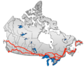 British Columbia: Highway 1 • Highway 5 • Highway 16 | Alberta: Highway 1 • Highway 16
Saskatchewan: Highway 1 • Highway 16 | Manitoba: Highway 1 • Highway 16 • Highway 100
Ontario: Highway 17 • Highway 69 • Highway 400 • Highway 12 • Highway 7 • Highway 71 • Highway 11 • Highway 66 • Highway 417
Quebec: Autoroute 40 • Autoroute 25 • Autoroute 20 • Autoroute 85 • Route 185 • Route 117 • Autoroute 15
New Brunswick: Route 2 • Route 16 | Confederation Bridge | Prince Edward Island: Route 1 | Nova Scotia: Highway 104 • Highway 105 • Highway 106
Newfoundland: Route 1Expressways of Quebec Autoroutes: 5 · 10 · 410 · 610 · 13 · 15 · 19 · 20 · 520 · 720 · 25 · 30 · 31 · 35 · 40 · 440 (Laval) · 440 (Québec) · 540 (Vaudreuil-Dorion) · 540 (Québec) · 640 · 740 · 50 · 55 · 955 · 70 · 73 · 573 · 973 · 85
Future 530 · Former 430 · 550 · 51 · 755 · Unbuilt 6 · 415 · 16 · 18 · 65 · Other routes: 112 · 116 · 117 · 132 · 134 · 138 · 158 · 201 · 335
Roads in CanadaRoads, bridges, and tunnels in Montreal North-south streets Greene Avenue · Atwater Avenue · Côte-des-Neiges Road · Guy Street · Mackay Street · Bishop Street · Crescent Street · Mountain Street · Drummond Street · Stanley Street · Peel Street · Metcalfe Street · Mansfield Street · McGill College Avenue · McTavish Street · University Street · McGill Street · Park Avenue · Saint Urbain Street · Saint Laurent Boulevard · Saint Denis Street · Berri Street · Saint Hubert Street · Christophe Colomb Avenue · Papineau Avenue · De Lorimier Avenue · Pie-IX Boulevard · Saint Michel BoulevardEast-west streets Gouin Boulevard · Henri Bourassa Boulevard · Jarry Street · Jean-Talon Street · Saint Joseph Boulevard · Queen Mary Road · Mount Royal Avenue · Pine Avenue · Doctor Penfield Avenue · Sherbrooke Street · Ontario Street · De Maisonneuve Boulevard · Saint Catherine Street · René Lévesque Boulevard · De la Gauchetière Street · Saint Antoine Street · Saint Jacques Street · Notre-Dame Street · Rue Saint-Paul · Wellington Street · Laurier AvenueExpressways 10 (Bonaventure Expressway) · 13 (Chomedey Expressway) · 15 (Laurentides Expressway) · 19 (Papineau Expressway) · 20 · 25 (Louis-H-Lafontaine Expressway) · 40 (Metropolitan Expressway) · 520 (Côte-de-liesse Expressway) · 720 (Ville-Marie Expressway)Routes Bridges and tunnels List of bridges in Montreal · Champlain Bridge · Charles de Gaulle Bridge · Galipeault Bridge · Honoré Mercier Bridge · Jacques Cartier Bridge · Île aux Tourtes Bridge · Louis-Hippolyte Lafontaine Bridge-Tunnel · Louis Bisson Bridge · Médéric Martin Bridge · Papineau-Leblanc Bridge · Pie IX Bridge · Pierre Le Gardeur Bridge · Viau Bridge · Victoria Bridge · Tunnel de la mortCategories:- 1976 Summer Olympic venues
- Repentigny, Quebec
- Quebec Autoroutes
- Trans-Canada Highway
- Transportation in Montreal
- Transportation in Quebec City
- Transportation in Trois-Rivières
- Vaudreuil-Dorion


Wikimedia Foundation. 2010.