De la Gauchetière Street

De la Gauchetière Street
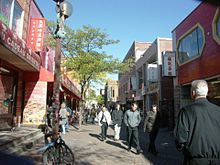
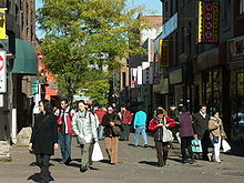
De la Gauchetière Street is a car free zone in Montreal's Chinatown.
De la Gauchetière Street and Saint Urbain Street in Chinatown.

De la Gauchetière Street (official French name: rue de la Gauchetière) is a street in Montreal, Quebec, Canada, running through downtown Montreal, the Quartier international and Chinatown.

In Chinatown, it takes the form of a pedestrian zone, between Saint Laurent Boulevard and Jeanne-Mance Street.

Points of interest

The street runs through the central business district, and is home to such landmarks as Place Bonaventure, the 1000 de la Gauchetière skyscraper, the Château Champlain and the Bell Centre. De la Gauchetiere also forms the southern edge of Place du Canada.

Montreal's two main railway stations are located on the street: Central Station and Lucien L'Allier station. Historic Windsor Station is also located on De la Gauchetière, but is no longer used for train service, the Bell Centre occupying the area where the tracks were located.

Etymology

The name has been unofficially translated variously as La Gauchetière Street (such as inside the elevator in Windsor Station) and Gauchetière Street. However, the name does not mean "of the Gauchetière"; rather, de la here is part of the proper name, as it is named after the landowner Joseph-Daniel Migeon, also called the Sieur de la Gauchetière in honor of his mother Catherine Gauchet.

Coordinates: 45°30′30″N 73°33′35″W / 45.508356°N 73.559802°W / 45.508356; -73.559802


Wikimedia Foundation. 2010.

Игры ⚽ Поможем написать курсовую

Look at other dictionaries:

  • Drummond Street, Montreal — For other uses, see Drummond Street. Drummond Street Rue Drummond Drummond Street looking southward. Length: 1.2 km (0.7 mi) …   Wikipedia

  • 1000 de La Gauchetière — Infobox Skyscraper building name = Le 1000 de La Gauchetière | built = 1992 use = Office location = Montreal, Quebec Canada roof = 205 m (673 feet) top floor = antenna spire = floor count = 51 floor area = elevator count = architect = Lemay… …   Wikipedia

  • Crescent Street — Rue Crescent Crescent Street looking northward. Length: 0.6 km (0.4 mi) …   Wikipedia

  • Mansfield Street, Montreal — Mansfield Street Rue Mansfield Length: 1 km (0.62 mi) Location: Between Sherbrooke Street and Saint Antoine Street Coordinates …   Wikipedia

  • McGill Street (Montreal) — Not to be confused with McGill College Avenue. McGill Street Rue McGill McGill Street, looking north from the Lachine Canal …   Wikipedia

  • McTavish Street — McGill s Redpath Library building as seen from McTavish Street in 1935. McTavish Street is a street in Montreal, Quebec, Canada. This street runs up the slope of Mount Royal, from Sherbrooke Street at its southern end, to Pine Avenue. Adjacent to …   Wikipedia

  • Metcalfe Street (Montreal) — For other uses, see Metcalfe Street (disambiguation). Metcalfe Street Rue Metcalfe Metcalfe Street and the Sun Life Building. Le …   Wikipedia

  • Ontario Street (Montreal) — Ontario Street (French: Rue Ontario) is an east west artery in Montreal, Quebec, Canada. It crosses the boroughs of Ville Marie and Mercier–Hochelaga Maisonneuve. It is in the latter that the street becomes predominantly commercial, and is known… …   Wikipedia

  • Mountain Street — Rue de la Montagne Rue de la Montagne looking southward. Length: 2.2 km (1.4 mi) Location: Between Doctor Penfield Avenue and Welli …   Wikipedia

  • Notre-Dame Street — Montreal City Hall on Notre Dame, winter night …   Wikipedia

Share the article and excerpts

Direct link
Do a right-click on the link above
and select “Copy Link”