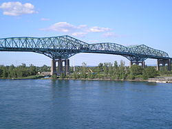
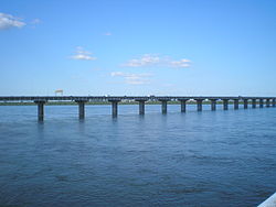
- Champlain Bridge, Montreal
-
Champlain Bridge Carries Commuter and transit traffic for Autoroute 10, 15, 20 Crosses St. Lawrence River Locale Brossard, Quebec and Montreal, Quebec Owner Federal Bridge Corporation Ltd via JCCBI Design Steel truss cantilever bridge Material Steel, concrete, asphalt Total length 3,400 m (11,155 ft) Width Six lanes Opened 1962 Toll Collected until 1990 Daily traffic 159,000[1]. Coordinates 45°28′07″N 73°31′03″W / 45.46861°N 73.5175°WCoordinates: 45°28′07″N 73°31′03″W / 45.46861°N 73.5175°W The Champlain Bridge (French: Pont Champlain) is a steel truss cantilever bridge with approach viaducts constructed of prestressed concrete beams supporting a prestressed concrete deck paved with asphalt. The bridge crosses the Saint Lawrence River and Saint Lawrence Seaway, connecting the Montreal boroughs of Verdun and Le Sud-Ouest to Brossard on the South Shore,
The bridge, with approaches, is approximately 6 km (3.7 mi) in length. When the project began, it was designated as the "Nuns' Island Bridge" because it crosses over Nuns' Island. In 1958, it was officially named the Champlain Bridge in honour of the explorer Samuel de Champlain who founded Quebec City in 1608.
Together with the Jacques Cartier Bridge, it is administered by the Jacques Cartier and Champlain Bridges Incorporated (JCCBI), a federal agency which is a fully owned subsidiary of the Federal Bridge Corporation Limited.
With nearly 160,000 daily crossings, the Champlain Bridge is the busiest bridge in Canada (the Hogg's Hollow bridge system in Toronto is the busiest multi-structure bridge in North America, with four separate bridges averaging a combined 400,000 + vehicles a day through Highway 401).
Contents
Construction history
On August 17, 1955, federal Transport Minister George Marler first announced the planned construction of a new bridge connecting Montreal to the South Shore via Nun's Island. The city's existing bridges (Victoria, Jacques Cartier and Honoré Mercier) had become inadequate to support the amount of traffic that carried residents from the growing South Shore suburbs into Montréal.
The National Harbours Board was placed in charge of the project. Through several lengthy meetings and consultations in the fall of 1955, the location for the bridge and its approaches were selected. Originally, the plan had been to build the bridge with only 4 lanes, with room for further expansion to 6 lanes. During the design phase however it was decided to go with an initial 6-lane design immediately.
The bridge was opened on June 29, 1962. At the time, the bridge had only one approach from Montreal, via Wellington Street. The section of the bridge that includes the approaches to and from Atwater Street and La Vérendrye Boulevard were opened two years later, on December 7, 1964.
In 1967, the final approach to the bridge on the Montréal side was completed when the Bonaventure Expressway was opened to traffic.[2]
A 25-cent toll (8-cents if paid with tokens) was charged to finance the C$35 million cost of the Champlain Bridge. The toll was collected until 1990, when the Jacques Cartier and Champlain Bridges Incorporated (JCCBI), which took over jurisdiction of the bridge a dozen years earlier, removed the toll plaza.[3] Currently, a new toll project exists which may result in booths returning to the predetermined spaces on Ile-des-Soeurs, so that drivers can be charged for entering and exiting Montréal. The toll will not be higher than $2.00 for a start.
Plans for bridge replacement
On September 20, 2007, a major French-language Montreal daily, Le journal de Montréal, published a story about federal government plans to build a new 10-lane span next to Champlain Bridge, rather than face the increasing maintenance cost of the aging structure.[4] Federal minister Lawrence Cannon confirmed that his ministry is seriously considering the prospect of a new bridge.[5]
In October 2007, Novaroute, a private firm, revealed a plan to construct a two-story tunnel bridge under the Saint Lawrence River that would also collect tolls based on the time period. In Novaroute's plan, one level would be for buses and trains while the second would be for all other vehicles except tractor-trailers. The tunnel would be built under a public-private partnership and take five years to complete.[6]
In August 2008, the Transport Canada, the federal ministry of transportation, confirmed that studies and scenarios were ordered to build a new bridge within 10 or 15 years. The new structure would likely be 8 to 10 lanes wide and include a light rail train to connect the South Shore to Montreal.[7][8]
On January 27, 2009, the Government of Canada announced in its 2009 Economic Action Plan that it would be allocating $212 million to renew the bridge.
On March 18, 2011, the Government of Canada announced $158 million will be spent on a major repair and maintenance program as concerns mount it is at risk of collapse. Montreal's La Presse newspaper cited two leaked engineering reports prepared for a federal bridge agency that suggest sections of the structure are in a severe state of deterioration that will be progress exponentially. The report concludes that a partial or complete collapse of the span should not be ruled out.[9]
On October 5, 2011, The Honourable Denis Lebel announced that the Canadian Federal Government will proceed with a new bridge across the St. Lawrence in Montreal.[10][11]
Structural health
Montreal's climate subjects the Champlain Bridge to wintry cold, snowfall, and windy conditions, all of which accelerate damage to the bridge. Because of the potential danger from ice accumulation, the bridge has been salted every season for decades. But salt attacks both the concrete and steel rebar used in girders, pylons, and other parts.
In 2010, JCCBI — the Federal agency that oversees the structure — retained international engineering firm Delcan to carry out an expert study of the bridge's structural health. The firm returned a carefully-worded report entitled, "The Future of the Champlain Bridge Crossing". In the Executive Summary, the bridge was said to be "functionally deficient" for both current and long-term traffic demands, and showing "significant deterioration".[12] One finding suggested that the Champlain Bridge is in "very much poorer condition than would be typical" for comparable bridges. Delcan concluded that the bridge had "many deficiencies" and, even in light of the methodical inspection and rehabilitation of the structure undertaken by its owners, that continued operation "entails some risks that cannot altogether be quantified".
The CBC Television and Télévision de Radio-Canada, among other news agencies, have published segments highlighting concerns over conditions of surface roads in Montreal and the Champlain Bridge in particular.
See also
- List of longest bridges in the world
- List of bridges
- List of crossings of the Saint Lawrence River
- List of bridges in Montreal
- Federal Bridge Corporation Limited
References
- ^ Sources disagree on the actual figure:
- Transport Canada says 49 million vehicles/year cross the bridge ("Transport Canada - Surface Infastructure Programs - Bridges: Champlain Bridge". Transport Canada. http://www.tc.gc.ca/programs/surface/bridges/champlainMontréal.htm. Retrieved 2008-08-25.);
- JCCBI, the corporation in charge of maintaining the bridge, quotes 57.1 million vehicles ("The Champlain Bridge and Bonaventure Expressway". The Jacques Cartier and Champlain Bridges. http://www.pjcci.ca/English/champlain/intro.htm. Retrieved 2008-08-25.);
- The 2006-2007 Federal Bridge Corporation annual report counts 58.2 million ("Annual Report" (pdf). Federal Bridge Corporation. 2007. pp. 15. http://www.federalbridge.ca/Portals/0/annual_reports/fbcl_report_2006-07_eng.pdf. Retrieved 2008-08-25.);
- A June 2008 La Presse article suggests 58 million without attributing the source (Bruno Bisson f (2008-06-11). "Circulation: une pagaille monstre, vite résorbée" (in French). La Presse. http://www.cyberpresse.ca/article/20080611/CPACTUALITES/80610256/0/CPACTUALITES. Retrieved 2008-08-25.)
- ^ "The Champlain Bridge and the Bonaventure Expressway". http://www.pjcci.ca/English/pdf/CHAMPLAIN-INTERNET-ang.pdf. Retrieved 2008-07-01.
- ^ "The Champlain Bridge:Historic overview". http://www.montrealroads.com/crossings/champlain. Retrieved 2009-04-29.
- ^ "Un super-pont de huit ou dix voies?" (in French). Canoe.ca. 2007-09-20. http://argent.canoe.com/lca/infos/quebec/archives/2007/09/20070920-091228.html. Retrieved 2007-10-05.
- ^ "Officials mull replacing Montréal's Champlain Bridge". The Gazette. 2008-08-18. http://www.canada.com/montrealgazette/news/story.html?id=6fbaa8d0-8f8c-425f-8a43-f8d1c3d5ebaf. Retrieved 2008-08-18.
- ^ "Un nouveau tunnel sous le fleuve?" (in French). LCN. http://lcn.canoe.ca/lcn/infos/regional/archives/2007/10/20071010-082427.html. Retrieved 2008-07-01.
- ^ "Un pont tout neuf" (in French). Le journal de Montréal. 2008-08-18. http://www.canoe.com/infos/quebeccanada/archives/2008/08/20080818-043901.html. Retrieved 2008-11-05.
- ^ "Quebec welcomes talk of a new Champlain bridge". CBC. 2008-08-19. http://www.cbc.ca/canada/montreal/story/2008/08/19/mtl-champlain0818.html?ref=rss. Retrieved 2008-11-05.
- ^ "Montreal bridge gets $158M in repair funds". CBC News. 2011-03-18. http://www.cbc.ca/news/canada/montreal/story/2011/03/18/champlain-bridge-repair-funding.html. Retrieved 2011-03-18.
- ^ http://www.theglobeandmail.com/news/politics/ottawa-announces-10-year-plan-to-replace-montreals-champlain-bridge/article2191286/
- ^ http://www.tc.gc.ca/eng/mediaroom/releases-2011-h100e-6493.htm
- ^ Delcan, Inc (2011-03-28). "Future of the Champlain Bridge Crossing". pjcci.ca. http://www.pjcci.ca/Francais/champlain/Future%20of%20the%20Champlain%20Bridge%20Mar%2028%2011.pdf. Retrieved 2011-04-11.
External links
- Champlain Bridge (Jacques Cartier and Champlain Bridges Incorporated, Government of Canada)
- Steve Anderson's MontrealRoads.com: Champlain Bridge (A-10, A-15, and A-20)
- Champlain Bridge at Structurae
- Google 3D warehouse
Bridges of the St. Lawrence River Upstream
Honoré Mercier Bridge

Champlain Bridge


Downstream
Victoria Bridge
 Categories:
- Cantilever bridges
- Bridges completed in 1962
- Bridges in Montreal
- Transportation in Brossard
- Bridges over the Saint Lawrence River
- Proposed bridges in Canada
Wikimedia Foundation. 2010.


