- Montréal-Sud
-
Montréal-Sud (English: Montreal South) was a suburb of Montréal located on the south shore of the St. Lawrence River founded in 1906. [1] Montréal-Sud was created from land of the Saint-Antoine-de-Longueuil parish. Originally a village in its first five years, Montréal-Sud gained the status of city in 1911.
 Rue Sainte-Hélène in the former city
Early in its existence, its population was split between French-speaking Roman Catholics and English-speaking Protestants. This changed by the middle of the century, as the Francophones became the overwhelming majority.[1]
The approximate territorial limits of the city were La Fayette Boulevard in the west, Bertrand Street in the south, Joliette Street in the east and St. Lawrence River in the north.[1]
Like neighbouring Longueuil, Montréal-Sud was an enclave of the parish Saint-Antoine-de-Longueuil (later known as Ville Jacques-Cartier).
Contents
Merger with Longueuil and aftermath
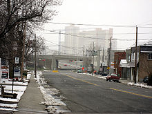
 Downtown Longueuil.
On January 28, 1961, the city of Montréal-Sud merged with the city of Longueuil, keeping the latter's name.[1] After Montréal-Sud was dissolved, its former territory underwent a major urban renewal that began in the mid-1960s.
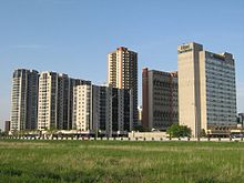
Downtown Longueuil
Place Charles-LeMoyne, often considered to be Downtown Longueuil, is in the former territory of Montréal-Sud.
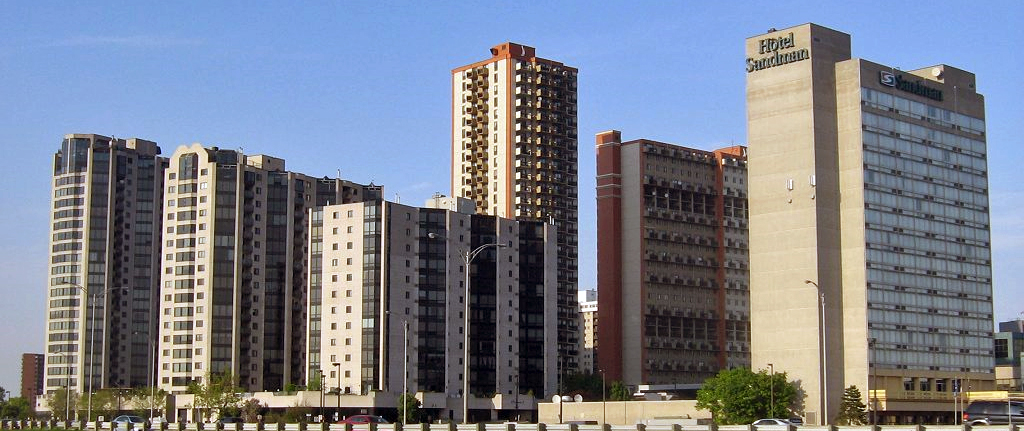
It is the location of the Longueuil bus terminus and Longueuil-Université-de-Sherbrooke metro station. Most of Longueuil's high-rise residential and office buildings are located in this area, including 99 Place Charles-LeMoyne, which is 30 stories tall, and is the tallest building in Greater Montreal off the Island of Montreal.[2]
There is also a hotel on de Sérigny street. Since 1972, the hotel has carried the banners Holiday Inn, Ramada, Radisson and now Sandman. Although it is currently in the hands of the Sandman Inn Group, it had been a Holiday Inn hotel for most of its existence.
Université de Sherbrooke constructed a campus in the area, including a 17-story and a 12 story tower.[3]
Place Charles-LeMoyne is surrounded by major highways, Autoroute 20/Route 132 near the river in the north, the entrance ramp of Jacques-Cartier Bridge to the west, and Taschereau Boulevard to the south and east.
Place Longueuil
Also located within the former municipal boundaries of Montréal-Sud is Place Longueuil, which is located just outside of Downtown Longueuil.
Place Longueuil was the first shopping mall in Longueuil and is now the largest mall within city limits. Place Longueuil lies right next to Old Longueuil and many locales consider the mall as part of this neighborhood.
Mayors
Mayors of Montréal Sud Mayor Term Began Term Ended John Smillie 1906 1910 Napoléon Labonté 1910 1912 John Smillie 1912 1916 Edmond Hardy 1916 1924 David McQuaid 1924 1932 Henry Hamer 1932 1936 Clément Patenaude 1936 1938 Harry T. Palmer (resigned) 1938 1939 James Brindley (resigned) 1939 1942 Robert Gault Keers 1942 1948 Édouard Richer 1948 1950 Aimé Lefebvre 1950 1952 Marcel Salette 1952 1958 Sylva Charland 1958 1961 Population
Year Population 1911 790 1921 1030 1931 1164 1941 1441 1951 4214 1958 5 494 1961 Merged with Longueuil Location (1960)

Saint Lawrence River Ville Jacques-Cartier 
Longueuil  Montréal-Sud

Ville Jacques-Cartier References
- ^ a b c d Société historique et culturelle du Marigot Nouvelles villes
- ^ "99 Place Charles-Le Moyne". Longueuil. Emporis. http://www.emporis.com/en/wm/bu/?id=99placecharleslemoyne-longueuil-canada. Retrieved 2008-12-29.
- ^ "L'Université de Sherbrooke investit à Longueuil". Radio-Canada. May 9, 2005. http://www.radio-canada.ca/nouvelles/Index/nouvelles/200505/09/005-UNIVERSITESHERBROOKE.shtml. Retrieved 2008-12-29.
Urban agglomeration of Longueuil Cities Boroughs of Longueuil Pre-2002 towns and cities (now merged) Jacques-Cartier · Mackayville-Laflèche · LeMoyne · Montreal South (Montréal-Sud) · Notre-Dame-du-Sacré-Cœur · PrévillePolitics Transportation Réseau de transport de Longueuil (RTL) · Longueuil–Université-de-Sherbrooke (Montreal Metro) · Montréal/Saint-Hubert Airport · Jacques-Cartier Bridge · Champlain Bridge · Victoria Bridge · Louis-Hippolyte Lafontaine Bridge-Tunnel · Taschereau Boulevard · Victoria AvenueHealth and Safety Hôpital Charles LeMoyne · Hôpital Pierre-Boucher · Service de police de Longueuil (SPL) · Service de Sécurité incendie de Longueuil (SSIL)Education Media Other Categories:- 1906 establishments in Canada
- 1961 disestablishments
- Former municipalities in Quebec
- Longueuil

Wikimedia Foundation. 2010.