Christophe Colomb Avenue

Christophe Colomb Avenue
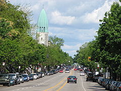
Christophe Colomb Avenue, seen northbound, with the tower of Église St-Arsène.

Christophe Colomb Avenue (French: Avenue Christophe-Colomb) is a major north-south street in Montreal, Quebec, Canada. It has a length of 8.5 Kilometres, and crosses the boroughs of Le Plateau-Mont-Royal, Rosemont-La Petite-Patrie, Villeray-Saint-Michel-Parc-Extension and Ahuntsic-Cartierville. The street is predominantly residential south of Villeray Street and is a large urban boulevard to the north.

The street was named after Christopher Columbus on December 20, 1897.

Christophe Colomb Avenue begins at Rachel Street, near Lafontaine Park in the south. It is a prolongation of Parc-Lafontaine Street. It is interrupted by Sir Wilfrid Laurier Park between Laurier Avenue and Saint Grégoire Street for distance of 400 metres. In the north, the street ends at Gouin Boulevard, near Louis Hébert Park and the Rivière des Prairies.

Points of interest

Coordinates: 45°32′43″N 73°36′58″W / 45.5453°N 73.616°W / 45.5453; -73.616


Wikimedia Foundation. 2010.

Игры ⚽ Поможем сделать НИР

Look at other dictionaries:

  • Avenue Christophe-Colomb — Pour les articles homonymes, voir Christophe Colomb (homonymie). 45° 32′ 43″ N 73° 36′ 57″ W …   Wikipédia en Français

  • Christophe Colomb (homonymie) — Cette page d’homonymie répertorie les différents sujets et articles partageant un même nom. Christophe Colomb (1451 1506) est un célèbre explorateur génois. Sur ses origines, voir l article : Théories sur l origine de Christophe Colomb Il a… …   Wikipédia en Français

  • Rue Christophe-Colomb — Pour les articles homonymes, voir Christophe Colomb (homonymie). 8e arrt …   Wikipédia en Français

  • Avenue Du Mont-Royal — 45° 31′ 27″ N 73° 34′ 57″ W / 45.524303, 73.582606 …   Wikipédia en Français

  • Avenue Du Parc — 45° 30′ 46″ N 73° 34′ 50″ W / 45.512743, 73.580603 …   Wikipédia en Français

  • Avenue Mont-Royal — Avenue du Mont Royal 45° 31′ 27″ N 73° 34′ 57″ W / 45.524303, 73.582606 …   Wikipédia en Français

  • Avenue Mont Royal — Avenue du Mont Royal 45° 31′ 27″ N 73° 34′ 57″ W / 45.524303, 73.582606 …   Wikipédia en Français

  • Avenue Robert-Bourassa — Avenue du Parc 45° 30′ 46″ N 73° 34′ 50″ W / 45.512743, 73.580603 …   Wikipédia en Français

  • Avenue du mont-royal — 45° 31′ 27″ N 73° 34′ 57″ W / 45.524303, 73.582606 …   Wikipédia en Français

  • Avenue du parc — 45° 30′ 46″ N 73° 34′ 50″ W / 45.512743, 73.580603 …   Wikipédia en Français

Share the article and excerpts

Direct link
Do a right-click on the link above
and select “Copy Link”