- Ahuntsic-Cartierville
-
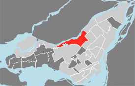
Ahuntsic-Cartierville — Borough of Montreal — Location of Ahuntsic-Cartierville on the Island of Montreal.
(Grey areas indicate demerged municipalities).Country  Canada
Province  Quebec
Region Montréal Established January 01, 2002 Electoral Districts
Federal
Saint-Laurent—Cartierville
AhuntsicProvincial Saint-Laurent
Acadie
CrémazieGovernment[1][2][3] - Type Borough - Mayor Pierre Gagnier - Federal MP(s) Stéphane Dion (LIB)
Maria Mourani (BQ)- Quebec MNA(s) Jean-Marc Fournier (PLQ)
Christine St-Pierre (PLQ)
Lisette Lapointe (PQ)Area - Total 22.92 km2 (8.8 sq mi) Population - Total 125,160 - Density 5,460.7/km2 (14,143.1/sq mi) Time zone EST (UTC-5) - Summer (DST) EDT (UTC-4) Area code(s) (514) and (438) Access Routes[4]
 A-15
A-15
 A-19
A-19
 A-40
A-40
 Route 117
Website ville.montreal.qc.ca/ahuntsic-cartierville Ahuntsic-Cartierville is a borough (arrondissement) of the city of Montreal, Quebec, Canada.
Contents
Geography
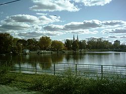
The borough is located in the northern part of Montreal along the banks of the Rivière des Prairies, and includes some islands in the river such as Île aux Chats, Île Perry, and Île de la Visitation. It is bounded to the east by Montreal North, to the southeast by the borough of Villeray–Saint-Michel–Parc-Extension, to the southwest by the borough of Saint-Laurent, and to the west by the borough of Pierrefonds-Roxboro. It has an area of 22.92 km² and a population of 125,160.
Politics
Municipal
The borough's office is located at 10794 Lajeunesse. The territory is divided into four districts.
Borough council
As of the November 1, 2009 Montreal municipal election, the current borough council consists of the following councillors:
District Position Name Party — Borough mayor
City councillorPierre Gagnier Independent Ahuntsic City councillor Émilie Thuillier Projet Montréal Bordeaux-Cartierville City councillor Harout Chitilian Union Montréal Saint-Sulpice City councillor Jocelyn Ann Campbell Union Montréal Sault-au-Récollet City councillor Étienne Brunet Vision Montréal Federal and provincial
Federally, the borough is divided between the ridings of Saint-Laurent—Cartierville and Ahuntsic, with a small portion in the riding of Bourassa. Provincially, the borough is divided between the Saint-Laurent, Acadie, and Crémazie electoral districts.
Education
The Collège de Bois-de-Boulogne and the Collège Ahuntsic are located in Ahuntsic-Cartierville. The borough has three libraries: Ahuntsic (adults and children), Cartierville (adults and children) and De Salaberry (children's only).[5]
English-language schools
The English Montreal School Board (EMSB) is in charge of English-language elementary and secondary schools in the borough of Ahuntsic-Cartierville. EMSB elementary schools include: John Caboto, Cedarcrest, Parkdale and St. Dorothy.
Features
Transportation
The borough is served by the north-eastern part of the orange line of the Montreal subway (Henri-Bourassa, Sauvé, and Crémazie stations); by the Deux-Montagnes (Bois-Franc station) and Blainville-Saint-Jerome (Bois-de-Boulogne Station) AMT commuter train lines; and by Quebec Autoroutes 15 (Laurentian Autoroute/Autoroute des Laurentides) and 40 (Metropolitan Autoroute/Autoroute Métropolitaine).
Healthcare
Sacré-Coeur Hospital and Fleury Hospital service the area. The CLSC de Bordeaux-Cartierville also responds to citizen's health care needs (See also CLSC).
Sports and other activities
Ahuntsic-Cartierville features large parks along its riverside, such as Île Perry and Parc de l'Île de la Visitation, which offer views of the river and of nearby Laval, Quebec. The borough is also traversed by the Route Verte, a province-wide network of bicycle paths. The Complexe sportif Claude-Robillard, located at 1000 Émile-Journault Avenue, is one of the main sport complexes in the area.
History
Sault-au-Récollet
See also: Sault-au-RécolletOne of the oldest villages on the island of Montreal, Sault-au-Récollet still retains its village atmosphere with many houses dating from the 18th and 19th centuries. It was the original site of Fort Lorette, a trading post and mission for the conversion of the First Nations people of the area.
It grew prosperous in the 18th century with the construction of a mill on the rapids on the Rivière des Prairies (from which the village derives its name: Sault-au-Récollet, or Recollet Falls). A dam was built on the narrow arm of the river that passes between the village and Visitation Island, which splits the river in two at that point. A museum and cultural centre, the Maison du Pressoir, perpetuates this memory. A hydroelectric dam was built later and still exists further down the river.
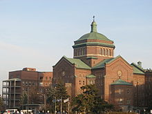
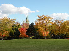
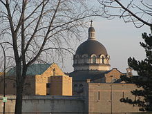
The village and Visitation Island are surrounded by the green space of the Parc-Nature de l'Île de la Visitation. The village is noted for Visitation Church, one of the oldest churches in Montreal, which is a listed historical monument.
Cartierville
Cartierville grew as a suburb when it became in 1898 the north terminus of the Montreal Park and Island Railway tramway line, also known as the "17-Cartierville". Named in the honor of Sir George-Étienne Cartier, it became a village officially in 1906. During December 1912, it achieved city status. Two years later, the rural and agricultural part of Cartierville was granted independence from the city and was then known as Ville de Saraguay.
On 22 December 1916, the provincial government ordered the annexation of Cartierville to Montreal. The district was famous for the Belmont Park amusement park which operated from 1929 to the 1980s.
Nouveau-Bordeaux
New Bordeaux (or simply Bordeaux) was originally part of the independent village of Cartierville until it became its own municipality in 1898. The district was originally named Saint-Joseph de Bordeaux until 1906. One year later, Bordeaux attained city status. On June 4, 1910, it was annexed by the larger City of Montreal. The district was home to Maurice Richard, writer Claude Jasmin and Comte Daeylar.
Village of Ahuntsic and Ahuntsic district
See also: AhuntsicThe municipality of the Village of Ahuntsic was founded on January 21, 1897, by a proclamation of the Quebec provincial government. The council of the new village operated until 1910, when the province passed laws creating the charter of the City of Montreal. It was then annexed and later combined with Nouveau-Bordeaux, forming the district of Ahuntsic-Bordeaux. The city of Cartierville and Sault-au-Récollet were added in 1918.
In 1952, following a land exchange, Ahuntsic took over part of Saint-Laurent. The Ahuntsic-Cartierville borough was part of the City of Montreal prior to January 1, 2002. For further reading on pre-merger Montreal, see Karen Herland's book "People, Potholes and Politics".
Ville de Saraguay
In 1914, the rural and agricultural part of the city of Cartierville became independent, forming its own city. It was only in 1964, three years prior to Expo 67 (the city's successful World's Fair), that Saraguay joined itself to the City of Montreal under law 2926 approved by the lieutenant-general of the province of Quebec.
See also
- Boroughs of Montreal
- Centrale de la Rivière des Prairies
- Districts of Montreal
- Municipal reorganization in Quebec
References
- ^ Ministère des Affaires Municipales et Régions: Ahuntsic-Cartierville (Montreal)
- ^ Parliament of Canada Federal Riding History: SAINT-LAURENT--CARTIERVILLE (Quebec)
Parliament of Canada Federal Riding History: AHUNTSIC (Quebec)
Parliament of Canada Federal Riding History: BOURASSA (Quebec) - ^ Chief Electoral Officer of Québec - 40th General Election Riding Results: SAINT-LAURENT
Chief Electoral Officer of Québec - 40th General Election Riding Results: ACADIE
Chief Electoral Officer of Québec - 40th General Election Riding Results: CRÉMAZIE - ^ Official Transport Quebec Road Map
- ^ Bibliothèque de Montréal(French)
External links
- Borough website (French)

Rivière des Prairies Rivière des Prairies  Montréal-Nord (Montreal)
Rivière des Prairies 
 Villeray--Saint-Michel--Parc-Extension (Montreal)
 Ahuntsic-Cartierville (Montreal)

 Pierrefonds-Roxboro (Montreal)
 Saint-Laurent (Montreal)
Mount Royal Categories:
Wikimedia Foundation. 2010.

