- Côte-des-Neiges–Notre-Dame-de-Grâce
-
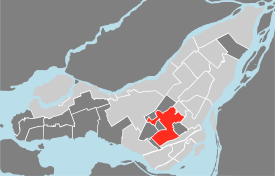
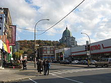
Côte-des-Neiges–Notre-Dame-de-Grâce — Borough of Montreal — The CdN-NDG Borough Hall, adjacent to the Décarie Expressway. Location of Côte-des-Neiges–Notre-Dame-de-Grâce on the Island of Montreal.
(Grey areas indicate demerged municipalities).Country  Canada
Province  Quebec
Region Montreal (06) Created January 1, 2002 Electoral Districts
Federal
Mount Royal
Outremont
Westmount—Ville-Marie
Notre-Dame-de-Grâce—LachineProvincial D'Arcy-McGee
Notre-Dame-de-Grâce
Outremont
Mont-RoyalGovernment[1][2][3] – Type Borough – Mayor Michael Applebaum (UM) – Federal MP(s) Irwin Cotler (LIB)
Thomas Mulcair (NDP)
Marc Garneau (LIB)
Isabelle Morin (NDP)– Quebec MNA(s) Lawrence S. Bergman (PLQ)
Kathleen Weil (PLQ)
Raymond Bachand (PLQ)
Pierre Arcand (PLQ)Area – Total 20.01 km2 (7.7 sq mi) Population (2007 est.) – Total 163,110 – Density 8,151.4/km2 (21,112/sq mi) Time zone EST (UTC-5) – Summer (DST) EDT (UTC-4) Area code(s) 514/438 Access Routes[4]
 A-15
A-15
 Route 138
Website www.ville.montreal.qc.ca Côte-des-Neiges–Notre-Dame-de-Grâce is a borough (arrondissement) of Montreal, Quebec, Canada
Contents
Geography
Located to the north and west of Mount Royal, it was part of the City of Montreal prior to the 2002 municipal mergers. It is composed of the districts of Notre-Dame-de-Grâce and Côte-des-Neiges.
The irregularly shaped borough is bounded on the north by the borough of Mount Royal, on the east by Outremont, on the southeast by Ville-Marie and Westmount, on the south by Le Sud-Ouest, and on the west by Côte Saint-Luc, Hampstead, and Montreal West. The Notre Dame des Neiges Cemetery is in the south east corner of the borough.
It has an area of 20,01 km² and a population of 163,110, making it the most populous of Montreal's boroughs.
Government
Municipal
As of the November 1, 2009 Montreal municipal election, the current borough council consists of the following councillors:
District Position Name Party — Borough mayor
City councillorMichael Applebaum Union Montréal Côte-des-Neiges City councillor Helen Fotopulos Union Montréal Darlington City councillor Lionel Perez Union Montréal Loyola City councillor Susan Clarke Union Montréal Notre-Dame-de-Grâce City councillor Peter McQueen Projet Montréal Snowdon City councillor Marvin Rotrand Union Montréal Federal and provincial
The borough is divided among the following federal ridings:
- Mount Royal
- Outremont
- Westmount—Ville-Marie
- Notre-Dame-de-Grâce—Lachine
It is divided among the following provincial electoral districts:
- D'Arcy-McGee
- Notre-Dame-de-Grâce
- Outremont
- Mont-Royal
Features
The borough is traversed by the Autoroute Décarie, and is served by the orange and blue line of the Montreal metro.
Attractions in the area include Concordia University's Loyola campus, Notre-Dame-des-Neiges Cemetery, Université de Montréal, Saint Joseph's Oratory and the Gibeau Orange Julep fast-food restaurant.
The borough is also the home of a sizable Romanian Community, one of the most important in Quebec.
See also
- Boroughs of Montreal
- Districts of Montreal
- Municipal reorganization in Quebec
References
- ^ Ministère des Affaires Municipales et Régions: Côte-des-Neiges–Notre-Dame-de-Grâce (Montreal)
- ^ Parliament of Canada Federal Riding History: MOUNT ROYAL (Quebec)
Parliament of Canada Federal Riding History: OUTREMONT (Quebec)
Parliament of Canada Federal Riding History: WESTMOUNT--VILLE-MARIE (Quebec)
Parliament of Canada Federal Riding History: NOTRE-DAME-DE-GRÂCE--LACHINE (Quebec) - ^ Chief Electoral Officer of Québec - 40th General Election Riding Results: D'ARCY-MCGEE
Chief Electoral Officer of Québec - 40th General Election Riding Results: NOTRE-DAME-DE-GRÂCE
Chief Electoral Officer of Québec - 40th General Election Riding Results: OUTREMONT
Chief Electoral Officer of Québec - 40th General Election Riding Results: MONT ROYAL - ^ Official Transport Quebec Road Map
External links

 Outremont (Montreal)
 Ville-Marie (Montreal)
Mount Royal 
Westmount  Côte-des-Neiges–Notre-Dame-de-Grâce

Hampstead
Cote-Saint-LucMontreal West
 Lasalle (Montreal)
 Le Sud-Ouest (Montreal)
Coordinates: 45°28′34″N 73°37′37″W / 45.47617°N 73.62705°W
Categories:
Wikimedia Foundation. 2010.


